
The myth that northern Hudson Bay communities are having problems with polar bears this year because freeze-up is later than usual just won’t go away.
I discussed the well publicized craziness in Churchill last week (here and here), but there’s more. Polar bears are already leaving the shore of Northern Hudson Bay as the ice rapidly forms but I saw a story yesterday (dated late last week) that quoted a local official in Repulse Bay blaming their polar bear problems on late freeze-up.
I’ve written before about the peer-reviewed paper by polar bear researchers Seth Cherry and colleagues published earlier this year on breakup and freeze-up dates between 1991 and 2009. But perhaps the freeze-up data needs more emphasis. I’ve copied that graph again below, with notes, and added some ice maps. See for yourself.
Bottom line: A “late freeze-up” for northwestern Hudson Bay occurs when ice formation is delayed until early December or beyond. Freeze-up was nowhere near “late” this year, nor was the ice “slow to freeze.” It wasn’t last year either.
Here’s the story that caught my attention: “Arviat copes daily with polar bears on fall migration: Repulse Bay, Chesterfield Inlet and Hall Beach also witness high bear traffic” (NunatsiaqOnline, November 15, 2013).
“Like many communities in Nunavut’s Kivalliq region, Arviat sees many more polar bears than usual from late-October to the start of December.
But this year’s season is a little busier than normal in some hamlets — and Arviat is seeing the busiest by far.
The community encounters polar bear situations every fall as sea ice on the coastline of Hudson Bay freezes, “and we’re at that stage right now,” said Jonathan Pameolik, conservation officer for the Government of Nunavut’s wildlife office in Arviat.
Since the end of October “we’ve had some pretty intensive bear activity, that’s for sure. There’s a lot of bears,” Pameolik said Nov. 14.
…
Repulse Bay has experienced one or two alerts of polar bears entering the community per day this month, usually after dark, said May-Lain Bruce of the Arviq Hunters and Trappers Association.
“I’d say that it’s slightly more than usual,” she said.
The hamlet’s senior administrative officer Elizabeth Kusugak agreed, adding that the community has killed two polar bears in defense of the community since the end of October.
“It’s because of the slow freeze-up, that there are more bears,” she commented.” [my bold]
See the rest of the story here. Note that human-polar bear conflicts have a number of potential causes (including growing polar bear populations), as I discussed in yesterday’s post. Arviat and Chesterfield Inlet are in the Western Hudson Bay polar bear subpopulation, while Repulse Bay and Hall Beach are in Foxe Basin (see Fig. 1 below).

Figure 1. Arviat and Chesterfield Inlet are in Nunavut, on the northwest shore of Hudson Bay (north of Churchill, Manitoba) and are located in the Western Hudson Bay polar bear subpopulation. Repulse Bay and Hall Beach are in the Foxe Basin subpopulation. From Google Maps, labels added.
Note three things about graph in Fig. 2 (below, from Cherry et al. 2013): Freeze-up was as late in 1998 as it was in 2009, approximately Julian date 340 (December 6), but breakup that summer (2009) was very late that year so bears were not onshore longer than usual.
Bears left the shore at freeze-up on or about Julian date 334 (November 30) in 1994, 1995, 2004, 2005, 2006, 2007 and 2008. Bears left the shore in 1991 about Julian date 316 (November 12), but never left that early again: within this time period (1991-2009), they never left as early as 31 October.

Figure 2. This is figure 2 from Cherry et al (2013). The original caption reads: “Dates of sea ice concentrations that best corresponded to dates ashore during break-up and departure from shore dates during freeze-up for collared polar bears in western Hudson Bay. Dates ashore and departure from shore dates are shown as annual means for all collared polar bears.” Note that the open circles on the top line represent freeze-up dates and the filled circles are the dates collared bears left the shore. There was no data from the bears in 1993, and 1998 to 2003. Julian Day 340 is about December 6.
Have a look at the sea ice maps below to see how the graph compares to 2012 and 2013 conditions:
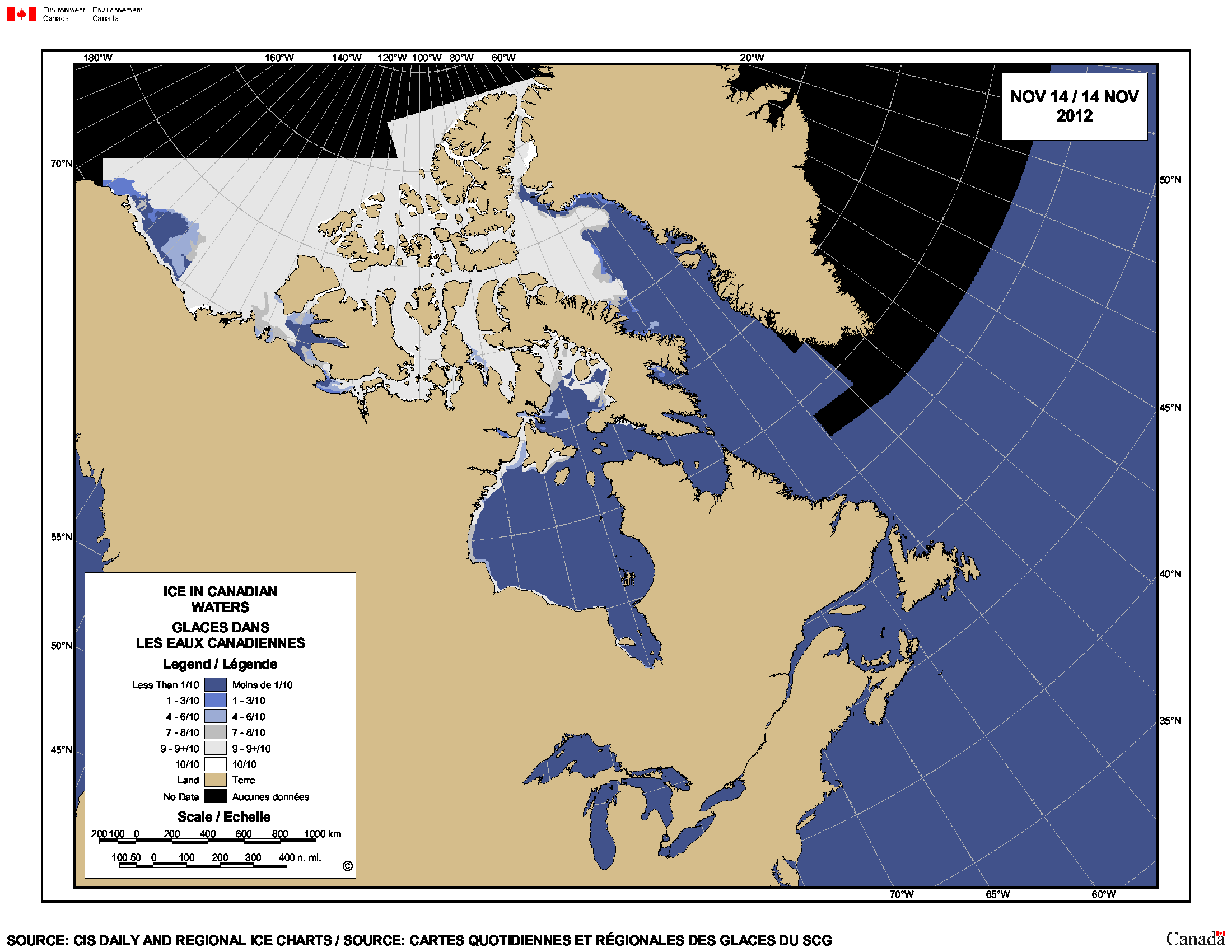
Figure 3. Sea ice concentration Canada 2013 at November 18, showing strong ice development in northwestern Hudson Bay. Polar bears were starting to leave the ice.
Figure 4. Sea ice concentration in 2012 at November 14, showing ice developing along northwestern Hudson Bay and in Foxe Basin. Bears were starting to leave the shore just north of Churchill by this date, which local informants said was about a week earlier than the year before (2011).
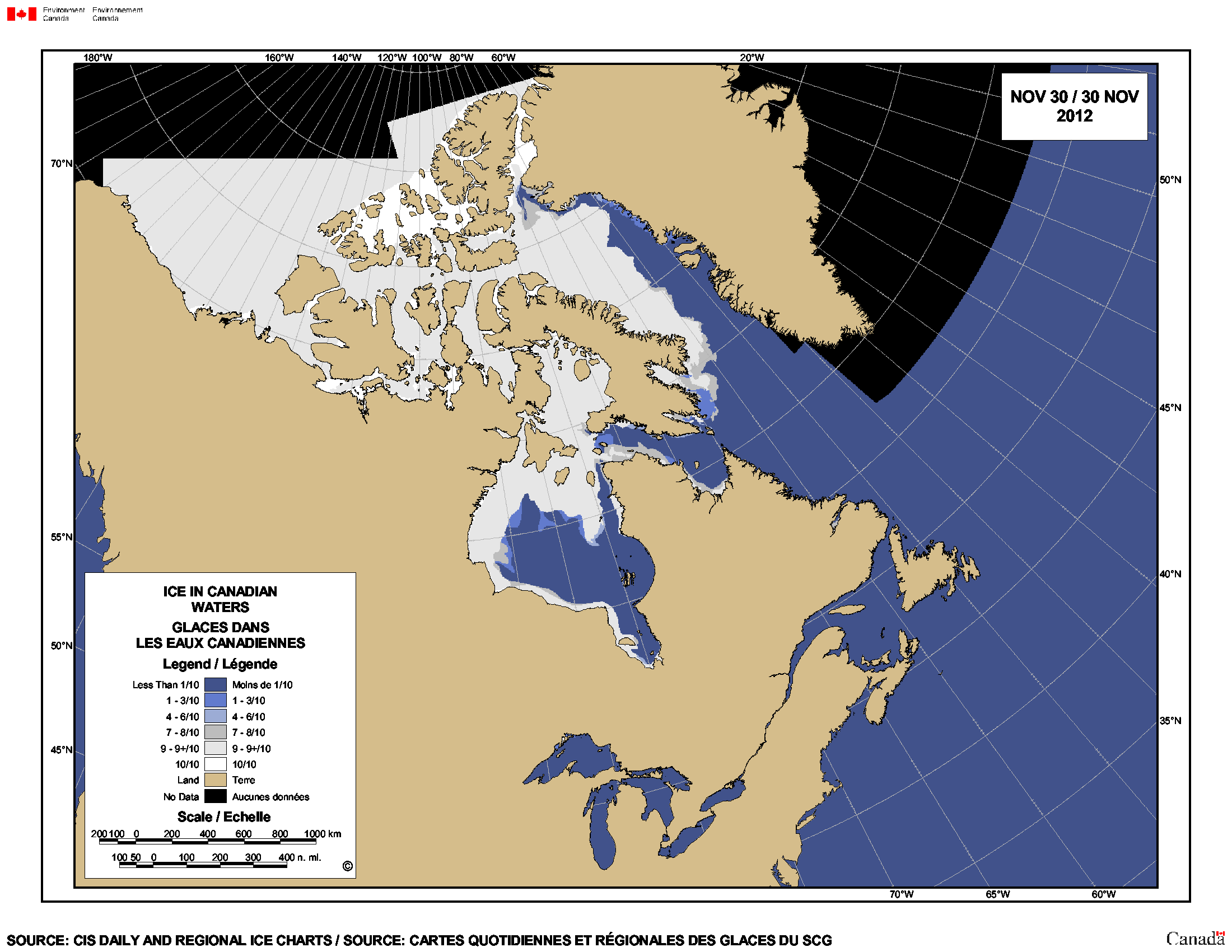
Figure 5. This is what the sea ice concentration looked like in 2012 at November 30. Note the extensive ice development in northwestern Hudson Bay and Foxe Basin. If polar bears had not left the shore well before this date in 2012, it wasn’t because they could not. All three maps from Canadian Ice Service.
References
Cherry, S.G., Derocher, A.E., Thiemann, G.W., Lunn, N.J. 2013. Migration phenology and seasonal fidelity of an Arctic marine predator in relation to sea ice dynamics. Journal of Animal Ecology 82(4):912-921.
http://onlinelibrary.wiley.com/doi/10.1111/1365-2656.12050/abstract


You must be logged in to post a comment.