Monthly Archives: May 2015

Global polar bear population size is about 26,000 (20,000-32,000), despite PBSG waffling

The IUCN Polar Bear Specialist Group admits its global population estimate is simply a qualified guess with a large potential error.  So perhaps it’s time to acknowledge that for the purpose of comparing polar bears to other species of concern, the upper limit for polar bear numbers worldwide could be more than 30,000?

Polar bears USFWS_cover PolarBearNews2013_2014

See previous posts on this global population size issue (here and here); updated information below, including the most recent IUCN PBSG statement.

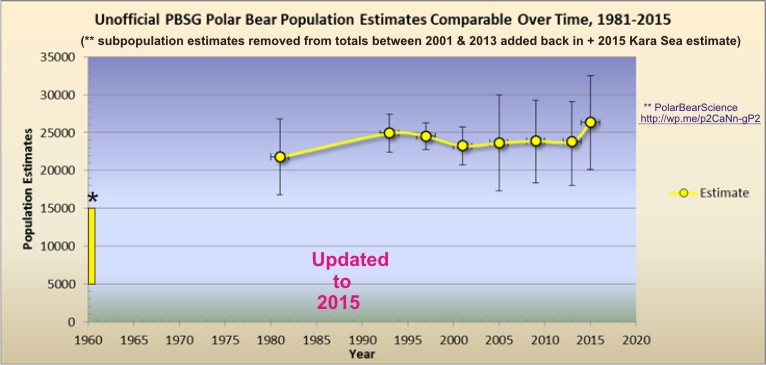
UPDATE 1 September 2015: here is an updated graph of polar bear population numbers that undo the “subtractions” of the PBSG between 2001 & 2013, giving a final global estimate of about 26,000. Click to enlarge:

Crockford unofficial polar bear numbers to 2015 Sept 1 FINAL

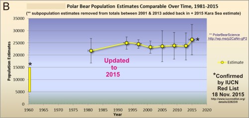
UPDATE 25 November 2015: The 2015 update of the IUCN Red List for polar bears essentially concurs with my assessment about polar bear numbers. They estimate the current global population is 20,000-31,000 (average of 25,500, see below, without considering the number of bears in the Arctic Basin, so not far off my assessment) but say the trend in the population is “Unknown.”

Crockford OFFICIAL polar bear numbers to 2015_IUCN concurrs Nov 18

UPDATE 23 February 2017: A new population estimate update is available based on three new survey counts that add about 2,000 bears to the average total, bringing it to almost 30,000 (28,500). Details here.

Continue reading

Hudson Bay sea ice coverage is atypical this year but what does that mean for polar bears?

Churchill_Polar_Bear_2004-11-15 Wikipedia

There is a rather large patch of open water in the northwest sector but what’s also unusual about breakup this year is the virtual lack of open water in eastern Hudson Bay – that almost never happens (compare to 2013 here). In addition, there’s still very little open water in Hudson Strait, which connects Hudson Bay to Davis Strait in the east – that’s also unusual.

Figure 1.  Sea ice extent over Hudson Bay and Hudson Strait at 26 May 2015. Canadian Ice Service.

Figure 1. Sea ice extent over Hudson Bay and Hudson Strait at 26 May 2015. Canadian Ice Service. Click to enlarge.

The question is: does the somewhat unusual pattern of ice cover at this date – which developed rapidly over the last few weeks – suggest we can predict whether polar bears will have a shorter-than-average hunting season?

To answer that, you have to look at maps generated by the same source over several years. The result, in my opinion, is inconclusive – while so far, this year looks a bit more like 2009 (which was a very late sea ice breakup year) than it does 2011 (which was an early breakup year), it’s really too early to tell.

I suggest we simply won’t know for another month or so which pattern will prevail. However, that hasn’t stopped IUCN Polar Bear Specialist Group member Andrew Derocher (via Twitter, e.g., here and here, among many others) from suggesting that this year’s pattern is likely a portend of doom for Hudson Bay polar bears. See what you think.
Continue reading

Arctic polynyas and sea ice extent in Canada at 20 May 2015

The map of sea ice extent in Canada at 20 May 2015 is an almost-perfect example of the placement of recurring patches of open water polynyas that were present in the Canadian Arctic at this time of year in 1975-1979. Notes from field work on shore leads in Hudson Bay ice at May, 1948 offer further insight into the current pattern of sea ice cover on the bay.

Polynyas and shore leads vs sea ice at 20 May 2015_PolarBearScience

May is traditionally the time when recurring polynyas in the Canadian Arctic become more prominent and persistent shore leads (cracks in the ice near shore, also called “flaw leads”) become wider. Polar bears hunt around these polynyas because ringed and bearded seals congregate around them in the spring (Stirling et al. 1981; Stirling 1997). These polynyas are often not truly “open water” but covered by thin ice that’s easy for seals to break through.

Slight differences in location and size of polynyas and shore leads from year to year (especially in spring) are governed primarily by prevailing winds (Dunbar 1981:29) and to a lesser extent, currents. See my previous discussion on Beaufort Sea polynyas, with references: Beaufort Sea polynyas open two weeks before 1975 – open water is good news for polar bears.

This suggests that while sea ice cover over Hudson Bay and the Beaufort Sea is now a bit below average for this time of year (as the maps for this week show), it does not necessarily portend an earlier breakup or longer open-water period later in the year.

Continue reading

University newspaper misleads readers on status of Western Hudson Bay polar bears

Even though polar bear experts admit there has been no trend in sea ice breakup or freeze-up dates since 2001 – and both Canadian and International experts say this subpopulation is stable – the public is still being misled about the status and condition of polar bears in Western Hudson Bay.

WHB status 2015 IUCN PBSG_PolarBearScience

The latest example of misinformation about Western Hudson Bay polar bears appears in a feature story carried by the campus newspaper of York University (Ontario, Canada), meant to highlight the work of biology graduate student Luana Sciullo.1
Continue reading

Polar bear habitat update: Hudson Bay sea ice breakup on track

Hudson Bay sea ice coverage is only slightly below average for this time of year (week of 14 May, below) but well above levels for 2006, when Western Hudson Bay breakup was relatively early).

Sea ice Canada 2015 May 14_CIS

Figure 1. Sea ice coverage over Hudson Bay for the week of 14 May, 1971-2015. Canadian Ice Service. Click to enlarge.

Figure 1. Sea ice coverage over Hudson Bay for the week of 14 May, 1971-2015. Canadian Ice Service. Click to enlarge.

Even at its highest extent in April, Hudson Bay is only 97-98% ice covered (due to persistent shoreleads and polynyas), which means ice levels are currently only 10% or so below maximum. In other words, there is still lots of polar bear hunting habitat over the bay.

That’s a bit lower than ice coverage was for the last two years at this date (2013-2014), which had average or above average ice cover. However, there is currently a bit more ice on Hudson Bay than there was in 2011 and 2012 – and much more than there was in 2010 and 2006.
Continue reading

Beaufort Sea polynyas open two weeks before 1975 – open water is good news for polar bears

With masses of very thick, multiyear ice off Alaska this spring, the developing polynyas (open water) at either end of the Beaufort Sea are providing essential polar bear hunting habitat.

SB polynyas on ice thickness map 14 May 2015_PolarBearScience

Patches of open water in the Beaufort Sea are naturally recurring phenomena. This year we have two excellent examples, shown by the yellow arrows in the sea ice thickness map above (from the Naval Research Laboratory).

The eastern-most polynya forms in the Canadian portion of the Beaufort most years in the spring. This open water feature is so common it has a name – the Cape Bathurst polynya. Last year, there wasn’t an obvious polynya there until sometime in June, but in 1975, a patch of open water almost as large (or larger) as this year’s had developed by the end of May (Fig. 1).

Figure 1. Cape Bathurst polynya at 28 May 1975 (Smith and Rigby 1981: Fig. 14h), with the extent probably underestimated, and the polynya this year at 14 May (Canadian Ice Service). Click to enlarge.

Figure 1. Cape Bathurst polynya at 28 May 1975 (Smith and Rigby 1981:Fig. 14h) and the polynya this year at 14 May (Canadian Ice Service). See discussion in the text below about the relative sizes. Click to enlarge.

According to the experts that study them, the timing and extent of the polynya formation depends on wind (Dunbar 1981:29), not temperature. This means that this spring’s polynya formation in the eastern Beaufort isn’t a symptom of global warming, it isn’t missing polar bear habitat,” and it isn’t a sign of early sea ice breakup.

In fact, the Cape Bathurst polynya is a critical place for ringed seals and bearded seals to congregate in spring. Therefore, this is where many Southern Beaufort polar bears go to hunt. The presence of the polynya is especially crucial in years like this one, when very thick sea ice covers most of the Beaufort Sea.  Continue reading

Snow depth over spring sea ice affects polar bear feeding success and ringed seal survival

Snow depth over sea ice in spring affects the hunting success of polar bears on ringed seal (Phoca hispida) pups, but the relationship is more complicated than you might think and there is less data on this phenomenon than you would believe.

Ringed seal lair_snow and ice thickness_PolarBearScience_sm

Regional snow depth in spring (April-May) varies naturally from year to year due to weather patterns driven in part by long-term climate cycles (like the Atlantic Multidecadal Oscillation, Pacific Decadal Oscillation, and the Arctic Oscillation).

This year, it was very cold in Eastern North America, with record-breaking snow fall in some areas. Snow depth was apparently greater than average over Hudson Bay sea ice this spring but was it deep enough to have impaired polar bear hunting success?

Continue reading

Labrador polar bear not lost or in danger – just running down a rural highway

An interesting report from Labrador this morning: video footage of a fat polar bear running down an isolated 2-lane highway in southern Labrador.

Cartright Junction_Labrador pb_Chelsea Morris photo from video

Yet another reminder that there is still a lot of sea ice off that coast, which is home to the Davis Strait polar bear subpopulation.
Continue reading

Polar bear habitat update – sea ice for hunting plentiful in all subpopulation regions

Preferred polar bear habitat is said to be 50% concentration or higher over continental shelves, which describes all but the fringes of sea ice extent today, including Hudson Bay, the Southern Beaufort, and the Barents Sea.

Preferred polar bear habitat 50pc concentration_May 8 2015_PolarBearScience

However, polar bears – excellent swimmers that they are – are quite capable of utilizing areas with 15-50% sea ice concentration if necessary (Durner et al. 2004; Rode et al. 2014:79), especially when prey are plentiful.  This would account for the fact that there are still sightings of polar bears in and around northern Newfoundland (see previous post here and photo below1), where ice concentration is in the 30-50% range.

Photo with this news story (7 May 2015): "(Update) Polar bear sighting in Croque"

Photo with this news story (7 May 2015): “(Update) Polar bear sighting in Croque”

Continue reading

Designated critical habitat for Alaskan polar bears offers no protection from thick spring ice deaths

The Obama administration is apparently attempting to overturn a previous ruling that rejected proposed Alaskan “critical habitat” for polar bears in 2013 – as if “critical habitat” would protect the bears from the repeated episodes of thick spring ice that develop in this region every 10 years or so.

Polar_Bear_male on sea ice_Alaska Katovik Regehr photo_April 29, 2005_sm labeled

According to a Reuters report today (5 May 2015):

Seeking to reverse a ruling throwing out its designation of critical habitat for polar bears, the Obama administration has defended its decision to list large swathes of the Arctic as necessary for the conservation of the threatened species.

A coalition of oil industry groups and Alaska Natives, represented by Stoel Rives and Holland & Hart, successfully persuaded the U.S. District Court for Alaska to vacate the government’s polar bear habitat designation in 2013.” [my bold]

If they succeed, it would put most of the north coast of Alaska under special ESA rules, as the map below shows (click to enlarge).

Critical habitat Polar Bears US_NorthSlopeOrg map_labeled_PolarBearScience

As I commented previously, regarding the Obama administration’s recommendation to congress that they approve a proposed Arctic wildlife refuge area on Alaska’s North Slope, this move (if implemented) would not protect polar bears from the starvation deaths due to thick spring ice conditions that have occurred in this region for 2-3 years out of every 10 since 1960 at least.

The other issue is how much additional, biologically meaningful protection a critical habitat designation would provide for Southern Beaufort and Chukchi Sea polar bears – over and above that already provided by the Marine Mammal Protection Act.
Continue reading