
At this time of year, sea ice extent numbers are meaningless for polar bears. The extreme low September minimum of 2012 – when masses of polar bears didn’t die – showed rational people that this is true. Even the low 2007 summer extent, which hit earlier in the season than 2012, had little to no negative impact.
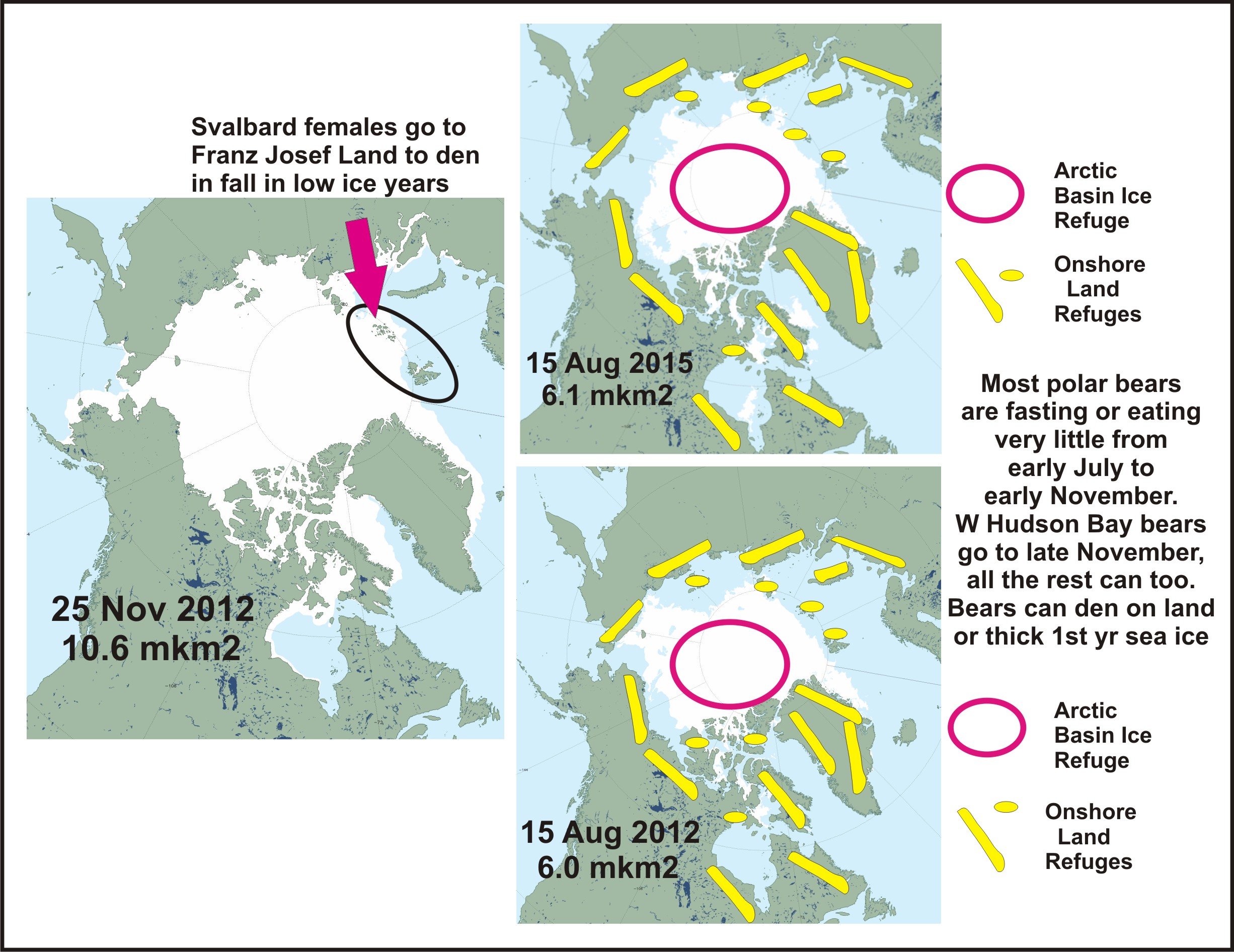
In late summer, bears outside the Canadian Archipelago either retreat to shore or stay on the sea ice as it retreats north into the Arctic Basin (see image below, click to enlarge). Most bears in the Archipelago have ice year round, so life doesn’t change much. This means that it does not matter to polar bears how much area the Arctic Basin ice covers in September – for their needs, 1.0 mkm2 would be plenty.
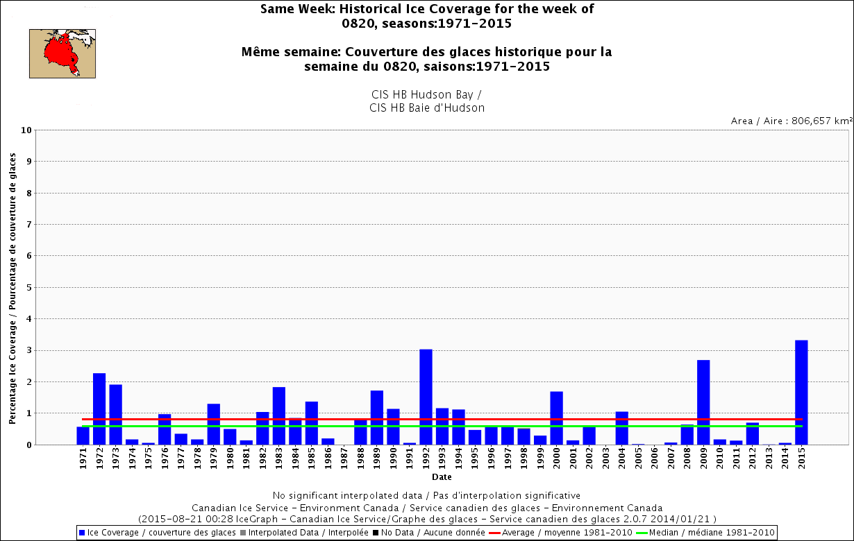
Still, Southern Hudson Bay polar bears had extended hunting opportunities in July this year (whether or not they hunted successfully) and for this date, Hudson Bay had more ice remaining than any year on record. Yes, more than even 1992 but only by a few percent. See charts and maps below.
Well-fed bears that spend the summer ice-free period onshore are not starving – they are fasting. The only bears that starve during the summer are those who have not fed enough during the spring – because they are unlucky, old, inexperienced, sick, etc. – will not. That’s life for a polar bear. Starvation is the leading cause of death and as far as we know, that has always been true.
That explains why most bears found onshore are not frantically seeking prey but curiously exploring for any easy morsel, and easily deterred. Many are generally relaxed, even lethargic, see picture below. There are always exceptions of course but life in the Arctic is not a teddy bear picnic – every year, some of the bears will die. Thin bears are seen occasionally but this is nothing new – it’s part of life.
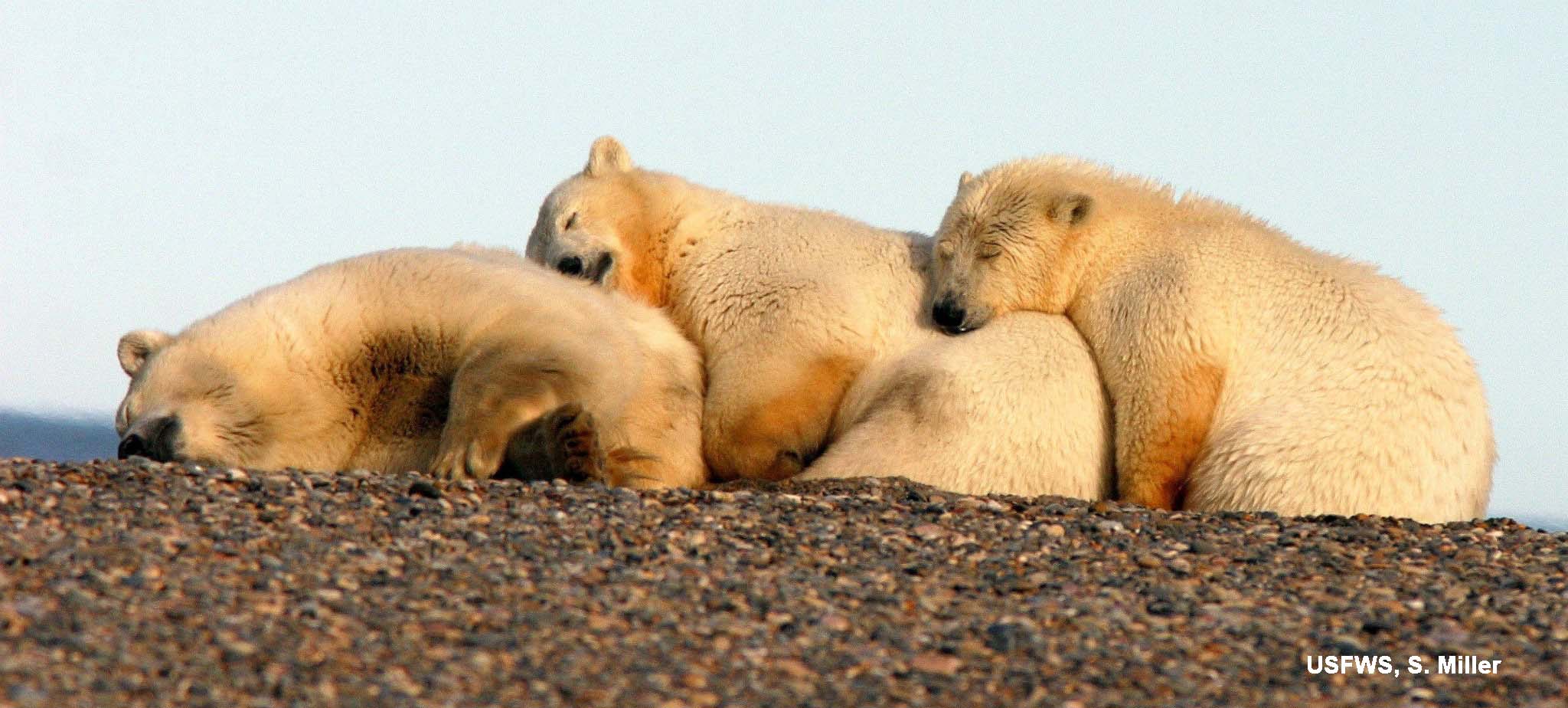
Southern Beaufort mother with cubs relaxes for the summer onshore.
Hudson Bay ice coverage for the week of 20 August 1971-2015 (note the scale on the left – all bars are indicating less than 4%), click to enlarge:
In other sea ice news, according to the latest NSIDC report, their Multisensor Analyzed Sea Ice Extent (MASIE) product “is more adept at detecting thin and deteriorating ice.”
See the comparison map I put together from the images they provided for ice extent at 16 August 2015, with the areas worth comparing marked in magenta:
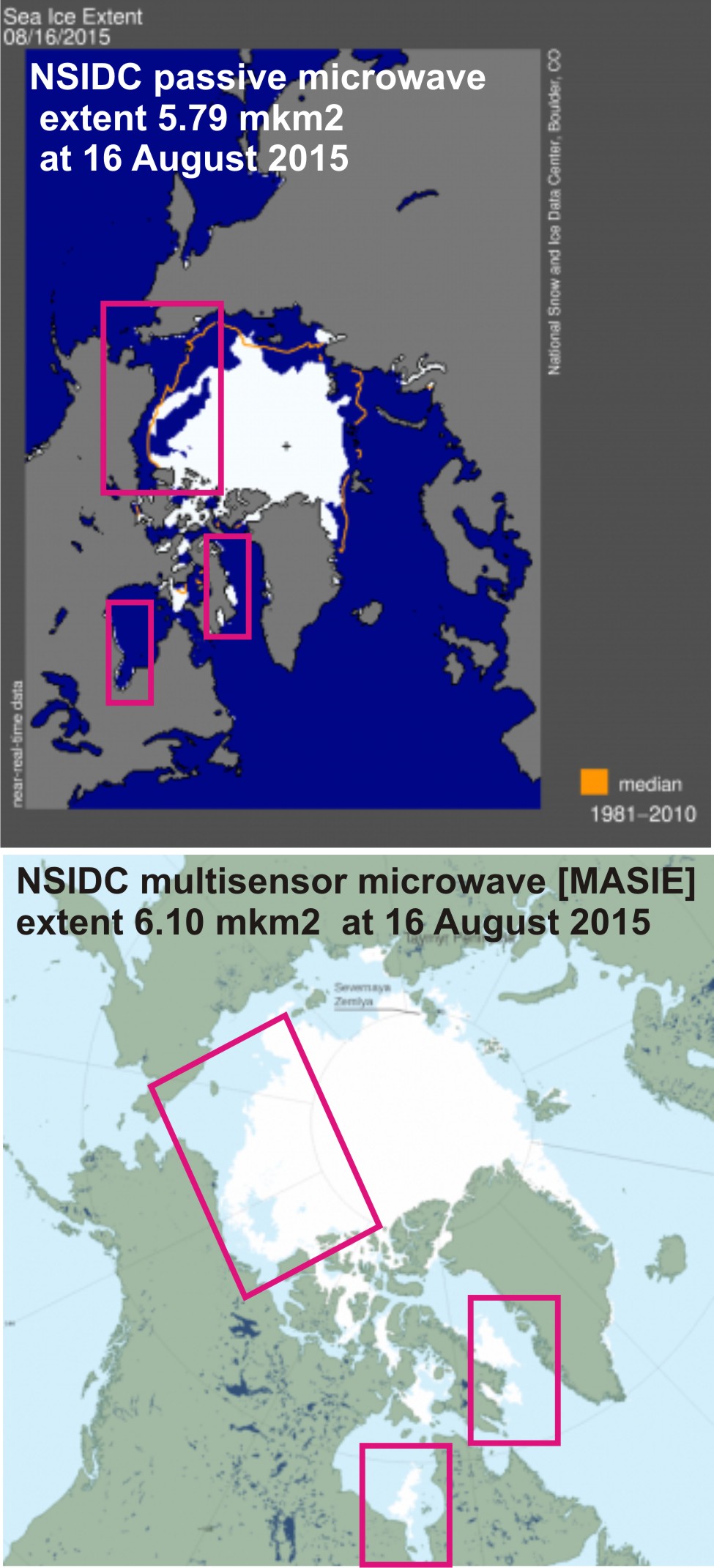
Here is what the folks at NSIDC had to say about the state of the sea ice at mid-August 2015 and the discrepancy between their passive microwave images (their standard blue and grey maps) and the MASIE images (light blue and green):
“Most of the ice in Baffin and Hudson bays has finally melted out. Large areas of open water and low concentration ice within the Beaufort and Chukchi seas continued to expand. Some of the low concentration ice depicted in the passive microwave data could be due to the presence of melt ponds on higher concentration ice. However, visible imagery from the Moderate Resolution Imaging Spectroradiometer (MODIS) sensor on the NASA Terra and Aqua satellites confirm a very loose ice pack with considerable open water in the region. Most of the remaining ice appears to be fairly thick multiyear floes interspersed by thinner first-year ice that is rapidly melting out. In the eastern Arctic, the ice pack remains more consolidated.”
“…the Northwest Passage still contains a considerable amount of ice. According to MASIE, there is as yet no completely open route. Some passive microwave products, such as from the University of Bremen’s Advanced Microwave Scanning Radiometer 2 (AMSR2), indicate an open water route along Norwegian explorer Roald Amundsen’s historical route through the southern part of the Archipelago. The apparent discrepancy between MASIE and the Bremen product is likely due to thin, heavily melting ice not detected by passive microwave imagery.”
So, passive microwave images are not so good at distinguishing melt ponds, which are a prominent characteristic of sea ice in the summer.
They say “thin” but remember – according to sea ice scientists “thin” ice is 30 cm to 120 cm, which is plenty thick enough to support a polar bear.
In 2012, there was 4.1 mkm2 ice remaining. And as I pointed out three years ago:
“Keep in mind that 4.1 mkm2 is about the size of Greenland (2.166 mkm2) plus Mexico (1.972 mkm2), or about the size of India (3.287 mkm2) plus Pakistan (0.809 mkm2).”
That’s lots of space for the bears that spend the summer in the Arctic Basin. Even the definition of an “ice-free” summer would leave just under 1.0 mkm2 of ice – an area larger than the size of Pakistan. That’s certainly enough room for a few thousand bears to spend a few weeks – because rest assured that the ice would not be that limited for very long before the sea begins to freeze again.


You must be logged in to post a comment.