
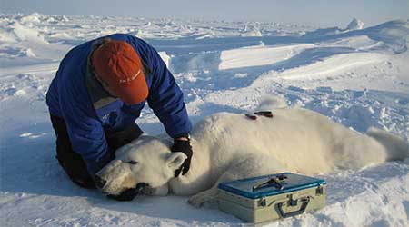
Five more bears were tagged near the Southern Beaufort Sea coast last month, all in the western portion of the coast where Chukchi Sea bears are often encountered. They join the one female who seems to have made a den way out over the continental shelf, where she’s been all winter.
This is the March 2016 follow-up to my post on the July 2013 track map for female polar bears being followed by satellite in the Beaufort Sea by the US Geological Survey (USGS) – “Ten out of ten polar bears being tracked this summer in the Beaufort Sea are on the ice.”
Five tagged bears are relatively few compared to eight last spring, and thirteen in 2013 [added to 7 from the previous year for a total of twenty, which were down to 13 by June] but the same as five tagged in 2014. This spring, three of the USGS tagged bears have glue-on transmitters, which means they are either males or juvenile bears rather than females (which are fitted with collars):
“In collaboration with the U.S. Fish and Wildlife Service we are also experimenting with glue-on and ear tag satellite transmitters, which can be deployed on adult male bears and younger, still-growing bears.”
See the map below – I see only four new icons near the coast near Barrow. But if you look closely (especially on the high resolution image at the USGS site), you can see that the ‘tail’ denoting the track of the bear with the bright pink icon is actually red, which means the red icon must be behind the pink one. The tracks of the blue and pink icons are obscured by the gold icon – you can see just the tip of the pink track peaking out at the base of the gold icon’s track]
“Movements of 6 satellite-tagged polar bears for the month of March, 2016. Polar bears were tagged in 2015 and 2016 on the spring-time sea ice of the southern Beaufort Sea. Three of these bears have satellite collar transmitters and 3 of these bears have glue-on satellite transmitters. Polar bear satellite telemetry data are shown with MODIS imagery from 31 March, 2016.” Original here (higher resolution). Note that the circles with the polar bear icons are the end points (final positions for the month), while the tail ends of the strings are the positions at the first of the month. Bright yellow icon far off the coast is from a female tagged last year who made a maternity den on the sea ice.
Sea ice thickness in the Beaufort Sea as of 8 April this year, according to NRLSSC (original here) is shown below:
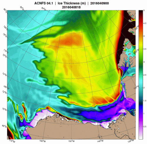
That’s a bit different than last year at this time, when there was thick, multi-year ice along the western portion of the coast and 2-3 m thick ice almost everywhere else:

Back in 2014, the pattern was different again, which shows how variable the ice can be in this part of the Arctic from one year to the next:


You must be logged in to post a comment.