
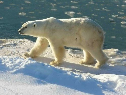
Breakup for Western Hudson Bay (WHB) is looking to be later than usual this year, given that the average breakup date since 1991 has been July 1 (using a 30% threshold) – only a few days from now – and the ice in WHB is nowhere near 50% coverage, let alone 30%.
Note that few WHB bears come off the ice around Churchill – most come ashore along the southwest coast of Hudson Bay (almost into SHB) and make their way north over the course of the summer to meet the ice as it reforms in the fall north around Churchill – that’s why it’s called a “migration.”
There’s still a lot of ice left in Hudson Bay, as the Canadian Ice Service map for 29 June 2016 (below) shows: 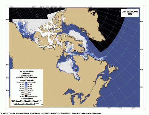
It seems to me that breakup for WHB this year is looking rather like 2014, which was something like a week later than the average since 1991, but time will tell. See below for comparison to 2009 (a late breakup year), 2015, and 2013 (lots of variability!), as well as a discussion of when bears come ashore in relation to this sea ice breakup benchmark.
2016 compared to previous years
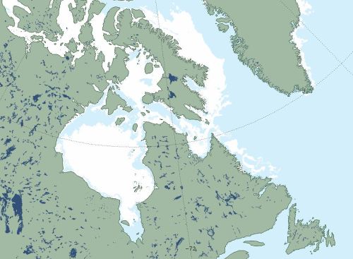
2016 at Day 180 below (28 June, because this is a leap year), cropped from NSIDC’s Maise sea ice chart. Note lack of ice off SE Greenland this year but plentiful ice off Labrador and in Hudson Strait:
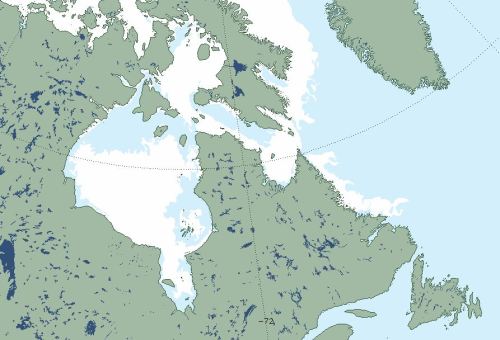
2016 Day 180
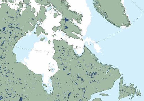
2009 at Day 180 below, when WHB breakup was at least 3 weeks later than usual and polar bears left the ice as late as they did in 1992 (the latest breakup date since 1979). Note how much ice remained in eastern Hudson Bay that year, which is very different from conditions this year (above):
2009 Day 180
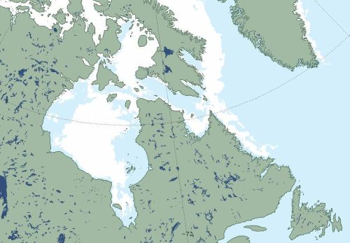
2015 at Day 180 below, when WHB breakup was very early (like 1990) because the ice cleared in the NW first, but Hudson Bay ice in the east and south (as well as in Hudson Strait) was very late breaking up, so many bears stayed on the ice and came ashore further south. Last year was a late breakup year for Southern Hudson Bay bears, many of whom stayed on the ice of eastern Hudson Bay until late July:
2015 Day 180
2013 at Day 180 below, a year when WHB breakup was about average. That was the year that a Sierra Club hiker got attacked by a polar bear in northern Labrador on July 24th (see my review of the book the attack spawned here and my published review from February 2015 here):
2013 Day 180
Where WHB bears leave the ice
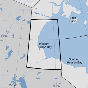
Most WHB bears leave the ice somewhere between Wakusp National Park south of Churchill and Polar Bear Provincial Park, along the southwest shore of Hudson Bay (see below, illustrated on a map from last year). That’s because the last remnants of ice usually concentrate there. However, some bears leave at preferred spots every year regardless of what the ice is doing:
Most bears leave the ice well after “breakup”
Cherry and colleagues (2013) studied WHB bears between 1991 and 2009 and stated:
“Throughout the study, bears arrived ashore a mean of 28.3 days (S.E. = 1.8) after 30% ice cover…”
That’s important to remember – just because that arbitrary sea ice coverage has been reached, the bears leave the ice when they are good and ready. Sometimes bears leave well before they really need to go ashore, and but they often stay four weeks or more after the ‘breakup’ point is reached.
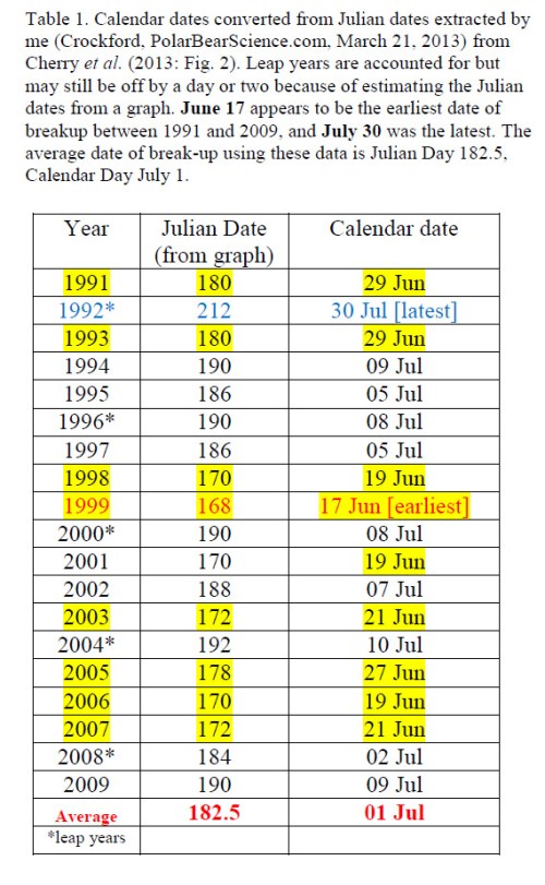
See the table I’ve constructed below of Cherry et al.’s breakup dates for 1991-2009:
30% ice cover in WHB this year
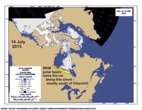
I’ve marked the ice chart from this year (28 June) below with the WHB boundaries used by Cherry and colleagues, to show how 30% ice cover might look (I’ve marked 50% for convenience). It’s clear the ice is nowhere near breakup in WHB.
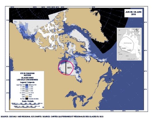
Canadian Ice Service chart for 28 June 2016 showing the Western Hudson Bay region used by Cherry and colleagues (2013) to calculate breakup dates relevant for polar bears, marked in dark pink. The map Cherry et al. used in their paper to define the region is added as an inset, upper right.
References
Cherry, S.G., Derocher, A.E., Thiemann, G.W., Lunn, N.J. 2013. Migration phenology and seasonal fidelity of an Arctic marine predator in relation to sea ice dynamics. Journal of Animal Ecology 82(4):912-921.
http://onlinelibrary.wiley.com/doi/10.1111/1365-2656.12050/abstract


You must be logged in to post a comment.