
In recent years, sea ice loss over Hudson Bay has begun with open water in the NW corner (which is just as likely due to prevailing offshore winds as ice melt) rather than along the east coast but this year that patch of ice is smaller than its been for the last two years. In addition, despite two patches of open water at either end of the Beaufort Sea, most of the coast of Alaska is still covered in thick ice — much more than existed last year, yet masses of polar bears did not die as far as I know (actually, WHB bears came ashore in excellent condition last year).
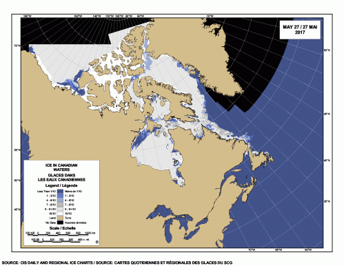
Compare to previous years:
Last year at 27 May (2016), where there was also more open water in the Beaufort Sea (driven not by melt but by the strong currents of the Beaufort Gyre) and in Kane Basin (between NW Greenland and Ellesmere Island):

27 May 2015 saw open water in NW Hudson Bay almost as far south as Churchill:

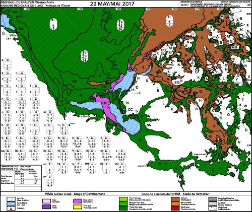
All of that dark green in the charts below is thick first year ice that’s at least 1.2 m thick and brown is ice >1 year old that is 2m thick or more.

 Polar bear biologist Andrew Derocher, who’s research team has been ear-tagging male WHB male polar bears in the NW sector this spring, confirms that the bears are drawn to the fragmented ice and edges of the open water in the NW where they are most likely to catch bearded seals.
https://twitter.com/AEDerocher/status/867076000101814273
Here is his plot of males (purple) and females (blue) at 24 May 2017:


You must be logged in to post a comment.