
Hudson Bay in early July this year is a mosaic of more-than-average and less-than-average sea ice coverage but apparently, only the less-than-average ice areas constitute the “early breakup” caused by climate change, and only “deniers” would say otherwise.

I say some folks are cherry picking the ice conditions that support a story line they prefer, forgetting that polar bears know better than they do when to come in off the ice.
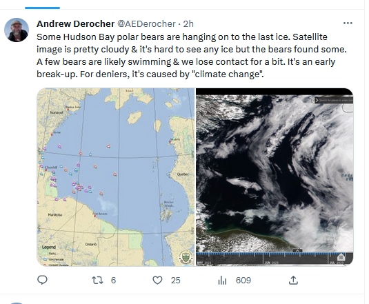
Out of 40 males or young bears with ear tags (purple) or collared females (red and blue) captured in Western Hudson Bay in the last year shown on this map at 7 July 2023, 16 or 40% were onshore (one very far inland), while 24 or 60% were still out on what appears to be very little ice.

According to a tweet on 8 July by Andrew Derocher, who is in charge of attaching many of those tags, that 60% constitutes only “some” polar bears.
How much ice is there?
He also says it’s “hard to see any ice” on the satellite image he provides but if you look at more informative charts, it’s apparent there is actually a fair amount of ice present. Even two days later, at 9 July, there was enough ice to support any bear that wanted to stay offshore for a while longer.

The weekly ice chart below, taken a few days before the bear tag map, shows very thick ice remaining over the bay at 3 July. At this time of year, ice may be covered in melt water, which confuses the satellites into interpreting it as low concentration ice or open water (Castro de la Guardia et al. 2017). This “ponding” effect is a real, known source of measuring error for sea ice during breakup and Andrew Derocher knows this (or should) — but it’s not what he tells the public.
In general, passive microwave derived sea ice data are associated with an underestimation error of up to 30% during breakup and freeze-up throughout the marginal ice zone and seasonal ice regions in the Northern Hemisphere. In Hudson Bay, passive microwave sea ice concentration can underestimate sea ice concentration by up to 50% compared with CISDA. Underestimation biases of passive microwave data are associated with the presence of wet snow and melt ponds during breakup… [Castro de la Guardia et al. 2017:227, my bold]

Big climate change cherry pick
In the weekly ice anomaly chart below, red is less than average but blue is more than average. If the red areas in central and western Hudson Bay are forcing polar bears ashore early because of “climate change” (as per Derocher tweet, above), what’s causing southern Hudson Bay, Hudson Strait, Labrador Sea and Davis Strait to have more than average ice coverage? Do Western Hudson Bay polar bears really suffer harm due to global climate change at the very same time that Southern Hudson Bay and southern Davis Strait bears thrive in better-than-the-1980s conditions, even though some of them live further south? That sounds more like a big game of climate change picking-of-cherries than a scientific assessment of fact.

Here’s a question: If something on the order of 40-50% of Western Hudson Bay polar bears don’t come ashore until the very last bits of sea ice are truly melted in summer (e.g., in 2020, 45% of tagged bears were still offshore when only a small remnant block of ice remained), is any definition of breakup based on a particular percentage of sea ice coverage of any use in describing when these bears come ashore? Or is this definition still used because it’s particularly useful for creating scary-sounding headlines to support the human-caused climate change agenda and the polar-bears-are-all-going-to-die narrative?
I suggest polar bears, due to their evolutionary history, are simply more flexible in their relationship to sea ice than polar bear experts have concluded based on limited evidence, and that the bears don’t actually need to come ashore until the last of the ice is gone. As long as they are in good condition after a successful spring hunting season, it probably doesn’t matter whether W Hudson Bay polar bears come ashore in June or August.
References
Castro de la Guardia, L., Myers, P.G., Derocher, A.E., et al. 2017. Sea ice cycle in western Hudson Bay, Canada, from a polar bear perspective. Marine Ecology Progress Series 564: 225–233. http://www.int-res.com/abstracts/meps/v564/p225-233/


You must be logged in to post a comment.