Tag Archives: ice charts

Natural flexibility explains W Hudson Bay polar bear movements at breakup better than climate change

Hudson Bay in early July this year is a mosaic of more-than-average and less-than-average sea ice coverage but apparently, only the less-than-average ice areas constitute the “early breakup” caused by climate change, and only “deniers” would say otherwise.

I say some folks are cherry picking the ice conditions that support a story line they prefer, forgetting that polar bears know better than they do when to come in off the ice.

Continue reading

Most Hudson Bay polar bears are still offshore, excellent ice conditions for late July

With only a few days until the end of July, most Western Hudson Bay polar bears are still on a thick band of thick first year ice that remains close to shore. The few bears that have come off the ice appear to be nice and fat, indicating they had good spring feeding conditions.

Untagged bear with cub, near Churchill River, 18 July 2022

We’ll have to wait a few more weeks to see if this year shapes up as it did in 2020, when the last of bears didn’t come ashore until the third week of August, despite there being very little visible ice. Last year, most of the bears were ashore by the end of July.

Continue reading

Polynyas are critical for polar bear spring feeding

Areas of open water or thin ice in spring are essential for the survival of Arctic species, as I emphasized in my recent peer-reviewed paper on polar bear ecology. Sea ice is still abundant in spring (April-June), which is the critical feeding period for polar bears: they must consume about 2/3 of the total calories they need for the entire year. Most of those calories come from newborn seals (ringed, bearded, and harp).

In southern areas, such as Hudson Bay and Davis Strait, virtually all of this feeding is completed by the end of May, making June a time of opportunistic hunting for most bears: if they find a seal, they will kill and eat it but if not, they can do without. That’s not just my opinion but the reason given by polar bear specialists themselves to explain why Southern Hudson Bay polar bear numbers had not declined in the 2000s despite a sudden increase in the ice-free season:

…even though break-up has advanced by up to 3-4 weeks in portions of Hudson Bay it still occurs no earlier than late June or early July so does not yet interfere with opportunities to feed on neonate ringed seal pups that are born in March-April in eastern Hudson Bay. Therefore, losing days or weeks of hunting opportunities during June and July deprives polar bears of the opportunity to feed on adult seals, but does not deprive them of the critical spring period when they are truly hyperphagic. [Obbard et al. 2016:29]

Continue reading

W Hudson Bay polar bears won’t have an early breakup year, according to sea ice charts

There is still a huge swath of highly concentrated thick first year ice (>1.2m) over most of Hudson Bay this week (19 June 2017) and even in the NW quadrant (the closest proxy we have for Western Hudson Bay), the weekly graph shows levels are greater than 2016, when WHB bears came off the ice in good condition about mid-July. All of which indicates 2017 won’t be an early sea ice breakup year for WHB polar bears.

Hudson Bay weekly ice stage of development 2017 June 19

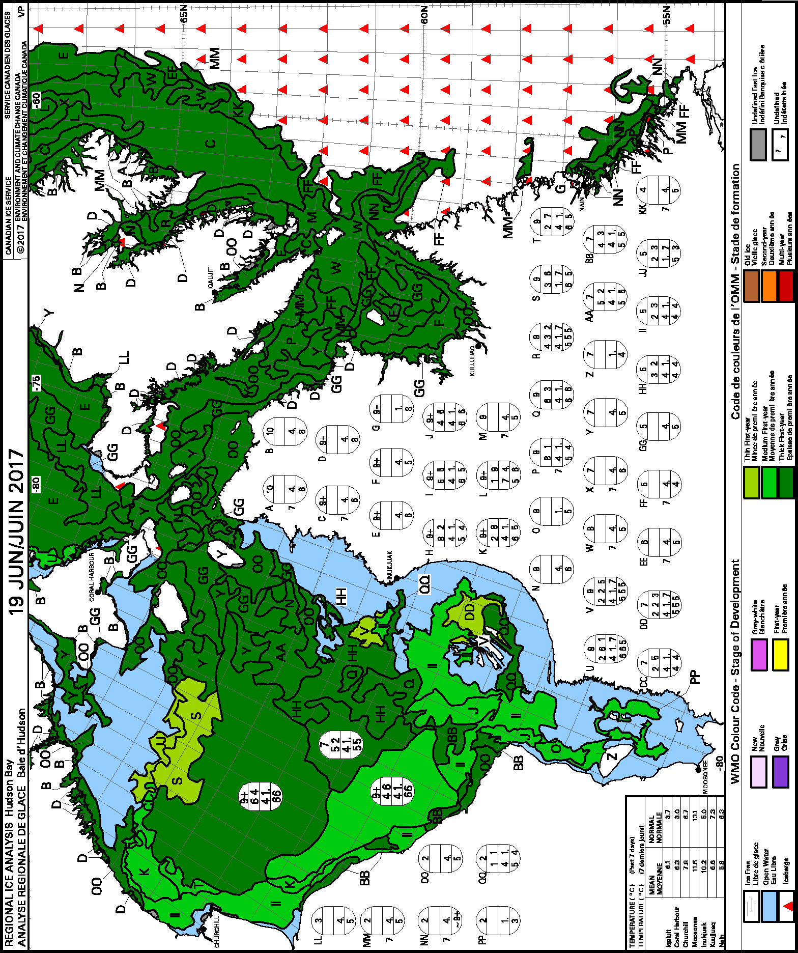
There is thick first year ice (>1.2m, dark green) in patches along the west coast in the north and south. Thick first year ice also extends into Hudson Strait and Baffin Bay, with some medium first year ice (0.7-1.2m thick, bright green) along the central and southern coasts of WHB.  Note the red triangles incorporated into the thick ice of Hudson Strait in the chart above: those are icebergs from Greenland and/or Baffin Island glaciers. A similar phenomenon has been noted this year off northern Newfoundland, where very thick glacier ice became mixed with thick first year pack ice and were compacted against the shore by storm winds to create patches of sea ice 5-8 m thick.

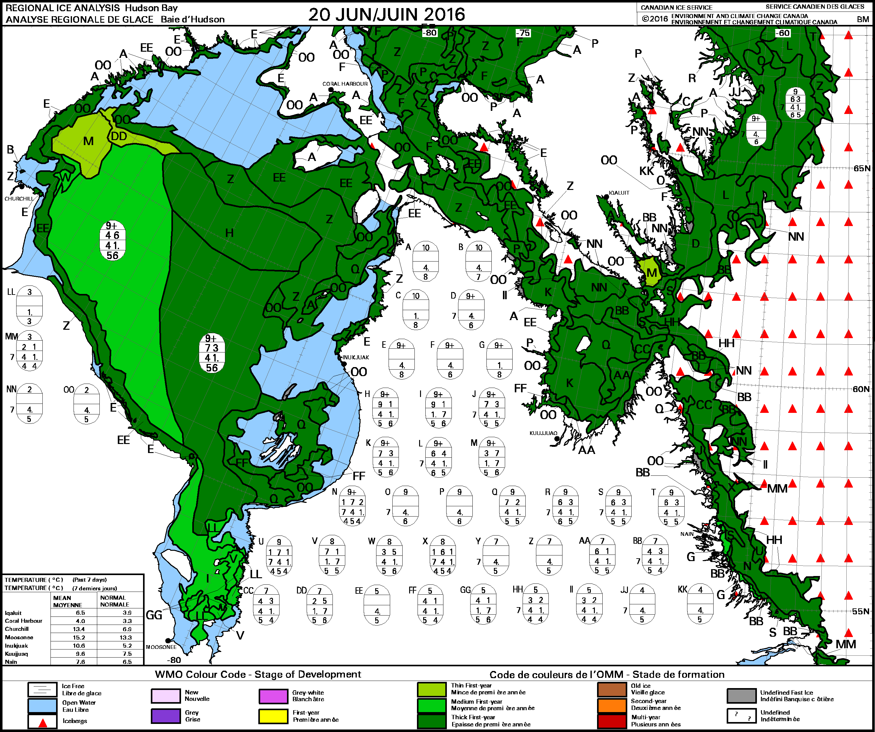
Compare the above to what the ice looked like last year at this time (2016 20 June, below). There is more open water in the east this year (where few WHB bears would likely venture anyway) but less open water around Churchill and Wapusk National Park to the south than there was in 2016:

Hudson Bay ice age weekly at 20 June 2016

We won’t know for several more weeks if most WHB bears will come ashore at about the same time as last year (early to mid-July) or whether they will be in as good condition as they were last year (because winter conditions may not have been similar).

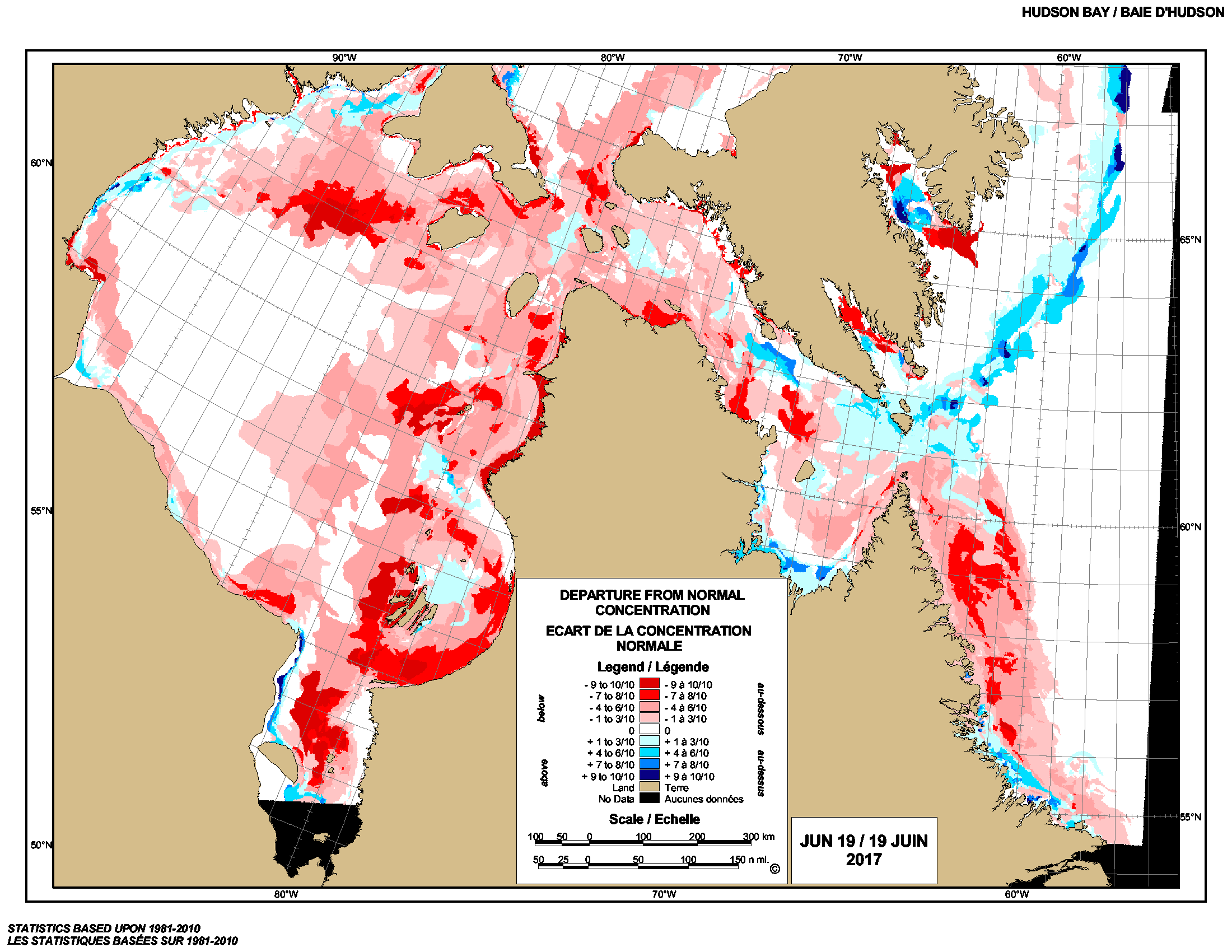
But so far, sea ice conditions are not looking as dire as the weekly “departure from normal” chart (below, 19 June 2017) might suggest (all that “less than normal” red and pink, oh no!!):

Hudson Bay weekly departure from normal 2017 June 19 Continue reading

Breakup date average for W. Hudson Bay is July 1 – this year, it’s late again

In the last few days, ice coverage on Western Hudson Bay finally dropped below the 30% level that now defines ‘breakup’ for polar bears: a few bears near Churchill started to come ashore late last week but most will stay on the ice until the end of July. That means breakup this year was unofficially July 8th, a week later than average (July 1) for the third year in a row.
Sea ice extent Canada 2014 July 7 CIS

Don’t’ tell that to the folks at Polar Bears International, though, because they’re busy telling people that the ice-free season for Western Hudson Bay bears is now longer than it was before the 1990s. What they mean is that the overall trend is toward early breakup dates.

But what they don’t admit is that over the last 44 years, breakup was a full two weeks earlier than average for Western Hudson Bay only six times and only three of those early breakups occurred within the last 13 years. See the calculations below and see what you think.

Continue reading