Tag Archives: Bering Sea

Buffet time for polar bears – spring/early summer is for eating baby seals

Spring is the busiest and most important season for polar bears: it is the most important feeding period and it is also when mating occurs. The fat that polar bears put on during the spring and early summer is critical for their survival over the rest of the year and for females, determines whether they can successfully produce cubs the following year.

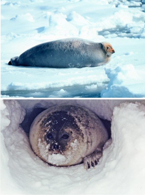
Mothers and new cubs emerge from their winter dens in late March to early April and those who have chosen to den on land soon head towards the sea ice. For a fabulous photo of a polar bear female and her two young cubs, just out of their winter den, feeding on a bearded seal pup, pop over here. All other bears, including females with older cubs, will already be on the ice, feeding on the first newborn ice seals of the season and any other seals they can catch.

It’s buffet time for polar bears but the most dangerous time for cute baby seals. Continue reading

New Chukchi Sea polar bear survey – exciting preliminary results

Back in October, I wrote about US Fish & Wildlife biologist Eric Regehr comments about a recent survey of Chukchi Sea polar bears, the results of which are still not published. Since then, I’ve been able to track down a bit of information.

This project appears to have run for five years, from 2008 to 2011. The work was confined to the eastern (US) portion of the Chukchi, see maps below (Polar Bear News 2010; Rode and Regehr 2010). Researchers were doing mark-recapture work with helicopters, putting radio collars on some females and radio ear tags on a few males. They worked primarily in March and April (mating season for polar bears), operating entirely on the offshore sea ice – working, I might add, on bears that technically speaking do not exist, since the official population estimate for this region is “zero” (they are not included in the global estimate of 20,000-25,000, see pdf here,, discussed here).

Figure 1. Chukchi Sea – getting you oriented. Note the location of Kotzebue Sound, northeast of the Bering Strait. Map from Wikipedia.

Figure 1. Chukchi Sea – getting you oriented. Note the location of Kotzebue Sound, northeast of the Bering Strait. Map from Wikipedia.

In 2012, US Fish & Wildlife biologist Eric Regehr told reporter Jill Burke at Alaska Dispatch that they found the bears were “reproducing well and maintaining good body condition.” I’ve finally found some details regarding what he meant by that statement (although no final reports or peer-reviewed papers are out, see footnote below).

Continue reading

Goldilocks in the Bering Sea: Less sea ice is bad and more ice is bad

This article from yesterday about sea ice in the Bering Sea is priceless: while we are still being told that below average ice coverage (common 10-20 years ago) is a sign of global warming that means the end of polar bears sometime in the future, it turns out that too much ice is bad, less ice is friendlier and lots of ice is hopefully something that we’ll never see again.

From the article:

After a 2012 Bering Sea snow crab season that saw unusually severe sea ice inhibit fishermen’s efforts to catch almost 89 million pounds of the shellfish, 2013 is shaping up to be much friendlier.

According to Kathleen Cole, a forecaster with the National Weather Service ice desk, this winter was unlikely to match 2012, even before it began. Despite some recent rumors of encroaching ice into the Bering Sea fishery, the situation is better than last year, she said.

“We’re just not going to have a year like last year. It’s going to be, by no means, that bad,” she said. “Last year was something that we’d never seen before, and hopefully something that we’ll never see again.”

Sea ice is still well above average in the Bering Sea this year – as it has been for 7 of the last 10 years. See the ice extent map from NSIDC from yesterday below and my previous post from December 2012: Now that Bering Sea ice cover is high again, variability is normal (note that polar bears of the Bering Sea are considered part of the “Chukchi Sea” subpopulation, which we know practically nothing about, see previous post here). Continue reading

Extirpated polar bears of St. Matthew Island spent five months on land during the summer

Did you know there used to be resident polar bears on two small islands in the Bering Sea? Given how much we don’t know about the polar bears of the Bering Sea, the bears that used to den and spend their summers on the St. Matthew Islands are a bright spot. These islands lay at the southern-most limit of the modern “Chukchi Sea” subpopulation (see Fig. 1) and were uninhabited by people when they were discovered in the 1760s – but they were a haven for polar bears.

We have details of the polar bears that gave birth and summered there because a US government biologist (Henry Wood Elliott) and a US navy Lieutenant (Washburn Maynard) surveyed the islands in 1874. Elliott wrote both an official report and a popular magazine article (for Harper’s Weekly Journal of Civilization) in 1875 describing the polar bears they saw; Maynard wrote a separate report in 1876. By 1899, there were none left, victims of the relentless slaughter of polar bears everywhere in the Arctic in that era (see previous discussion here).

Figure 1. St. Matthew Island is in the Bering Sea off the west coast of Alaska: north of the Pribilofs and south of St. Lawrence Island, at about 60°N latitude. Compare this to the southern end of James Bay, Canada – which has a stable population of polar bears – at about 53 0N and Churchill, Manitoba – the “polar bear capital of the world” – at 58 046’N. Maps from Wikipedia.

Figure 1. St. Matthew Island is in the Bering Sea off the west coast of Alaska at about 60°N latitude. Compare this to the southern end of James Bay, Canada (which has a stable population of polar bears) at about 53 0N and Churchill, Manitoba (the so-called “polar bear capital of the world) at 58 046’N. Maps from Wikipedia.

Figure 2. A drawing of polar bears on St. Matthew Island that accompanied the May 1, 1875 Harper’s Weekly Journal of Civilization article written by Henry Elliot. See here.

Figure 2. A drawing of polar bears on St. Matthew Island that accompanied the May 1, 1875 Harper’s Weekly Journal of Civilization article written by Henry Elliot. See here.

[UPDATE: Jan. 27, 2013: a follow-up to this post is here.]

Continue reading

Bearded and ringed seals join the polar bear as “threatened” by a computer-modeled future

As I pointed out in Featured Quote #22 (posted on Dec. 23, 2012), bearded and ringed seals have recently joined the polar bear on the American ESA’s list of animals that are “threatened” by computer-modeled predictions of Arctic sea ice declines projected 50-100 years into the future (USFWS 2008, 2012a, 2012b).

NOAA photos of bearded seal (top) and ringed seal (bottom)

NOAA photos of bearded seal (top) and ringed seal (bottom). The bearded seal is one of the largest Arctic ice seal while the ringed seal is the smallest. Both are eaten by polar bears, although ringed seals are consumed most often.

The decision by NOAA (National Oceanographic and Atmospheric Administration) affects the Arctic subspecies of ringed seal (Phoca hispida hispida) as well as the Okhotsk subspecies (Phoca hispida ochotensis) (in addition to several others) and thus includes all ringed seals off Alaska’s coast in the Beaufort, Chukchi and Bering Seas. The decision also affects two particular subpopulations of bearded seal (Erignatha barbatus): the “Beringia” [Bering Sea/Chukchi] subpopulation (about half of which reside in Alaskan waters), and the subpopulation that lives in the Sea of Okhotsk. (Alaska Fisheries (NOAA) Final Decision). Continue reading

Now that Bering Sea ice cover is high again, variability is normal

Sea ice development in the Bering Sea is trending higher than average again this year, even though it is early in the season. The NSIDC sea ice extent image for Dec 6 2012 below (Fig. 1) shows extensive ice development in the Bering Sea. [courtesy WUWT sea ice reference page]

Seven of the last 10 years have produced above-average freezing in the waters west of Alaska” says Kathleen Cole of the Alaska National Weather Service (Dec. 6, 2012) – see “Featured Quote” #20 in the right column (also filed in the “Quote Archive“).

Fig. 1 National Snow and Ice Data Center (NSIDC) sea ice extent at Dec. 6 2012. The orange line is the median extent for this date for 1979-2000.

Figure 1. NSIDC sea ice extent at Dec. 6 2012.
The orange line is the median extent for this date for 1979-2000. Click to enlarge.

The NSIDC, in their report on the annual freeze-up of the Arctic (November 2012), have this to say about the ice in the Bering Sea:

“…ice extent in the Bering Sea by the end of the month was greater than average, continuing a pattern seen in recent years. Extent in the Bering Sea was at record high levels last winter.”
Continue reading