
On Monday, March 25, the National Snow and Ice Data Center (NSIDC) announced that March 15 2013 was likely the maximum extent reached this winter. Note that just a few days ago, I discussed the relationship between maximum extent of sea ice and the global distribution of polar bears around the Arctic (see March 20th post here).
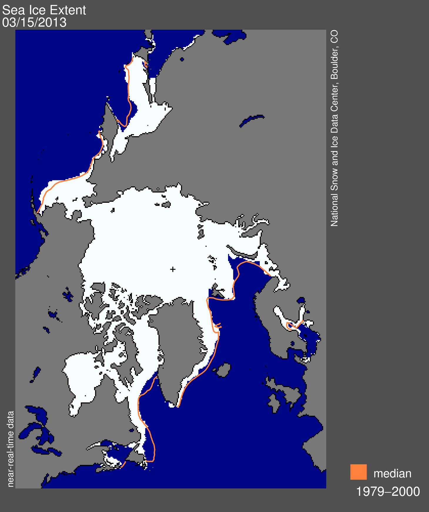
NSIDC says: “Arctic sea ice extent on March 15 was 15.13 million square kilometers (5.84 million square miles). The orange line shows the 1979 to 2000 median extent for that day. The black cross indicates the geographic North Pole.” Click to enlarge.
NSIDC say:
On March 15, 2013 Arctic sea ice likely reached its maximum extent for the year, at 15.13 million square kilometers (5.84 million square miles). The maximum extent was 733,000 square kilometers (283,000 square miles) below the 1979 to 2000 average of 15.86 million square kilometers (6.12 million square miles). The maximum occurred five days later than the 1979 to 2000 average date of March 10. The date of the maximum has varied considerably over the years, with the earliest maximum in the satellite record occurring as early as February 24 in 1996 and as late as April 2 in 2010.
This year’s maximum ice extent was the sixth lowest in the satellite record. The lowest maximum extent occurred in 2011. The ten lowest maximums in the satellite record have occurred in the last ten years, 2004 to 2013. [my bold]
And also:
Over the 2012 to 2013 winter season, sea ice extent grew a record 11.72 million square kilometers (4.53 million square miles). The record growth was primarily a result of the record low minimum last September, leaving a greater extent of ocean surface uncovered in ice to re-freeze this winter. This seasonal ice gain is 645,000 square kilometers (249,000 square miles) higher than the previous record (2007 to 2008) and 2.63 million square kilometer (1.02 million square miles) higher than the 1979 to 2000 average. Last autumn’s record low and this winter’s record ice growth indicate a more pronounced seasonal cycle in Arctic sea ice and the increasing dominance of first-year ice in the Arctic. [my bold]
More first year ice? That sounds like good news for polar bears and ringed seals, see previous posts here and here.
According to NSIDC:
new ice is < 10cm thick
young ice is 10-30cm thick (30cm is about 1 foot)
thin first year ice is 30-120cm (0.3-1.2m) thick
thick first year ice is 120-200cm (1.2-2.0m) thick or more.
Note that none of this information from NSIDC about ice extent tells us anything about the thickness of shorefast ice around the Arctic, which if it gets too thick, can cause local devastation for polar bear females and their newborn cubs (see previous post here). You’ll notice also that one of the places the ice is exceptionally low this year is around Newfoundland and the Gulf of St. Lawrence – good news for shipping and may be good news for folks in Newfoundland watching out for polar bear visitors playing havoc.
See the entire NSIDC report here and related story from Alaska Dispatch (March 26) here.


You must be logged in to post a comment.