
Here is the July 2014 follow-up to my post on the July 2013 track map for female polar bears being followed by satellite in the Beaufort Sea by the US Geological Survey (USGS) – “Ten out of ten polar bears being tracked this summer in the Beaufort Sea are on the ice.”
See that post for methods and other background on this topic, and some track maps from 2012 (also available at the USGS website here).
The USGS track map July 2004 is copied below (Fig. 1).
Compare this to June’s map (Fig. 4). The 20 bears from May (down to 14 in June) are now down to 13. All seven of the bears outfitted with glue-on satellite transmitters in April [either males or subadult animals] have either moved out of the area or their tags have fallen off or stopped transmitting. This means that all of the bears shown on the June and July maps below are females.
One bear has moved into Canadian territory and another is well into the Chukchi Sea. This is now known to be a typical rather than unusual phenomenon, and is pertinent to the bigger picture of what constitutes a discrete geographic subpopulation for polar bears.
Figure 1. From original caption: “Movements of 13 satellite-tagged polar bears for the month of July, 2014. Polar bears were tagged in 2014 on the spring-time sea ice of the southern Beaufort Sea. All thirteen of these bears have satellite collar transmitters. Polar bear satellite telemetry data are shown with MODIS imagery from 29 July, 2014.” Note that some of the white areas on the right (along Alaska coast) are clouds, not sea ice (see Fig. 2 below); also, one bear is now in Canadian territory and one is in the Chukchi Sea (see Fig 3 below). Click to enlarge, original image here.

Figure 2. Sea ice extent map for July 29, 2014 without the cloud cover of Fig. 1. Courtesy NSIDC, Arctic Sea Ice News.
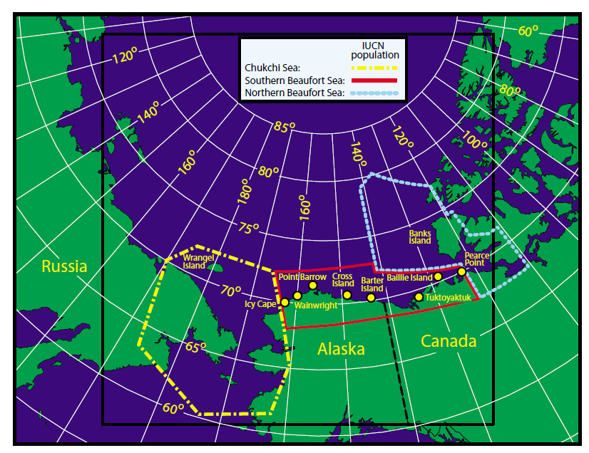
Figure 3. From the paper by Amstrup and colleagues (2005) describing the effect that movement of bears across subpopulation boundaries has on setting harvest quotas and population estimates. Southern Beaufort (SB) boundary is solid red, Chukchi Sea (CS) is dashed yellow and Northern Beaufort (NB) is dotted light blue. “Point Barrow” is Barrow, AK (well inside the SB boundary). From previous post here.
Figure 4. June 2014 track map. Fourteen bears visible; “satellite telemetry data are shown with MODIS [sea ice] imagery from 21 June, 2014.” Click to enlarge.
“…the PBSG definitions of 19 subpopulations are not consistent with the IUCN, where subpopulation refers to a geographically or otherwise distinct group.” Pg. 16
…
“A number of unresolved issues remain [with subpopulation boundaries] – many of the current boundaries are arbitrary and don’t make sense, some subpopulations overlap, and the general public view populations differently.” Pg. 20 [my bold]
Nice to see the collared bears confirm these assertions for all to see.
Related posts:
Southern Beaufort polar bear ‘decline’ and reduced cub survival touted in 2008 was invalid, PBSG now admits March 24, 2014
Chukchi/Bering Sea ringed seals doing better despite declines in ice and snow: new study July 11, 2013
Chukchi-Beaufort sea ice atlas: check out polar bear habitat 1850-2013 February 19, 2014
Polar bear-sea ice relationships – what biologists knew in ‘72 March 31, 2013
Polar bears move around as sea ice habitat changes – this is what resilience looks like April 14, 2014
References
Amstrup, S.C., Durner, G. M., Stirling, I. and McDonald, T. L. 2005. Allocating harvests among polar bear stocks in the Beaufort Sea. Arctic 58:247-259. http://arctic.journalhosting.ucalgary.ca/arctic/index.php/arctic/article/view/426
Pdf here.


You must be logged in to post a comment.