Tag Archives: polar bear movements

Same amount of sea ice for Hudson Bay polar bears as 2013, bears still on the ice

Sea ice coverage for Hudson Bay on 14 June converged on levels recorded in 2013, when breakup was slightly later than the average of the last two decades.

r10_Hudson_Bay_ts

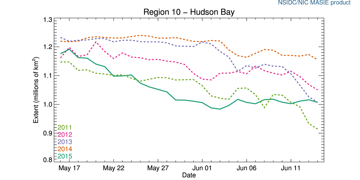
There is also more ice over Hudson Bay than there was in 2011, which was an early breakup year (charts for other Arctic regions here, originals here).

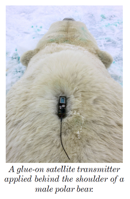
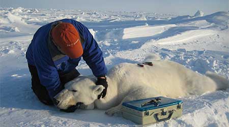
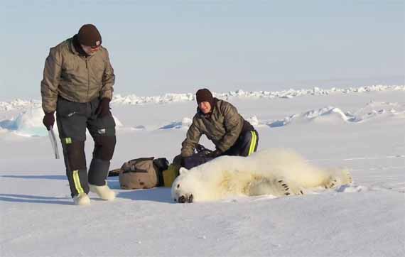
Andrew Derocher notes (via twitter) that rather than heading to shore, most of the Hudson Bay bears with satellite tracking collars (7/10) are out on the ice (Fig. 1 below). They appear to be hunting along the ice edge, where they are most likely to find seals.

Update 17 June 2015: Sea ice images for the week 18 June 2015 compared to other years added below, for Hudson Bay and the Beaufort Sea.

Continue reading

Tracking polar bears in the Southern Beaufort, with a sea ice surprise – April 2015 map

USGS biologists were clearly busy this spring putting more satellite radio collars and glue-on tags on Southern Beaufort Sea polar bears but there’s some surprising information in their April 2015 tracking map about current sea ice conditions.

From the 2013-2014 issue of  “Polar Bear News” (USFWS).

From the 2013-2014 issue of “Polar Bear News” (USFWS).

What’s interesting is that the sea ice maps they use show less dark spots that might be open water this year than were present last year in late April. Oddly, this phenomenon has one prominent biologist worried about “challenging” polar bear habitat developing this year – without mentioning last year at all.

The USGS track map for April 2015 is copied below.1
Continue reading

Tracking polar bears in the Beaufort Sea – March 2015 map

Here is the March 2015 follow-up to my post on the July 2013 track map for female polar bears being followed by satellite in the Beaufort Sea by the US Geological Survey (USGS) – “Ten out of ten polar bears being tracked this summer in the Beaufort Sea are on the ice.”

putting_collar_on_polar_bear_slider_USGS

See that post for methods and other background on this topic, and some track maps from 2012 (also available at the USGS website here). The USGS track map for March 2015 is copied below.

Three out of eight female bears tagged in the Southern Beaufort Sea were in the Chukchi Sea subpopulation region during March – not surprising, many bears cross this “boundary.”
Continue reading

Tracking polar bears in the Beaufort Sea – February 2015 map

Here is the February 2015 follow-up to my post on the July 2013 track map for female polar bears being followed by satellite in the Beaufort Sea by the US Geological Survey (USGS) – “Ten out of ten polar bears being tracked this summer in the Beaufort Sea are on the ice.”

polar_bear with collar_USGS

See that post for methods and other background on this topic, and some track maps from 2012 (also available at the USGS website here). The USGS track map for February 2015 is copied below.

There were 7 bears in February, up from 6 in January, because one of the bears has re-entered the area from elsewhere. However, many bears from the original sample have either had their collars fail, moved out of the area and stayed out, or they have died. We can’t tell from which of those options, or combinations of them, explain the reduced number still being followed.
Continue reading

Tracking polar bears in the Beaufort Sea – January 2015 map

Here is the January 2015 follow-up to my post on the July 2013 track map for female polar bears being followed by satellite in the Beaufort Sea by the US Geological Survey (USGS) – “Ten out of ten polar bears being tracked this summer in the Beaufort Sea are on the ice.”

Tranquilized_pb570_S Beaufort March 2014_USGS

See that post for methods and other background on this topic, and some track maps from 2012 (also available at the USGS website here). The USGS track map for January is copied below.

There are only 6 bears being followed now, which means a few more collars have failed, or the bears have moved out of the area or died.
Continue reading

Tracking polar bears in the Beaufort Sea – December 2014 map

Here is the December 2014 follow-up to my post on the July 2013 track map for female polar bears being followed by satellite in the Beaufort Sea by the US Geological Survey (USGS) – “Ten out of ten polar bears being tracked this summer in the Beaufort Sea are on the ice.”

Tranquilized_pb570_S Beaufort March 2014_USGS

See that post for methods and other background on this topic, and some track maps from 2012 (also available at the USGS website here). The USGS track map for December is copied below.

There are only 10 bears being followed now, which means a few more collars have failed, or the bears have moved out of the area or died.
Continue reading

Tracking polar bears in the Beaufort Sea – November 2014 map

Here is the November 2014 follow-up to my post on the July 2013 track map for female polar bears being followed by satellite in the Beaufort Sea by the US Geological Survey (USGS) – “Ten out of ten polar bears being tracked this summer in the Beaufort Sea are on the ice.”

See that post for methods and other background on this topic, and some track maps from 2012 (also available at the USGS website here). The USGS track map for November 2014 is copied below.

 Figure 1. Original caption: "Movements of 12 satellite-tagged polar bears for the month of November, 2014. Polar bears were tagged in 2014 on the spring-time sea ice of the southern Beaufort Sea. All twelve of these bears have satellite collar transmitters. Polar bear satellite telemetry data are shown with AMSR2 remotely-sensed ice coverage for 30 November, 2014." Click to enlarge, original here.


Original caption: “Movements of 12 satellite-tagged polar bears for the month of November, 2014. Polar bears were tagged in 2014 on the spring-time sea ice of the southern Beaufort Sea. All twelve of these bears have satellite collar transmitters. Polar bear satellite telemetry data are shown with AMSR2 remotely-sensed ice coverage for 30 November, 2014.” Click to enlarge, original here.

All twelve bears (all females) are finally visible on this map, confirming my suspicion that two were so close together they overlapped. Three out of the twelve “Southern Beaufort” bears were in the Chukchi Sea at the end of November (west of Point Lay, see discussion here). If you missed it, my October 2014 post on the progress of these bears has some maps from previous years that are worth reviewing.

Tracking polar bears in the Beaufort Sea – October 2014 map shows most ice since 2010

Here is the October 2014 follow-up to my post on the July 2013 track map for female polar bears being followed by satellite in the Beaufort Sea by the US Geological Survey (USGS) – “Ten out of ten polar bears being tracked this summer in the Beaufort Sea are on the ice.”

See that post for methods and other background on this topic, and some track maps from 2012 (also available at the USGS website here). The USGS track map for October 2014 is copied below (Fig. 1).

For the end of October, there was more ice in the Southern Beaufort this year than there has been since 2010.

Eight bears (all females) were on the ice and four were onshore. Only six of the eight on-ice bears were actually in the Southern Beaufort – the other two were in the Chukchi Sea (west of Point Lay, see discussion here).

Note that the recent boundary change between the Southern and Northern Beaufort subpopulations (the US/Canada boundary of the Southern Beaufort), reported here, has not addressed the fact that many western “Southern Beaufort” bears move into the Chukchi Sea. Continue reading

Tracking polar bears in the Beaufort Sea – September 2014 map

Here is the September 2014 follow-up to my post on the July 2013 track map for female polar bears being followed by satellite in the Beaufort Sea by the US Geological Survey (USGS) – “Ten out of ten polar bears being tracked this summer in the Beaufort Sea are on the ice.”

See that post for methods and other background on this topic, and some track maps from 2012 (also available at the USGS website here).

The USGS track map for September 2014 is copied below (Fig. 1).

At the end of September, with sea ice starting to rebuild, it appears there were 8 bears on the ice and three on land.

The situation for September was not very much different from August, except that two of the 11 bears (up from one) were on the ice in the Chukchi Sea in September, a phenomenon that was recently acknowledged to have affected the last population estimate for the Southern Beaufort subpopulation.

Continue reading

Tracking polar bears in the Beaufort Sea – August 2014 map

Here is the August 2014 follow-up to my post on the July 2013 track map for female polar bears being followed by satellite in the Beaufort Sea by the US Geological Survey (USGS) – “Ten out of ten polar bears being tracked this summer in the Beaufort Sea are on the ice.”

See that post for methods and other background on this topic, and some track maps from 2012 (also available at the USGS website here).

The USGS track map for August 2014 is copied below (Fig. 1).

Compare this to July’s map (Fig. 4). The 20 bears from May (down to 13 in June) are now down to 11. All seven of the bears outfitted with glue-on satellite transmitters in April [either males or subadult animals] have either moved out of the area or their tags have fallen off or stopped transmitting. This means that all of the bears shown on the maps below are females.

At the end of August, nearing the minimum extent of ice for this year, seven bears were on the ice and only four were on land.
Continue reading