Tag Archives: subpopulation boundaries

Tracking polar bears in the Beaufort Sea resumes after a one year hiatus

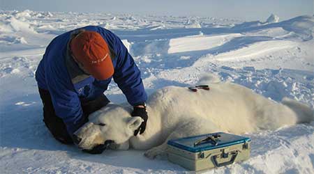
Fourteen bears tagged by the US Geological Survey (USGS) on or near the central Southern Beaufort Sea coast in April 2018 (near Kaktovik) will be tracked online over the coming months.

The break in published USGS tagging data from March 2017 to April 2018 was the first since the project began in December 2009 but no explanation for the hiatus has been provided. It is therefore unclear whether no tagging occurred in spring 2017 or data was simply not published online. The last bears followed were tagged in March 2016.

Tranquilized_pb570_S Beaufort March 2014_USGS

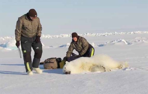
In contrast to previous years, this spring all fourteen of the bears have glue-on ear transmitters, which means they are either adult males or juvenile bears rather than females (which are fitted with satellite collars):

“In collaboration with the U.S. Fish and Wildlife Service we are also experimenting with glue-on and ear tag satellite transmitters, which can be deployed on adult male bears and younger, still-growing bears.”

Continue reading

Tracking west Alaskan polar bears in the Beaufort in October – all at Banks Is., CAN

polar-bear-habitat_usgs-from-cbc-story-sept-19-2015

Two out of three polar bear females that were collared by USGS researchers near Barrow, Alaska last spring are hanging out on the northwest coast of Banks Island, Canada. The other bear (bright green icon) appears to have been collared on the ice off Prudoe Bay in April. And as I discussed last month, it’s unusual for bears from the western end of the Southern Beaufort subpopulation (or even the central region) to end up in the Northern Beaufort subpopulation territory.

beaufort-tracking-usgs-bear-movements-october-2016-sm

Original caption: “Movements of 3 satellite-tagged polar bears for the month of October, 2016. Polar bears were tagged in 2016 on the spring-time sea ice of the southern Beaufort Sea. All 3 of these bears have satellite collar transmitters. Polar bear satellite telemetry data are shown with AMSR2 remotely-sensed ice coverage from 29 October, 2016.” See full resolution image here and close-up below.

Continue reading

Tracking polar bears in the Beaufort Sea – March 2015 map

Here is the March 2015 follow-up to my post on the July 2013 track map for female polar bears being followed by satellite in the Beaufort Sea by the US Geological Survey (USGS) – “Ten out of ten polar bears being tracked this summer in the Beaufort Sea are on the ice.”

putting_collar_on_polar_bear_slider_USGS

See that post for methods and other background on this topic, and some track maps from 2012 (also available at the USGS website here). The USGS track map for March 2015 is copied below.

Three out of eight female bears tagged in the Southern Beaufort Sea were in the Chukchi Sea subpopulation region during March – not surprising, many bears cross this “boundary.”
Continue reading

Tracking polar bears in the Beaufort Sea – October 2014 map shows most ice since 2010

Here is the October 2014 follow-up to my post on the July 2013 track map for female polar bears being followed by satellite in the Beaufort Sea by the US Geological Survey (USGS) – “Ten out of ten polar bears being tracked this summer in the Beaufort Sea are on the ice.”

See that post for methods and other background on this topic, and some track maps from 2012 (also available at the USGS website here). The USGS track map for October 2014 is copied below (Fig. 1).

For the end of October, there was more ice in the Southern Beaufort this year than there has been since 2010.

Eight bears (all females) were on the ice and four were onshore. Only six of the eight on-ice bears were actually in the Southern Beaufort – the other two were in the Chukchi Sea (west of Point Lay, see discussion here).

Note that the recent boundary change between the Southern and Northern Beaufort subpopulations (the US/Canada boundary of the Southern Beaufort), reported here, has not addressed the fact that many western “Southern Beaufort” bears move into the Chukchi Sea. Continue reading

Tracking polar bears in the Beaufort Sea – July 2014 map and subpopulation boundary issues

Here is the July 2014 follow-up to my post on the July 2013 track map for female polar bears being followed by satellite in the Beaufort Sea by the US Geological Survey (USGS) – “Ten out of ten polar bears being tracked this summer in the Beaufort Sea are on the ice.”

See that post for methods and other background on this topic, and some track maps from 2012 (also available at the USGS website here).

The USGS track map July 2004 is copied below (Fig. 1).

Compare this to June’s map (Fig. 4). The 20 bears from May (down to 14 in June) are now down to 13. All seven of the bears outfitted with glue-on satellite transmitters in April [either males or subadult animals] have either moved out of the area or their tags have fallen off or stopped transmitting. This means that all of the bears shown on the June and July maps below are females.

One bear has moved into Canadian territory and another is well into the Chukchi Sea. This is now known to be a typical rather than unusual phenomenon, and is pertinent to the bigger picture of what constitutes a discrete geographic subpopulation for polar bears.
Continue reading

New polar bear population status documents completed but have been withheld

I suggested in my last post of 2013 that the biologists of the IUCN Polar Bear Specialist Group (PBSG) might have learned some lessons over the last year about the folly of withholding evidence, fudging data, and trying to hide good news. However, it appears that was wishful thinking.

In the course of writing the essay on my top posts of 2013, I went to the PBSG website to check something, and blow me over with a feather, found an announcement that had been added a few weeks ago (December 16, 2013) without a whisper to the media.

The old PBSG page, “Population status” – which used to say “The total number of polar bears worldwide is estimated to be 20,000 – 25,000” – has been replace by a notice entitled “Population status reviews.

The former estimate population estimate (“20,000 – 25,000”) can no longer be found on the website and no other figure is offered.

The sidebar menu option “Status table” says “will be published soon.”

I’ve copied the short PBSG notice in its entirety below (pdf here):
Continue reading