
A map posted by USGS shows that the 13 polar bears with tags or collars tracked during April 2016 in the Beaufort Sea were down to 9 in May (7 females with collars, 2 subadult or adult males with tags). As two rather large patches of open water formed last month in the Beaufort – mostly due to winds and currents, rather than melt (see animation below, original post here) – a reasonable question is this: how have polar bears dealt with this somewhat unusual condition?
Beaufort Sea breakup in April due to the effects of the Beaufort Gyre (NASA video):
There is also fairly extensive open water in Hudson Bay, so the same question can be asked for that region as well – but fortunately, we have data on tagged bears from both regions to give us a clue as to how the bears are faring.
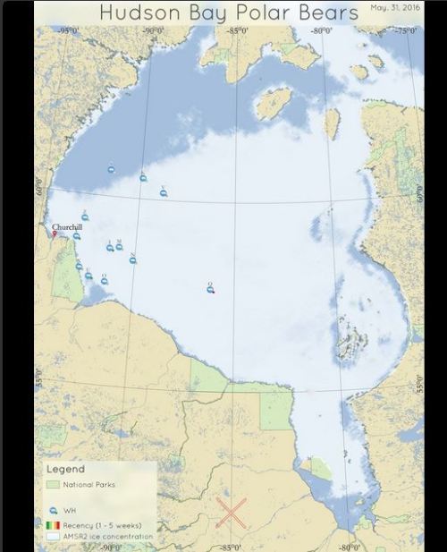
Original caption: “Movements of 9 satellite-tagged polar bears for the month of May, 2016. Polar bears were tagged in 2015 and 2016 on the spring-time sea ice of the southern Beaufort Sea. Seven of these bears have satellite collar transmitters and 2 of these bears have glue-on satellite transmitters. Polar bear satellite telemetry data are shown with AMSR2 remotely-sensed ice coverage for 31 May, 2016.” Original image here.
See the close-up of the above image below:
![]()
It’s easy to see that 7 of the 8 bears that were relatively close to shore hunting during April (one bear, with the yellow icon, was still far out on the sea ice), have simply been working the edge of the ice as it has moved north. Only 1 bear spent May on the shorefast ice close to shore, but we don’t know if it’s an adult female with a collar or a male (perhaps a subadult) with an ear tag. Subadults, of course, are much less experienced hunters and may not always make the best decisions.
But we know that such open water areas are good habitat for seals, so there is no reason to assume that most bears did not have ample opportunities to hunt in May. Just because these conditions have not been seen since 1979 is not an adequate reason to assume catastrophe is imminent.
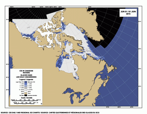
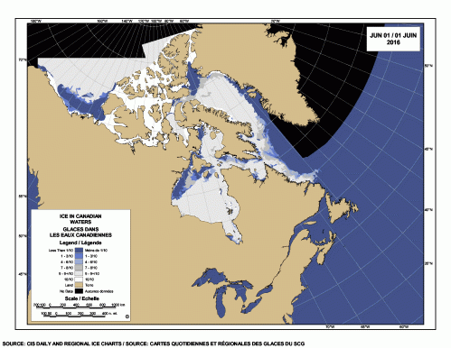
As for Hudson Bay bears, breakup in the NW quadrant is less advanced than last year at this date, as the ice maps below show.
1 June 2015:
1 June 2016:
Last year (2015), according to a map of the polar bears tracked by Andrew Derocher’s WHB research team posted online, by early May there were at least 3 bears onshore or near shore (with 2 more quite close to shore), despite there being lots of ice left on the bay:
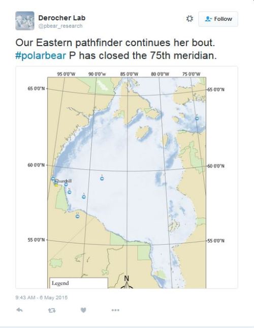
This year – with much less ice, much later in the season – a similar Derocher twitter announcement showed only one bear on or near shore at 31 May 2016 (although 3 more are quite close to shore):
The reality is that last year, despite almost constant twitter-angst (e.g., here, here and here), most collared WHB bears stayed on the ice into early July.
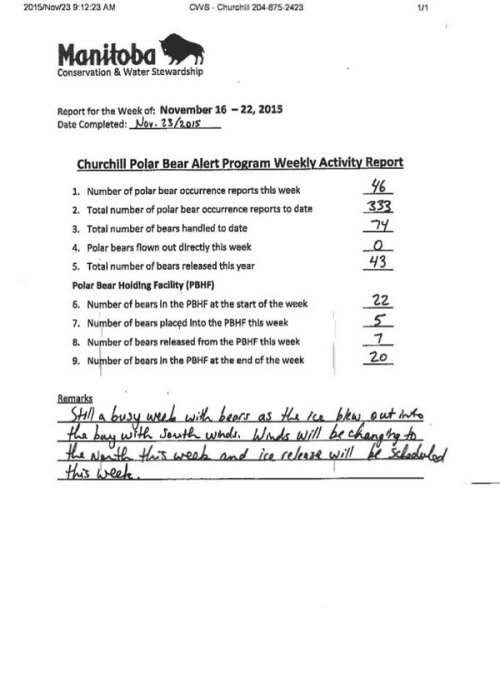
Most significantly, there were no reports last fall about swarms of starving polar bears onshore around Churchill; no pictures or videos leaked to the media of the many acts of cannibalism and attacks on humans we have been told to expect due to early ice breakup. No evidence of catastrophe whatsoever (see the last Polar Bear Alert Notice of the year, at 23 November 2015, copied below).
It seems that despite the early melt of ice in the NW portion of Hudson Bay, WHB polar bears were not in starving condition come the fall of 2015. In fact, the bears had ample time to hunt as much as they needed to, in order to survive the summer fast.
I expect the same outcome this year for both Western Hudson Bay and Southern Beaufort Sea polar bears but time will tell.


You must be logged in to post a comment.