Tag Archives: tracking

Polar bear specialist calls Hudson Bay freeze-up ‘late’ yet bears were moving offshore 2 weeks ago

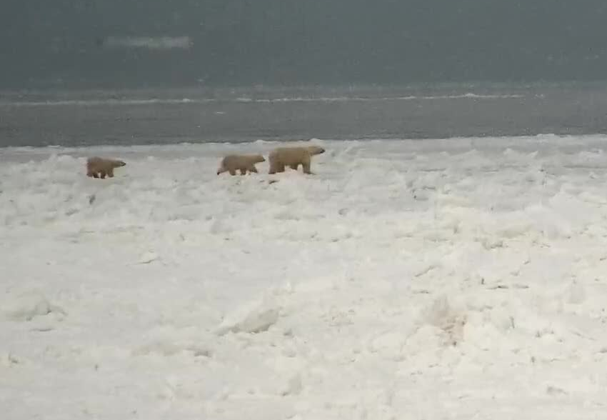
Predictably, polar bear specialist Andrew Derocher has finally posted a tracking map of the Western Hudson Bay bears his team has fitted with collars and eartags–two weeks after bears were released from Churchill’s polar bear jail, which is the local signal that there is enough sea ice for bears to leave shore. As I reported two weeks ago, release of jailed bears happened this year on 10 November. And as I predicted in that post, by waiting so long after that event to post his map, Derocher can make it seem to his naive followers on Twitter that the bears are just starting to leave now (the last map he posted was on 11 November, when none of his bears had moved). He reinforces this by calling WH freeze-up “late”, when by all objective measures (including local informants reporting bears on the ice) it was as early as it had been in the 1980s (Castro de la Guardia et al. 2017).

Recall that fall is the second-most important feeding season for polar bears, due to the fact that seals are strongly attracted to newly-forming sea ice. It’s their chance to regain some or all of the weight lost over the summer, before the long winter fast begins (while bears indeed hunt when they can, they are not often successful during the depths of the Arctic winter: most bears are at their lowest weight by March).

Continue reading

Hudson Bay sea ice freeze-up in 2022 like the 1980s for the 5th time since 2015

This is the fifth year out of the last seven that enough sea ice has formed along the west coast of Hudson Bay by mid-November for bears to be able to head out to the ice, just as it did in the 1980s.

‘Green dot’ problem bear released from Churchill holding facility on 10 November 2022. Dorota Walkoski photo.

One of the independent polar bear guides on the ground near Churchill had this to say about the bears and freeze-up conditions this year:

“Bears started leaving on November 10; conservation emptied the jail on the 10th as well.”

‘The jail’ is the Churchill Polar Bear Alert Program’s ‘holding facility’. While the Alert program folks have not released a report for this week (gee, I wonder why?), nearby tourist outfit Great White Bear Tours not only confirmed the bears were released from jail but posted a picture of a ‘green dot bear’: the mark put on problem bears released from the holding facility to keep track of them. Bears are not released before there is ample ice along shore for them to move out. Great White Bear Tours have been tracking bears moving offshore.

This information suggests the average date for bears leaving shore will likely turn out to be 12-14 November, again earlier than the average for the 1980s (16 Nov +/- 5 days) (Castro de la Guardia et al. 2017). That makes five out of the last seven years (2017, 2018, 2019, 2020, 2022) since 2015 that bears have left about the same time as they did in the 1980s.

While there are still be a few bears on the shore of Wapusk National Park that seem to be in no hurry to leave, a few stragglers doesn’t mean there isn’t ice available for hunting.

Continue reading

Polar bear habitat update for end July 2021 compared to previous years

Here’s a trip down memory lane for Arctic sea ice at the end of July, which as far as I can see provides no evidence that a very low sea ice disaster is in the cards for polar bears this year.

Continue reading

Tracking polar bears in the Beaufort Sea May and June updates

At the end of June, there were nine bears remaining from the original 14 that were tagged with glue-on ear transmittors in April 2018 near Kaktovik, Alaska by US Geological Survey biologists.

putting_collar_on_polar_bear_slider_USGS

Below is the June 2018 tracking map (high resolution image is here):

Beaufort tracking USGS bear-movements-June 2018 sm

Original caption: “Movements of 9 satellite-tagged polar bears for the month of June, 2018. These bears received satellite eartag transmitters in 2018 on the spring-time sea ice of the southern Beaufort Sea. Polar bear satellite telemetry data are shown with AMSR2 remotely-sensed ice coverage for 30 June, 2018.”

See the close-up for June 2018 below:

Beaufort tracking USGS bear-movements-June 2018 closeup

As ear tags are notoriously short-lived, there may not be any remaining by the end of July but if there are, I will post the tracks. The map for May 2018 is below.
Continue reading

Tracking polar bears in the Beaufort Sea resumes after a one year hiatus

Fourteen bears tagged by the US Geological Survey (USGS) on or near the central Southern Beaufort Sea coast in April 2018 (near Kaktovik) will be tracked online over the coming months.

The break in published USGS tagging data from March 2017 to April 2018 was the first since the project began in December 2009 but no explanation for the hiatus has been provided. It is therefore unclear whether no tagging occurred in spring 2017 or data was simply not published online. The last bears followed were tagged in March 2016.

Tranquilized_pb570_S Beaufort March 2014_USGS

In contrast to previous years, this spring all fourteen of the bears have glue-on ear transmitters, which means they are either adult males or juvenile bears rather than females (which are fitted with satellite collars):

“In collaboration with the U.S. Fish and Wildlife Service we are also experimenting with glue-on and ear tag satellite transmitters, which can be deployed on adult male bears and younger, still-growing bears.”

Continue reading

Tracking west Alaskan polar bears in the Beaufort in October – all at Banks Is., CAN

polar-bear-habitat_usgs-from-cbc-story-sept-19-2015

Two out of three polar bear females that were collared by USGS researchers near Barrow, Alaska last spring are hanging out on the northwest coast of Banks Island, Canada. The other bear (bright green icon) appears to have been collared on the ice off Prudoe Bay in April. And as I discussed last month, it’s unusual for bears from the western end of the Southern Beaufort subpopulation (or even the central region) to end up in the Northern Beaufort subpopulation territory.

beaufort-tracking-usgs-bear-movements-october-2016-sm

Original caption: “Movements of 3 satellite-tagged polar bears for the month of October, 2016. Polar bears were tagged in 2016 on the spring-time sea ice of the southern Beaufort Sea. All 3 of these bears have satellite collar transmitters. Polar bear satellite telemetry data are shown with AMSR2 remotely-sensed ice coverage from 29 October, 2016.” See full resolution image here and close-up below.

Continue reading

Tracking polar bears in the Beaufort Sea during August 2016

Only three females with collars are still being tracked by USGS researchers in the Beaufort Sea and all of them spent August 2016 on the sea ice in the eastern portion, off the coast of Banks Island.

tranquilized_pb570_s-beaufort-march-2014_usgs

Meanwhile, as Arctic sea ice nears the annual low, NSIDC predicts that 2016 will likely not set a new record but may bottom-out below 2007 (the second-lowest since 1979). The impact of low September sea ice on polar bear health and survival, based on recent research reports, will be the topic of an upcoming post.
Continue reading

Tracking polar bears in the Beaufort Sea and the issue of open water in May

A map posted by USGS shows that the 13 polar bears with tags or collars tracked during April 2016 in the Beaufort Sea were down to 9 in May (7 females with collars, 2 subadult or adult males with tags). As two rather large patches of open water formed last month in the Beaufort – mostly due to winds and currents, rather than melt (see animation below, original post here) – a reasonable question is this: how have polar bears dealt with this somewhat unusual condition?

Polar_Bear_Biologist_USFWS_working_with_a_Bear_Oct 24 2001 Amstrup photo

Beaufort Sea breakup in April due to the effects of the Beaufort Gyre (NASA video):

There is also fairly extensive open water in Hudson Bay, so the same question can be asked for that region as well – but fortunately, we have data on tagged bears from both regions to give us a clue as to how the bears are faring.
Continue reading

Tracking polar bears in the Beaufort Sea in April 2016 and early polynya formation

putting_collar_on_polar_bear_slider_USGS

Here’s the update on the polar bears fitted with satellite collars or ear tags in the Beaufort by USGS biologists over the last two years. Five new bears were added last month, which means there are now thirteen bears being tracked. Ice conditions are somewhat different than they have been in the past but concluding that such a situation means trouble is premature, I think (see here). Continue reading

Tracking polar bears in the Beaufort Sea – one tagged bear left at year end 2015

I’ve combined the months of November and December for this post on USGS polar bear tracking in the Beaufort Sea because there’s not much to tell: there’s one tagged bear left and she’s going almost nowhere. Where’s the news in that?

Beaufort tracking USGS bear-movements-November 2015 sm

Movements of 1 satellite-tagged polar bear female for the month of November, 2015; shown with sea ice coverage at 30 November 2015. This bear was tagged in the spring of 2015 in the Southern Beaufort Sea. See original image here and December movements below.

Actually, it does tell us something: this female is probably in a sea ice den, a relative common phenomenon in the Beaufort Sea. And she’s on ice that’s out over very deep water. Continue reading