
There is slightly less ice this year in Hudson Bay than last year but it is hugging tight against the western shore, which means polar bears in Western and Southern Hudson Bay will be able to stay out on the ice (if they want to) until August.
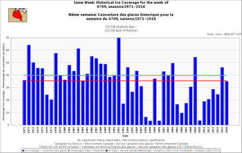
The latest weekly ice graph from the Canadian Ice Service (for 9 July) below shows average ice coverage this year (and more than there was in 1976 and 1977):
[By the way, the IUCN Polar Bear Specialist Group website is still “under construction” allowing them to avoid mentioning the less-than-dire conclusions contained in the 2015 IUCN Red List assessment]
More ice maps below, comparing previous years.
And But as a new paper by one of Andrew Derocher’s students published a few days ago shows (discussed here – along with a discussion of tight satellite collars), some polar bears actually make full use of sea ice even if the concentration is very low – even when it is undetected by satellite images. In fact, a recent tweet of Derocher’s demonstrates that point beautifully – at least 4 bears he and his colleagues are tracking appear to be in open water (see below).
Derocher uses ice data for his WHB polar bear tracking maps that show only the most concentrated ice, even though he is well aware that some bears use any scrap of ice they can find at this time of year – since he recently co-authored two papers on that very topic (Cherry, Derocher and Lunn 2016; Pongracz and Derocher 2016). The Canadian Ice Service (CIS) and NSIDC Masie charts use data from several sources to generate daily maps that show a more accurate picture (but they still probably miss some of it).
As was true at the end of June, according to NSIDC Masie ice charts, the amount and pattern of ice on 12 July 2016 was slightly less than it was in 2009 but the coverage was very similar – 2009 was the year when polar bears left the ice as late as they did in 1992 (the latest breakup year since 1979, discussed most recently here).
12 July 2016, to compare to previous years:

12 July 2009, latest breakup year since 1979:

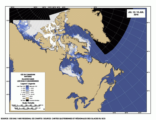
CIS map for 14 July 2016 below:

Last year (2015, below), more of the remnant sea ice was in central and eastern Hudson Bay rather than along the west coast (where polar bears depart the ice to spend the summer) but still, there were no reports of starving bears in Churchill:

In 2014, little remnant ice remained at this date but it was well positioned for polar bears to get ashore:

In 2013, there was less ice remaining at this date than this year (and it was less concentrated) but it was positioned similarly, making it easy for Western Hudson Bay and Southern Hudson Bay bears to reach the shore:

References
Cherry, S.G., Derocher, A.E., and Lunn, N.J. 2016. Habitat-mediated timing of migration in polar bears: an individual perspective. Ecology and Evolution. DOI 10.1002/ece3.2233 Open access. http://onlinelibrary.wiley.com/doi/10.1002/ece3.2233/full
Pongracz, J.D. and Derocher, A.E. 2016. Summer refugia of polar bears (Ursus maritimus) in the southern Beaufort Sea. Polar Biology. 08 July 2016
DOI 10.1007/s00300-016-1997-8 http://link.springer.com/article/10.1007/s00300-016-1997-8


You must be logged in to post a comment.