
Satellites images might be able to replace aerial counts of polar bears in some places — if there are no clouds. But it seldom distinguishes cubs and can’t tell males from females, found a 2012 study of Foxe Basin bears that’s just been published.
Note: This is my 200th post since July 26, 2012!
From a story in Alaska Dispatch (“Researchers turn to satellite monitoring to count polar bear populations” Y. Rosen, July 9, 2014):
“In a project conducted in part of the Canadian territory of Nunavut and described in a research paper published in Wednesday’s issue of the journal PLOS One, U.S. and Canadian scientists applied satellite imagery technology to an area that was also being surveyed by helicopter, and they compared the findings. The result? Both techniques produced similar estimates for the number of polar bears in the study area.
“The remarkable consistency between our estimates of abundance derived from imagery and established aerial survey techniques suggests that bear identification using imagery was quite accurate,” the study said.
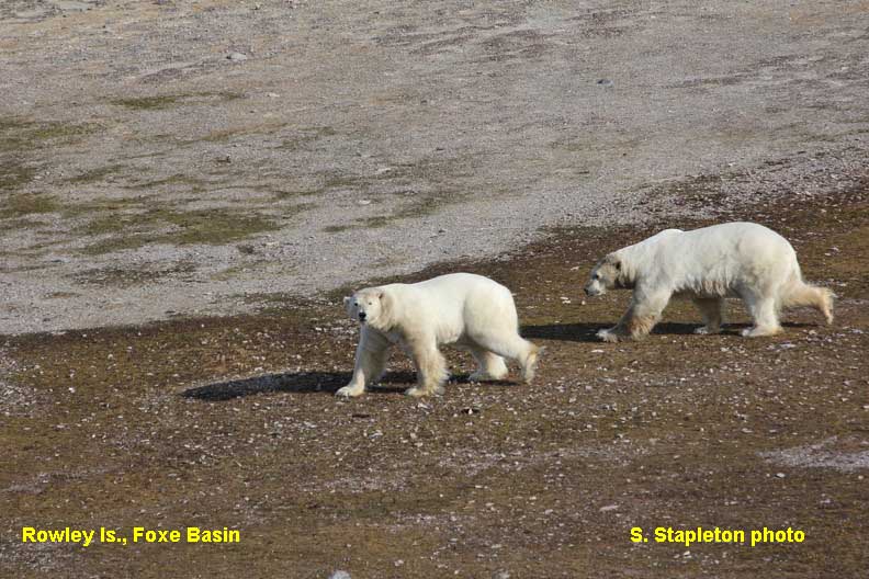
The study took place at Rowley Island in Nunavut’s Foxe Basin in summer, when the area is ice-free and when bears are most visible in that area. The counts were conducted in September 2012, which also happened to be the month when Arctic sea ice hit its record low coverage.
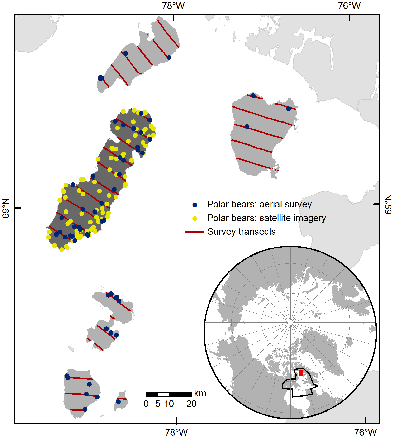
Figure 1. This is where the study was conducted, in Foxe Basin (north of Hudson Bay) in the summer of 2012. Rowley Island is the large one, with the yellow dots. This is Fig. 1 from Stapleton et al. 2014.
“We selected Rowley as our study site because bear density is high during summer and the flat terrain provides an ideal setting to evaluate the use of satellite imagery,” study leader Seth Stapleton, a former USGS scientist who is now at the University of Minnesota, said in a statement issued by the agency.
Satellite imagery detected what was estimated to be 94 bears, while the aerial counts made by helicopter found 77 individuals, yielding a population estimate of 102 for the island when a model was applied, the study said.
The satellite images were not recorded at precisely the same time the helicopter survey was conducted, said Todd Atwood, research leader for the USGS Polar Bear Research Program. It is possible that some bears moved on or off the island during the lag between the counts, he said. But since the island was surrounded by open water, it is believed that most of the bears on the island would stay in place at that time of the year, he said.
There was “significant overlap” in the confidence intervals around the satellite-imagery counts and the helicopter-survey counts, leading scientists to believe the methods were equally effective in counting bears, Atwood said.
One limitation of satellite imagery was the inability to count cubs, presumed to be too small to be detected by the available resolution, according to the study.” [my bold]
See also the story at Nunatsiaq Online (from February 27, 2014) http://www.nunatsiaqonline.ca/stories/article/65674counting_polar_bears_from_space/
From the paper itself:
“Observers differed substantially in their abilities to detect bears with imagery. This finding was an unexpected but important result of this study; this did not diminish the robustness of our results, although precision would improve with higher detection for both observers. In our study, the two observers had vastly different levels of experience: one had several seasons of experience studying polar bears in this landscape during the ice-free season, whereas the other had extensive experience interpreting remote sensing imagery but no direct experience with polar bears. The observer with field experience had better detection of bears on the images, suggesting that familiarity with the study landscape and first-hand knowledge of bear biology and behavior (e.g., variation in color and body outline based on posture) greatly improved detection. Moreover, the observers searched imagery somewhat differently. We found that detection was higher when one regularly compared the target and reference images (one’s eye was attracted to white spots on the target image not present on the reference image), rather than using the reference image to simply verify the presence of bears. These experiences suggest that explicit search protocols and a rigorous training program including individuals with relevant, on-the-ground experience with the target species will improve implementation of the technique and ensure appropriate search images.
The two abundance estimation techniques provided significantly different estimates of precision (coefficients of variation for line transect aerial survey: 20.4% versus satellite imagery: 2.5%). Distance sampling incorporates multiple variance components, including detection and encounter rates on sampled transects. Conversely, the satellite imagery modeling only includes a variance component for detection, since we reviewed imagery from the entire island. The very high detection probability of one imagery observer also contributed to this difference. Variance estimated from manual review of imagery would increase in applications in which observers have lower detection probabilities or if images provide less complete coverage of the study site.”
…
We presumed that cubs were not consistently identifiable on imagery, given the resolution constraints. Their presence was suggested by multiple white spots of notably different sizes in a cluster (ca.<20 m). We detected only five likely family groups with imagery, whereas the nine family groups sighted on Rowley Island during aerial survey sampling suggest that there were ~28 family groups present island-wide. The inability to reliably discern family groups poses some limits on the utility of imagery for demographic studies. However, the advent of higher resolution imagery (e.g., WorldView-3 platform, set to launch in 2014, will shoot at 0.3 m resolution at nadir) may permit differentiation of cubs, as well as improve detection of smaller species, in the future.” [my bold]
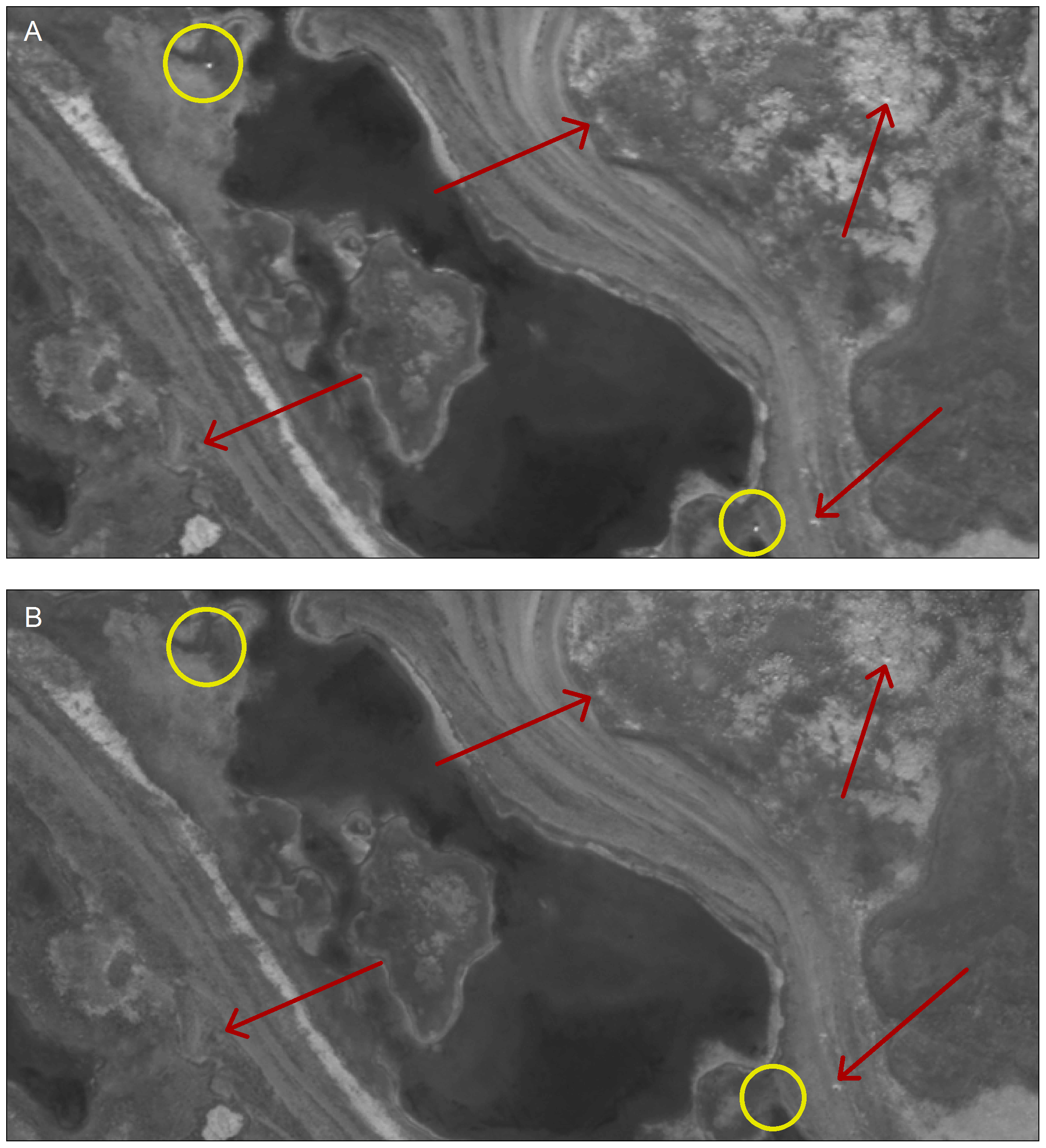
Figure 2. This is what adult polar bears on an island, in summer, look like from space (upper image (a), in yellow circles). Red arrows point to rocks and other features in the landscape. Cubs are generally too small to see. This is Fig. 2 from Stapleton et al. 2014: the lower image (b) is a reference shot without bears, so the presence of white dots in the “target” image (a) are inferred to be polar bears (yellow circles).
The paper is called “Polar Bears from Space: Assessing Satellite Imagery as a Tool to Track Arctic Wildlife” and the citation (and link) for it are below.
Stapleton S, LaRue M, Lecomte N, Atkinson S, Garshelis D, Porter, C. and Atwood, T. 2014. Polar bears from space: assessing satellite imagery as a tool to track Arctic wildlife. PLoS ONE 9(7): e101513. doi:10.1371/journal.pone.0101513 Open access http://www.plosone.org/article/info%3Adoi%2F10.1371%2Fjournal.pone.0101513
Abstract
Development of efficient techniques for monitoring wildlife is a priority in the Arctic, where the impacts of climate change are acute and remoteness and logistical constraints hinder access. We evaluated high resolution satellite imagery as a tool to track the distribution and abundance of polar bears. We examined satellite images of a small island in Foxe Basin, Canada, occupied by a high density of bears during the summer ice-free season. Bears were distinguished from other light-colored spots by comparing images collected on different dates. A sample of ground-truthed points demonstrated that we accurately classified bears. Independent observers reviewed images and a population estimate was obtained using mark–recapture models. This estimate ( : 94; 95% Confidence Interval: 92–105) was remarkably similar to an abundance estimate derived from a line transect aerial survey conducted a few days earlier ( : 102; 95% CI: 69–152). Our findings suggest that satellite imagery is a promising tool for monitoring polar bears on land, with implications for use with other Arctic wildlife. Large scale applications may require development of automated detection processes to expedite review and analysis. Future research should assess the utility of multi-spectral imagery and examine sites with different environmental characteristics.


You must be logged in to post a comment.