
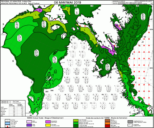
The chart below shows what sea ice thickness over Hudson Bay was like at the first week of May in a so-called a ‘good year’ (2019) – when polar bears came off the ice in excellent condition late in the summer and left early in the fall (‘thick first year ice’ is dark green and indicates ice greater than 1.2m thick):
Hudson Bay ice conditions this year appear to be shaping up to be as good or better than last year for polar bears yet specialist researchers and their cheerleaders have still been claiming that bears in this region – Western and Southern Hudson Bay – are doomed because of poor ice conditions. It’s no wonder they still haven’t published the data they’ve been collecting on polar bear body condition and cub survival over the last 15 years or so (Crockford 2020). With most field work cancelled for this year, what’s their excuse for not getting that done?
Compare the above, from the Canadian Ice Service, to the first week in May 2020 below, where the thick ice is much more prominent than last year in the northwest quadrant. A massive polar vortex over eastern North America forecasted for this weekend is likely to thicken up the ice in the south (over James Bay) in short order:

Courtesy Dr. Andrew Derocher (U. Alberta), below is a map of locations of female bears with collars deployed by his research team at the end of April 2020:
![]()
References
Crockford, S.J. 2020. State of the Polar Bear Report 2019. Global Warming Policy Foundation Report 39, London. PDF here.


You must be logged in to post a comment.