Tag Archives: Mt. Pinatubo

2nd highest ice coverage for Hudson Bay since 1971 at mid-August – only 1992 higher

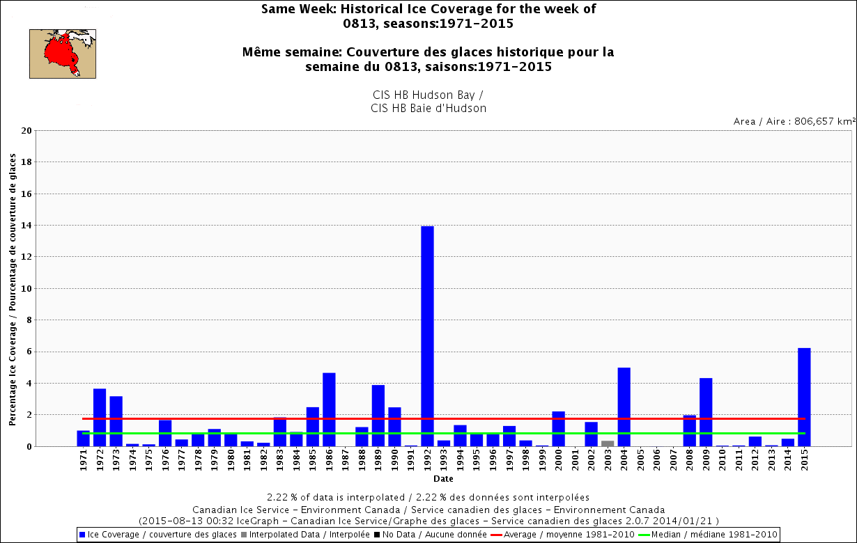
Since 1971, there has been no year when there was as much ice left on Hudson Bay as there is this year at August 13th, except 1992 – the year when Mt. Pinatubo seemingly affected Hudson Bay ice levels but not any other region in Eastern Canada or the Beaufort Sea. Odd, that – see the graphs below.

Hudson Bay same week 13 Aug 1971-2015

Doesn’t mean that much to polar bears, since they will mostly be fasting whether they are onshore for the summer or riding the ice – they primarily live off their fat this time of year. Still, the relative ice levels are interesting because it could impact freeze-up dates later this fall, which will influence the bears’ ability to hunt before the winter fast sets in.

Continue reading

Polar bear habitat update: highly concentrated ice in eastern Hudson Bay this spring

Sea ice in eastern Hudson Bay (bright white in the map below) is more concentrated than at this time last year and similar to the ice found in the Central Canadian Arctic.

Sea ice extent Canada 2015 April 11 CIS

There is more concentrated ice (10/10 concentration) in the east side of the Bay than there was in 1992, a heavy ice year blamed in part on the eruption of Mt. Pinatubo (Chambellant et al. 2012) that resulted in the latest breakup date for Western Hudson Bay since 1991.

Continue reading

Foxe Basin and Hudson Bay have more than average polar bear hunting habitat

This is shaping up to be a banner year for polar bears in Foxe Basin (central Canada), with more ice in this region than there’s been since 1992. Hudson Bay still has a large patch of thick first year ice, more than there has been at this date since 2009, which was a late breakup year.

Hudson Bay Foxe Basin ice map Aug 7 2014 labeled_sm

Ice maps and charts below tell the story.
Continue reading