Tag Archives: polar bear habitat

Ice maps vs. observations in the W. Arctic – polar bear habitat reality check

Last Wednesday (8 June 2016), the US Coast Guard rescued walrus hunters from Shishmaref in the Bering Strait who got stuck in sea ice that is barely visible on sea ice maps. It’s a rare glimpse of what sea ice really looks like up close compared to what you see on the ice maps.

Watch the video here: https://www.dvidshub.net/video/embed/467959

[Unfortunately, the screencaps from the video, like the one below, are less impressive than the film. In the video, you can see the hunters walking on the ice around their trapped boat – the ice does not visibly move]

Shishmaref_ice_CoastGuard 02_8 June 2016

Have a look at the sea ice maps below for the day the incident took place. They show what appears to be hardly any ice in the area.

This is a good lesson for assessing what’s been going on in the Beaufort Sea a bit further east, where winds and currents have opened up a rather large patch of open water surrounded by considerable expanses of sea ice – at issue is the possible impact on polar bear spring feeding for April and May.
Continue reading

Genetic similarity of polar bears does not make them vulnerable to global warming

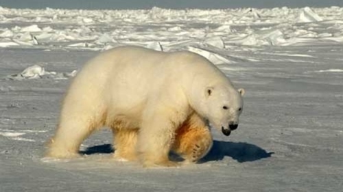
A new genetics paper suggests that global warming will “fragment” polar bear habitat to such an extent that it will further reduce the already-low genetic variability documented in the bears, with disastrous effects on survival.

Beaufort Sea male polar bear USGS_2005 Amstrup photo

However, that argument only works if you disregard a rather large body of literature on other mammals as well as the history of polar bears themselves. I’ve addressed this issue before (“Low genetic diversity will not make polar bears more vulnerable to extinction”) and what I said then needs to be repeated now:

“…there is lots of evidence to support my contention that polar bears are not more vulnerable to extinction just because they have low genetic diversity.

I continued:

Many populations that were reduced to very low numbers (i.e., gone through a ‘bottleneck’ ), ending up with low genetic variation, have subsequently recovered dramatically without adverse affects.

In other words, they not only recouped their population size after a population bottleneck but did so while dealing with subsequent environmental fluctuations and other natural threats to their survival (Lehman 1998:R723-724).

In some cases, genetic diversity increased after a population bottleneck, via mechanisms biologists are only just beginning to understand.

In fact, there is good evidence to suggest that ice age cooling is what previously fragmented polar bear populations: past warm interglacial periods brought bears closer together, confined more or less to the area within the Arctic Circle – even in winter.

Go back and read the entire genetic diversity post. I concluded it by recounting several examples of abundant and successful mammal populations with low genetic diversity (with references), including Northern elephant seals, Guadalupe fur seal, Sand Nicolas Island fox, Mouflon sheep, and North Atlantic right whale. The details are worth reviewing. If you can’t access a paper you want to read, contact me via the contact page above and I’ll send it along.

Regarding this new paper (Kutschera et al. 2016), what I said before needs repeating:

“To suggest that polar bears cannot endure a bit of Arctic warming in the future (whether natural or due to human influences on climate, or a bit of both) is absurd: climatic extremes have defined the evolutionary history of polar bears, which means that climatic extremes have fine-tuned their biological adaptability.”

In fact, the paleoclimate/genetics paper by Cronin and Cronin (2015) which I summarized a few days ago, documents those climatic extremes. See below for details on the polar bear genetic diversity paper.
Continue reading

Tracking polar bears in the Beaufort Sea – March 2015 map

Here is the March 2015 follow-up to my post on the July 2013 track map for female polar bears being followed by satellite in the Beaufort Sea by the US Geological Survey (USGS) – “Ten out of ten polar bears being tracked this summer in the Beaufort Sea are on the ice.”

putting_collar_on_polar_bear_slider_USGS

See that post for methods and other background on this topic, and some track maps from 2012 (also available at the USGS website here). The USGS track map for March 2015 is copied below.

Three out of eight female bears tagged in the Southern Beaufort Sea were in the Chukchi Sea subpopulation region during March – not surprising, many bears cross this “boundary.”
Continue reading

Tracking polar bears in the Beaufort Sea – February 2015 map

Here is the February 2015 follow-up to my post on the July 2013 track map for female polar bears being followed by satellite in the Beaufort Sea by the US Geological Survey (USGS) – “Ten out of ten polar bears being tracked this summer in the Beaufort Sea are on the ice.”

polar_bear with collar_USGS

See that post for methods and other background on this topic, and some track maps from 2012 (also available at the USGS website here). The USGS track map for February 2015 is copied below.

There were 7 bears in February, up from 6 in January, because one of the bears has re-entered the area from elsewhere. However, many bears from the original sample have either had their collars fail, moved out of the area and stayed out, or they have died. We can’t tell from which of those options, or combinations of them, explain the reduced number still being followed.
Continue reading

Tracking polar bears in the Beaufort Sea – January 2015 map

Here is the January 2015 follow-up to my post on the July 2013 track map for female polar bears being followed by satellite in the Beaufort Sea by the US Geological Survey (USGS) – “Ten out of ten polar bears being tracked this summer in the Beaufort Sea are on the ice.”

Tranquilized_pb570_S Beaufort March 2014_USGS

See that post for methods and other background on this topic, and some track maps from 2012 (also available at the USGS website here). The USGS track map for January is copied below.

There are only 6 bears being followed now, which means a few more collars have failed, or the bears have moved out of the area or died.
Continue reading

Tracking polar bears in the Beaufort Sea – December 2014 map

Here is the December 2014 follow-up to my post on the July 2013 track map for female polar bears being followed by satellite in the Beaufort Sea by the US Geological Survey (USGS) – “Ten out of ten polar bears being tracked this summer in the Beaufort Sea are on the ice.”

Tranquilized_pb570_S Beaufort March 2014_USGS

See that post for methods and other background on this topic, and some track maps from 2012 (also available at the USGS website here). The USGS track map for December is copied below.

There are only 10 bears being followed now, which means a few more collars have failed, or the bears have moved out of the area or died.
Continue reading

Polar bear habitat – more Arctic sea ice in Canada this week than in early 1970s

This week, Arctic sea ice in Canada, where 2/3 of the world’s polar bears live, had more sea ice than was present in the early 1970s. Globally, the ice is spitting-distance close to the 1981-2010 average calculated by the NSIDC for this date – which means lots of winter/spring hunting habitat for polar bears.

Canada sea ice freeze-up_same week_Dec 25 1971_2014 standard average

This is the peak of the polar bear birthing season (both in the wild and in zoos.) Newborns will be snug in maternity dens built by their mothers onshore or on the sea ice; the rest of the population will be out on the ice.

Sea ice extent 2014 Dec 25 NSIDC

Regional ice charts going back to the late 1960s and early 1970s for this week show even more surprises — have a look.

Continue reading

Hudson Bay sea ice well above average – excellent early December polar bear habitat

Sea ice development for this date is well above average on Hudson Bay – even more so than last week – making three years in a row of average-to-above average ice habitat available to polar bears in early December (see last week’s ice summary here). Coverage for the week of 11 December from 1971 to 2104 below (from Canadian Ice Service):

Hudson Bay freeze-up same week_Dec 11 1971_2014 w average

More maps below (from CIS and NSIDC), see others here.

Continue reading

Tracking polar bears in the Beaufort Sea – November 2014 map

Here is the November 2014 follow-up to my post on the July 2013 track map for female polar bears being followed by satellite in the Beaufort Sea by the US Geological Survey (USGS) – “Ten out of ten polar bears being tracked this summer in the Beaufort Sea are on the ice.”

See that post for methods and other background on this topic, and some track maps from 2012 (also available at the USGS website here). The USGS track map for November 2014 is copied below.

 Figure 1. Original caption: "Movements of 12 satellite-tagged polar bears for the month of November, 2014. Polar bears were tagged in 2014 on the spring-time sea ice of the southern Beaufort Sea. All twelve of these bears have satellite collar transmitters. Polar bear satellite telemetry data are shown with AMSR2 remotely-sensed ice coverage for 30 November, 2014." Click to enlarge, original here.


Original caption: “Movements of 12 satellite-tagged polar bears for the month of November, 2014. Polar bears were tagged in 2014 on the spring-time sea ice of the southern Beaufort Sea. All twelve of these bears have satellite collar transmitters. Polar bear satellite telemetry data are shown with AMSR2 remotely-sensed ice coverage for 30 November, 2014.” Click to enlarge, original here.

All twelve bears (all females) are finally visible on this map, confirming my suspicion that two were so close together they overlapped. Three out of the twelve “Southern Beaufort” bears were in the Chukchi Sea at the end of November (west of Point Lay, see discussion here). If you missed it, my October 2014 post on the progress of these bears has some maps from previous years that are worth reviewing.

Hudson Bay sea ice above average for this date – more good news for polar bears

It’s only the 4th of December and Hudson Bay ice formation is way up over late 2000s coverage for this date — and higher than 2012, which had the lowest overall September ice extent for the Arctic since 1978.

Hudson Bay freeze-up same week_Dec 4 1971_2014 w average

This means boom times for Western and Southern Hudson Bay polar bears as sea ice formation is several days to a week ahead of last year. And as I mentioned in my last post, average November ice coverage across the Arctic this year was higher than 2003. Don’t forget that 2/3’s of the world’s polar bears live in Canada (see recent status update here; map below).

Figure 4. The Davis Strait (DS) subpopulation region runs from just below the Arctic Circle at the north end to at least 470N in the south. About half of DS lays at the same latitude as Western Hudson Bay (WH). Courtesy Environment Canada.

Polar bear population status in Canada. Courtesy Environment Canada.

More maps and charts below.
Continue reading