Tag Archives: polar bears

Tracking polar bears in the Beaufort Sea – more bears added to the April 2014 map

Polar bears were tagged in 2013 and 2014 on the spring-time sea ice of the southern Beaufort Sea. Seventeen of these bears have satellite collar transmitters and 7 of these bears have glue-on satellite transmitters” say the folks at the USGS Alaska Science Center.

I guess that’s why the April map was late getting posted.

Polar bear ear tag_USFWS_PolarBearNews2010

Continue reading

My upcoming lecture at House of Lords, London: how to get invited

Benny Peiser of the Global Warming Policy Foundation (GWPF) has arranged for me to give a lecture at the House of Lords (London) on June 11.

Healthy Polar Bears, Less Than Healthy Science
A lecture by Dr. Susan J. Crockford

When: 11 June 2014, 6pm

Where: House of Lords, Committee Room 3, London

Crockford 08_21_2011_0056b

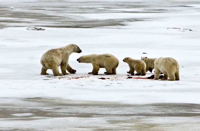
This lecture focuses on recent research results that have shown that polar bear populations are not responding as predicted to recent declines in Arctic sea ice. Despite the fatalistic attitude of many polar bear field biologists, real-world evidence indicates that polar bears are well equipped to survive substantial variations in their Arctic sea ice habitat and have not been harmed by recent low ice coverage. Such resilience over the short term is hardly surprising, since polar bears are now known to have survived a multitude of past climate shifts of almost inconceivable magnitude.

As the venue has limited space, interested readers in the UK may contact the GWPF at info@thegwpf.org for an invitation. They will let you know if places are still available.

Hope to meet some of you there.

Susan

PS. I will be staying near Bristol later that week with relatives (June 13-15) and could take an afternoon or evening for a pub chat about polar bears and other issues, if anyone is interested. Send me a note via the contact page above.

Ancestor of the polar bear by any name: grizzly vs. brown bear monikers explained

Apparently, all media outlets (except Fox News) so confused the distinction between the two common names used for the ancestor of polar bears, Ursus arctos, that they got the point of a recent news story totally wrong. An Alaskan journalist explains.

Coastal brown bears from Admiralty Island, southeast Alaska. See previous post here.

Coastal brown bears from Admiralty Island, southeast Alaska (courtesy Jim Baichtal, US Forest Service, Alaska). See previous post here.

Tundra grizzly from the Yukon (courtesy Government of Yukon Territory). These bears also occur across the north slope of Alaska and are the bears that occasionally hybridize with polar bears, as explained here.

Tundra grizzly bear from the Yukon (courtesy Government of Yukon Territory). These bears also occur across the north slope of Alaska and are the bears that occasionally hybridize with polar bears this time of year, as explained here.

Continue reading

Tracking polar bears in the Beaufort Sea – April map not yet available

Cannot do my April follow-up to my post on the July 2013 track map for female polar bears being followed by satellite in the Beaufort Sea by the US Geological Survey (USGS) – Ten out of ten polar bears being tracked this summer in the Beaufort Sea are on the ice.

“Tracking Polar Bears by Satellite” has not yet been updated with the April map, which is unusual for this late in the month (it is usually updated within the first few working days of every month). Perhaps the sea ice data they use was late being processed?

Here is the map for March, discussed previously here.

Figure 1. Movements of 5 satellite-tagged polar bears for the month of March, 2014. Polar bears were tagged in 2013 on the spring-time sea ice of the southern Beaufort Sea. All 5 of these bears have satellite collar transmitters. Note that the dots with the polar bear icons are the end points (end March), while the other end of the string is their position in early March. These are the same 5 females that were present in January. Click to enlarge.

Figure 1. Movements of 5 satellite-tagged polar bears for the month of March, 2014. Polar bears were tagged in 2013 on the spring-time sea ice of the southern Beaufort Sea. All 5 of these bears have satellite collar transmitters. Note that the dots with the polar bear icons are the end points (end March), while the other end of the string is their position in early March. These are the same 5 females that were present in January. Click to enlarge.

Previous dates for tracking available here.

Tracking polar bears in the Beaufort Sea: March map

Here is the March 2014 follow-up to my post on the July 2013 track map for female polar bears being followed by satellite in the Beaufort Sea by the US Geological Survey (USGS) – “Ten out of ten polar bears being tracked this summer in the Beaufort Sea are on the ice.”

See that post for methods and other background on this topic, and some track maps from 2012 (also available at the USGS website here).

The USGS track map March 2014 is copied below (Fig. 1).

Compare this to February’s map (Fig. 2) – you’ll be surprised at how little has changed!

Figure 1. Movements of 5 satellite-tagged polar bears for the month of March, 2014. Polar bears were tagged in 2013 on the spring-time sea ice of the southern Beaufort Sea. All 5 of these bears have satellite collar transmitters. Note that the dots with the polar bear icons are the end points (end March), while the other end of the string is their position in early March. These are the same 5 females that were present in January. Click to enlarge.

Figure 1. From original caption: “Movements of 5 satellite-tagged polar bears for the month of March, 2014. Polar bears were tagged in 2013 on the spring-time sea ice of the southern Beaufort Sea. All 5 of these bears have satellite collar transmitters.” Note that the dots with the polar bear icons are the end points (end March), while the other end of the string is their position in early March. These are the same 5 females that were present in January. Click to enlarge.

Continue reading

Of Labrador polar bears and sea ice way above normal off Newfoundland

A report yesterday of polar bears making a nuisance of themselves in Black Tickle, southern Labrador is the inspiration for this post. Those bears are part of the Davis Strait subpopulation (discussed previously here and here). Black Tickle is marked on the map below.

Black-tickle-map-Labrador

Arctic sea ice is tracking just at the edge of two standard deviations for this time of year but while extent is low in the Barents Sea, it is way up around the east coast of Canada.
Continue reading

Tracking polar bears in the Beaufort Sea: February map

Here is the February 2014 follow-up to my post on the July 2013 track map for female polar bears being followed by satellite in the Beaufort Sea by the US Geological Survey (USGS) – Ten out of ten polar bears being tracked this summer in the Beaufort Sea are on the ice.

See that post for methods and other background on this topic, and some track maps from 2012 (also available at the USGS website here).

The USGS track map February 2014 is copied below (Fig. 1).

Continue reading

Tracking polar bears in the Beaufort Sea: January map

Here is the January 2014 follow-up to my post on the July 2013 track map for female polar bears being followed by satellite in the Beaufort Sea by the US Geological Survey (USGS) – Ten out of ten polar bears being tracked this summer in the Beaufort Sea are on the ice.

See that post for methods and other background on this topic, and some track maps from 2012 (also available at the USGS website here).

The USGS track map for January 2014 is copied below (Fig. 1).

Both the Southern Beaufort and the Chukchi Sea were completely ice-covered by the end of January. The seven bears tracked during November and December were reduced to five in January — down 50% from the ten bears collared in July.
Continue reading

Polar bear female with cubs fights off adult male – photos from W Hudson Bay

Discovery News ran a photo feature yesterday (January 28, 2014), courtesy Mike Lockhart from Polar Bears International, of an interesting incident Lockhart witnessed while was working with a government (Manitoba Conservation) research team surveying bears of Western Hudson Bay in the fall of 2013.

Figure 1. Female with 2 cubs turns on an adult male (far right) that she had been happily feeding with moments before. Mike Lockhart photo, Polar Bears International and Discovery News.

Figure 1. Female with 2 cubs turns on an adult male (far left) that she had been happily feeding with moments before. This is the 3rd photo in the sequence; see description and photo 4 below. Mike Lockhart photo, Polar Bears International, Discovery News story.

Continue reading

Tracking polar bears in the Beaufort Sea: December map

Here is the December 2013 follow-up to my post on the July track map for female polar bears being followed by satellite in the Beaufort Sea by the US Geological Survey (USGS) – Ten out of ten polar bears being tracked this summer in the Beaufort Sea are on the ice.

See that post for methods and other background on this topic, and some track maps from 2012 (also available at the USGS website here).

The track map for December 2013 is copied below (Figure 1).

There has been little change from November: six of the bears that were being tracked in October were still present (down from ten in July) and one bear that went Arctic walkabout in October has returned and is still in the area. The same seven bears present in November were still being tracked in December but did not move very much. Continue reading