
I’ve written before about the incidents of starving polar bears in the eastern portion of the Southern Beaufort Sea (here, here, and here). For two or three years every decade since the 1960s, shorefast ice in the Eastern Beaufort (Fig. 1) has become too thick and compressed in the spring for ringed seals to maintain their breathing holes, so most or all of them presumably go elsewhere — as seals did in Greenland when ice got too thick there (Vibe 1965). With few or no seal pups born during March and April in thick ice years, some bears had a hard time finding enough food: starving bears and dying cubs were the result.
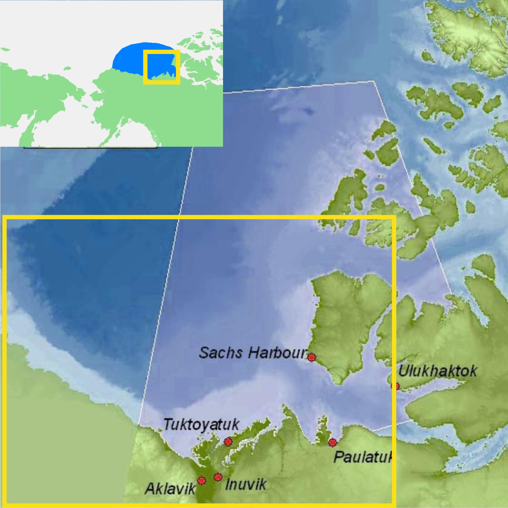
Figure 1. ‘Eastern Beaufort’ (yellow square) polar bear study region.
The communities of Tuktoyatuk (locally known as ‘Tuk’), and Sachs Harbour on southern Banks Island have been used as base camps for polar bear research because they are accessible by plane via the larger community of Inuvik.
The light blue portions along western Banks Island and the Eastern Beaufort/Yukon mainland coast indicate shallow continental shelf areas (20 km wide in places) where extensive shorefast ice develops every winter.
Main map from Beaufort Sea Partnership, inset map from Wikipedia.
I’ve been trying to get my head around why this would happen in the Eastern Beaufort. Once or twice – maybe – but several times every decade? What on earth drives such a process?
So, I did some reading (actually, quite a lot of reading) and have what appears to be at least a partial answer.
All indications are that the occasional development of exceptionally thick spring ice in the Eastern Beaufort is the result of an entirely natural, cyclical phenomenon. However, some polar bear biologists are attempting to blame the latest episode (but not earlier ones) on increased amounts of open water in the Chukchi Sea during fall of the early 2000s. That doesn’t seem a plausible explanation to me, given the history of the sea ice in this region. Have a look.
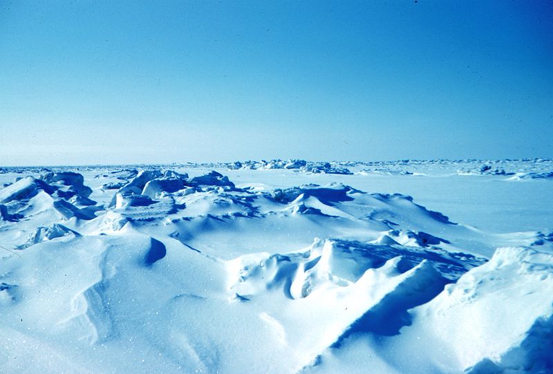
Figure 2. Beaufort sea pressure ridges, spring 1949. Courtesy Wikipedia (from NOAA’s “At the ends of the Earth” image collection #corp1014).
Andrew Mahoney from University of Alaska Fairbanks (Mahoney 2012) describes the Beaufort ice situation very nicely:
“Circulation in the Beaufort Sea is dominated by the clockwise motion of the Beaufort Gyre, which transports into the Beaufort Sea some of the oldest and thickest ice in the Arctic from the region north of the Canadian Archipelago.”[my bold]
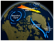
Figure 3. The Beaufort Gyre.
See it in action in Figs.4 and 5.
See also the National Snow and Ice Data Center (NSIDC) description.
As Fig. 4 below shows, this seems to be exactly what happened in April this year (2013) – the wind-driven currents of the Beaufort Gyre grabbed hold of the edge of the thick band of multiyear ice that persists north of the Central Canadian Arctic and spun some of it south into the Eastern Beaufort.
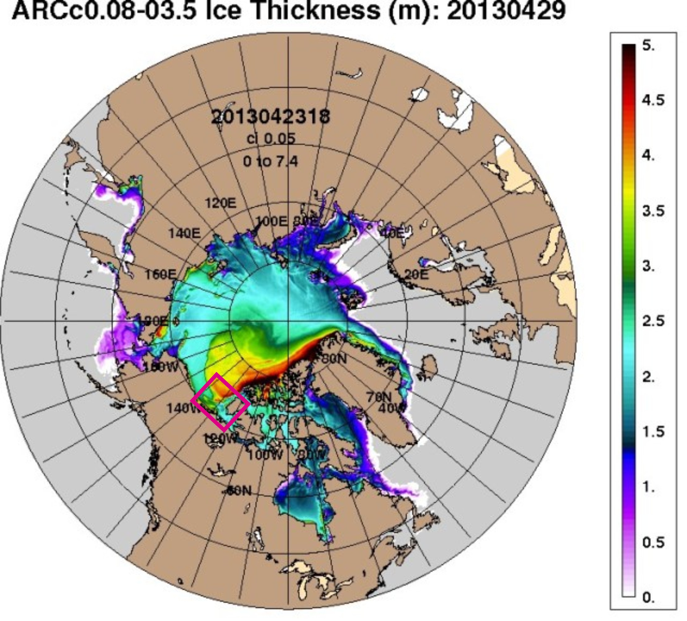
Figure 4. Ice thickness in the Arctic, as of April 27, 2013 (produced by the US Navy). Notice that some of the thickest ice (yellow and red, 3.5-4.5m thick) is curling towards the Eastern Beaufort/Yukon shoreline and western Banks Island (pink square).
But look at what happened in 2011 (Fig. 5) – some of the ice that spiraled into the Eastern Beaufort (around “140W” on the maps) was 5m thick and most of it was 3.5 to 4.5m thick! This sequence of ice thickness maps, from early March through late April 2011, shows how the multiyear ice moved south.
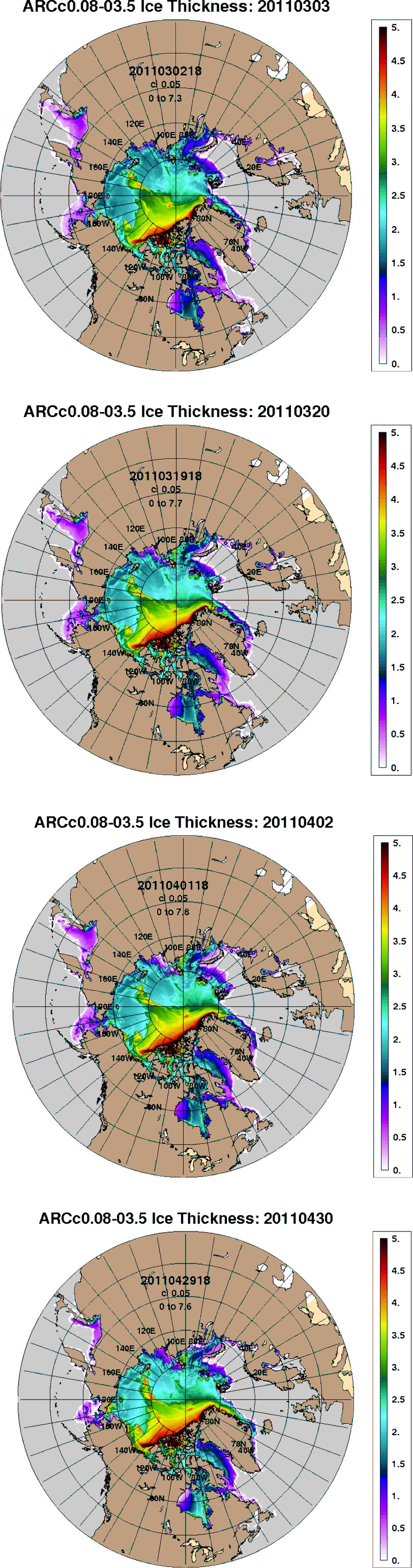
Figure 5. Ice thickness in the Arctic, the spring of 2011. Top to bottom: March 3, March 20, April 2, April 30 (2011). That bit of black you see in the tongue of multiyear ice (red and yellow) curling towards the shoreline of the Eastern Beaufort/Yukon (around “140W” on the maps) is ice that is 5 m thick! Note that these maps have only been available since 2011, see the Navy NRLSSC archive here). Click to enlarge.
Eventually, it seems to me, the thick multiyear ice being driven south by the wind-driven currents of the Beaufort Gyre compress the shorefast ice (which develops along the shallow coast of the continental shelf over the winter, 20 km wide in places, see Fig. 1) against the Eastern Beaufort/Yukon mainland coast and the west coast of Banks Island. Under the most extreme of these conditions, the shorefast ice becomes very thick, with fields of buckled ice and pressure ridges (see Fig. 2). These conditions make it difficult, if not impossible, for ringed seals to maintain their breathing holes: they have little choice but to move elsewhere, or perish.
Apparently, late fall and winter storms do something comparable: winds from the northwest can similarly compress the shorefast ice against the coast (Melling 2005). Stirling et al. (2008:abstract) claim that the thick ice that developed in 2004-2006 was due primarily to storms caused or exacerbated by more open water in late summer – which they pin on global warming:
“A possible underlying ecological explanation is a decadal-scale downturn in seal populations. But a more likely explanation is major changes in the sea-ice and marine environment resulting from record amounts and duration of open water in the Beaufort and Chukchi seas, possibly influenced by climate warming.”
I’ll deal with the proposed decadal-scale downturn in seal populations another time. But there was indeed a particularly severe storm in early 2005 (from the 9th to the 12th of January – which Melling (2005) called a “storm of the century” and Stirling et al. (2008) called a “once-in-50-years storm”) – and a few months later (in April) polar bear biologists encountered extensive “rubble fields” of thick, compressed ice and some bears in poor condition.
However, Steve Amstrup and colleagues (2006) also found bears in poor condition in early 2004 – the spring before this huge storm – when they blamed the poor condition of the bears they captured for the three incidents of cannibalism they recorded (previous post here). Work by Lois Harwood and colleagues confirm that ringed seals were also having trouble in 2004, the year before this mega-storm occurred (Harwood et al. 2012).
So, is it storms (with winds from the northwest) that cause the thick ice – or bouts of multiyear ice being transported onto the coast by the wind-driven currents of the ever-present Beaufort Gyre? Or some years, a bit of both?
There is no discussion of the role of the Beaufort Gyre that I could find in any of these papers describing Beaufort Sea storms and their effect on shorefast ice thickness in the critical late winter-through spring months.
Nevertheless, that thick shorefast ice in spring was associated with the declines in ringed seals and polar bears since the 1960s is not disputed. Discussing starving polar bears in 2004 and 2005, Stirling et al. (2008) remarked:
“The 1960s, 1970s, and 1980s each experienced a two- to three-year decline in seal productivity in the eastern Beaufort Sea and Amundsen Gulf, associated with heavy ice conditions, around mid-decade. Each was followed by a decline in polar bear reproduction and condition, after which both seal and bear populations recovered (Smith, 1987; Harwood et al., 2000; Stirling, 2002). The beginning of each of those three periods was associated with heavy ice conditions through the winter before the reproductive decline of the seals, followed by a late spring breakup.” [my bold]
Given this knowledge, why would these authors consider the event of the 2000s (2004-2006) as significantly different from previous events – different enough to blame the latest one on global warming but not the previous ones?
It’s all rather complicated and hampered severely by lack of comparable data for the entire period. With one exception…
There’s one historical perspective that’s especially useful. Ice thickness maps were produced in the early 1970s by the research team lead by Rene Ramseier (Ramseier et al. 1975) from Nimbus 5 passive microwave data. It appears to me, from these maps, that something similar to the spring of 2011 occurred during 1974 and 1975. Recall that 1974 was a very bad year for ringed seals and polar bears in this region, discussed previous here.
The maps below (Fig. 6) are from the Ramseier et al. report and they show the percentage of first year ice relative to multiyear ice (solid white areas on the maps) in February and March 1974, and January and March 1975. You can see the multiyear ice extend like a tongue down towards the Eastern Beaufort/Yukon mainland coast and also pushing against the west coast of Banks Island – both regions of extensive polar bear research at the time.
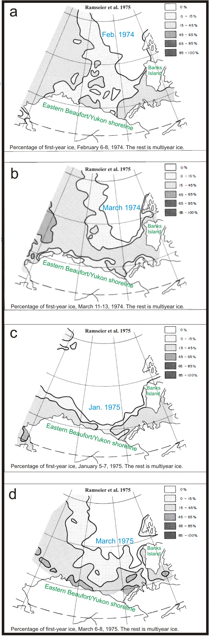
Figure 6. Ice thickness maps from Ramseier et al. 1975. The multiyear ice (white areas) seem to have impacted the west coast of Banks Island severely in the springs of both 1974 and 1975, while the coast of the Eastern Beaufort/Yukon mainland in the south may have been more severely impacted in 1975. Most of the sampling of polar bears in the 1970s occurred around Banks Island, with some along the Eastern Beaufort/Yukon coastline.
It appears to me that every few years in the first half of every decade, the amount of multiyear ice that is transported into the Eastern Beaufort in late winter and early spring by the Beaufort Gyre is greater than usual. Greater-than-usual amounts of multiyear ice compress the shorefast ice into a greater-than-usual thickness, which is unsuitable for ringed seals and consequently, devastating for polar bears. Storms may play a small role but it seems unlikely storms by themselves explain the phenomenon.
Finally, a few words about 2011 – was there an impact on ringed seals and polar bears as severe as 1974 or 1975?
While there have been no reports that I know of that suggest polar bears in the Eastern Beaufort had a hard time in the spring of 2011 because of the onshore movement of multiyear ice, the reality is we may never know. That’s because polar bear research efforts are now so focused on finding negative impacts of changes in summer sea ice extent that little, if any, work is being done in the critical spring period (Fish & Wildlife Service 2009; Polar Bear News 2010; Regehr et al. 2010; Rode and Regehr 2010).
How convenient – devastating impacts of thick spring ice (e.g. starving polar bears due to declines in ringed seals) will now likely be attributed to ‘effects of climate warming’ (i.e. reduced sea ice extent in late summer/early fall) simply because any bears in poor condition in the spring will likely remain in poor condition through the summer. Voilà! Poor condition correlates with reduced summer ice!
However, it is likely there will continue to be research on ringed seals in spring and early summer around Banks Island (e.g. Harwood et al. 2012), which will give us some way to track the phenomenon.
More on the impacts of this phenomenon on polar bear population numbers in my next post.
References
Amstrup, S.C., Stirling, I., Smith, T.S., Perham, C. and Thiemann, B.W. 2006. Recent observations of intraspecific predation and cannibalism among polar bears in the Southern Beaufort Sea. Polar Biology 29:997–1002. Pdf here.
Fish and Wildlife Service 2009. Ongoing polar bear research in Alaska. US Fish & Wildlife, Anchorage, AK. Pdf here.
Harwood, L.A., Smith, T.G., Melling, H., Alikamik, J. and Kingsley, M.C.S. 2012. Ringed seals and sea ice in Canada’s western Arctic: harvest-based monitoring 1992-2011. Arctic 65:377-390. http://arctic.synergiesprairies.ca/arctic/index.php/arctic/article/view/4236
Polar Bear News. 2010. Polar bear newsletter of the US Fish & Wildlife Service, Anchorage, Alaska. Pdf here.
Mahoney, A.R. 2012. Sea ice conditions in the Chukchi and Beaufort Seas. Pamphlet prepared for The Pew Charitable Trusts’ U.S. Arctic Program. Pdf here.
Melling, H. 2005. Sea ice, climate and Beaufort development. Presentation at the PERD/INAC Workshop, 1-3 November, Inuvik. “Northern Oil & Gas Research & Development in the Beaufort Sea.” Pdf available here.
Ramseier, R.O., Vant, M.R., Arsenault, L.D., Gray, L., Gray, R.B., and Chudobiak, W.J. 1975. Distribution of the ice thickness in the Beaufort Sea. Beaufort Sea Technical Report #30. Canada Dept. of Environment, Victoria, B.C. Available online.
Regehr, E.V., Hunter, C.M., Caswell, H., Amstrup, S.C., and Stirling, I. 2010. Survival and breeding of polar bears in the southern Beaufort Sea in relation to sea ice. Journal of Animal Ecology 79:117–127 http://onlinelibrary.wiley.com/doi/10.1111/j.1365-2656.2009.01603.x/abstract
Rode, K. and Regehr, E.V. 2010. Polar bear research in the Chukchi and Bering Seas: A synopsis of 2010 field work. Unpublished report to the US Fish and Wildlife Service, Department of the Interior, Anchorage. Pdf here.
http://arctic.synergiesprairies.ca/arctic/index.php/arctic/issue/view/42
Stirling, I., Richardson, E., Thiemann, G.W. and Derocher, A.E. 2008. Unusual predation attempts of polar bears on ringed seals in the southern Beaufort Sea: possible significance of changing spring ice conditions. Arctic 61:14-22. http://arctic.synergiesprairies.ca/arctic/index.php/arctic/article/view/3/3
Vibe, C. 1965. The polar bear in Greenland. In, Proceedings of the First International Scientific Meeting on the Polar Bear. Fairbanks, Alaska 6-10 September 1965, IUCN Polar Bear Specialist Group. University of Alaska International Conference Proceedings Series, No. 1. pg. 17-25. Washington, DC. Available here.


You must be logged in to post a comment.