
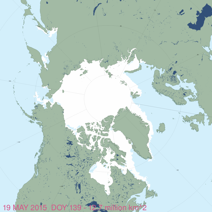
The map of sea ice extent in Canada at 20 May 2015 is an almost-perfect example of the placement of recurring patches of open water polynyas that were present in the Canadian Arctic at this time of year in 1975-1979. Notes from field work on shore leads in Hudson Bay ice at May, 1948 offer further insight into the current pattern of sea ice cover on the bay.
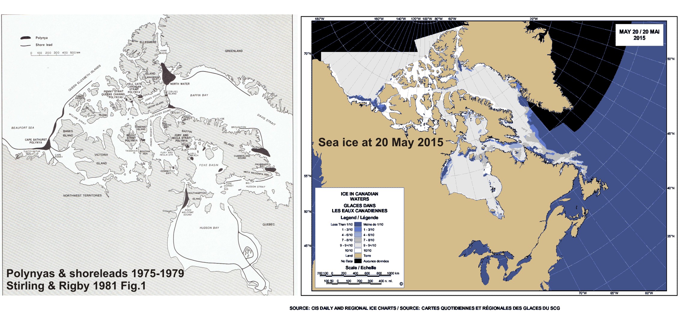
May is traditionally the time when recurring polynyas in the Canadian Arctic become more prominent and persistent shore leads (cracks in the ice near shore, also called “flaw leads”) become wider. Polar bears hunt around these polynyas because ringed and bearded seals congregate around them in the spring (Stirling et al. 1981; Stirling 1997). These polynyas are often not truly “open water” but covered by thin ice that’s easy for seals to break through.
Slight differences in location and size of polynyas and shore leads from year to year (especially in spring) are governed primarily by prevailing winds (Dunbar 1981:29) and to a lesser extent, currents. See my previous discussion on Beaufort Sea polynyas, with references: Beaufort Sea polynyas open two weeks before 1975 – open water is good news for polar bears.
This suggests that while sea ice cover over Hudson Bay and the Beaufort Sea is now a bit below average for this time of year (as the maps for this week show), it does not necessarily portend an earlier breakup or longer open-water period later in the year.
Dunbar (1981:32) had this to say about Hudson Bay’s persistent flaw leads:
“The largest flaw leads normally found in Canada are in Hudson Bay. The Hudson Bay lead, seaward of the fast ice, is so wide as to have generated the belief that the whole of the bay, except for the fast ice region along the shore, stayed unfrozen all winter…In the Hudson Bay instance, the myth of an open bay all winter was dispelled by Hare and Montgomery (1949), who showed that the pattern of of air temperatures over the whole region made an open Hudson Bay in winter very improbable. By overflying the area, they demonstrated that in fact the central bay is covered with ice in winter, although there normally exists a large flaw lead seaward of the fast ice on both sides of the bay and extending into northern James Bay. This flaw lead varies in width according to the direction of the wind from “about a mile and a half to 30 or 40 nautical miles” (Hare and Montgomery 1949).” [my bold]
Here is what Hare and Montgomery (1949:160, 163) said about Hudson Bay shore leads:
“The shore lead, which seems to have caused so much confusion in estimating the ice cover of Hudson Bay, may at times be entirely absent. Along the east coast from Great Whale River to Port Harrison the “Ice” reconnaissance of 8 March 1949 found no suggestion of open water. There were traces of old refrozen leads but none of them as large or as continuous as the one found along this same coast by the “Cariberg” reconnaissance of 6 May 1948. At that time the lane of open water off Port Harrison [now called Inukjuak, on the east coast] was 25 to 30 miles wide and seemed to stretch north and south along the coast as far as could be seen. It should be noted that this wide shore lead resulted after several days of NE winds which had effectively driven the ice offshore.” [my bold]
In contrast, this year, the shore lead is expanding on the western side.
Arctic melt progress (click maps and graphs to enlarge)
For Canadian waters, courtesy Canadian Ice Service (see maps in red, top left corner, for area covered by the graphs) [compare to last week here]
East Coast (regional), week of 21 May (1969-2015) – about average.

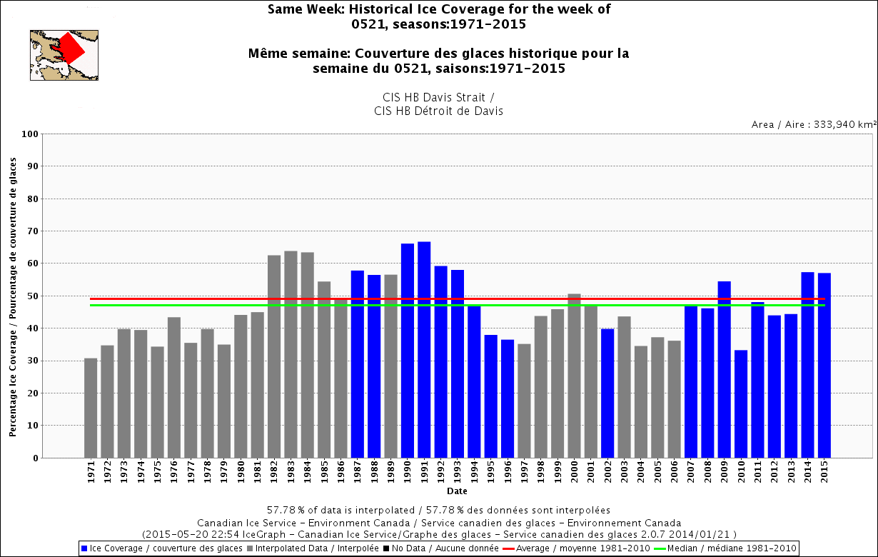
Davis Strait, week of 21 May (1969-2015), well above average.
Hudson Bay (regional), week of 21 May (1971-2015), just about average. 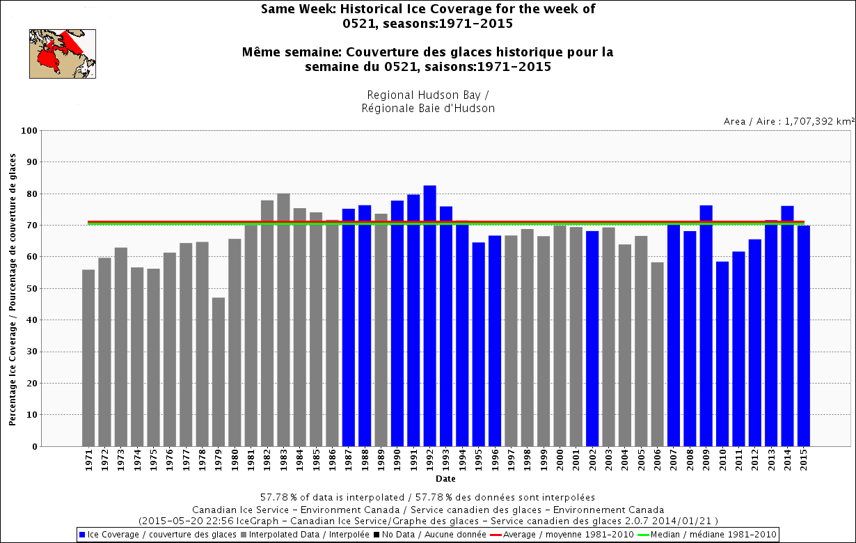
Hudson Bay only, week of 21 May (1971-2015), slightly below average. 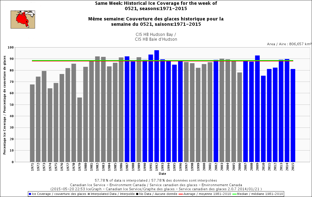
Beaufort Sea, week of 21 May (1968-2015), slightly below average. 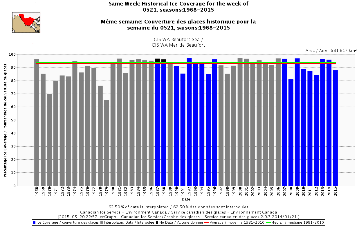
Sea ice extent and concentration for Barents Sea and East Greenland
Courtesy Norwegian Ice Service.
For 19 May 2015 – note the high ice concentration (red, “very close drift ice”) 
Compare to 19 May 2014:

Compare to 19 May 2009:

Sea ice extent for the entire Arctic, at 19 May 2015, courtesy NSIDC MASIE
Polynya map from Smith and Rigby 1981 below (click to enlarge):

Sea ice map for Canada at 20 May 2015 (click to enlarge):

References
Dunbar, M.J. 1981. Physical causes and biological significance of polynyas and other open water in sea ice. In: Polynyas in the Canadian Arctic, Stirling, I. and Cleator, H. (eds), pg. 29-43. Canadian Wildlife Service, Occasional Paper No. 45. Ottawa.
Stirling, I. and Cleator, H. (eds). 1981. Polynyas in the Canadian Arctic. Canadian Wildlife Service, Occasional Paper No. 45. Ottawa.
Smith, M. and Rigby, B. 1981. Distribution of polynyas in the Canadian Arctic. In: Polynyas in the Canadian Arctic, Stirling, I. and Cleator, H. (eds), pg. 7-28. Canadian Wildlife Service, Occasional Paper No. 45. Ottawa.
Stirling, I, Cleator, H. and Smith, T.G. 1981. Marine mammals. In: Polynyas in the Canadian Arctic, Stirling, I. and Cleator, H. (eds), pg. 45-58. Canadian Wildlife Service, Occasional Paper No. 45. Ottawa.
[Pdf of pertinent excerpts of above papers here]
Hare, F.K. and Montgomery, M.R. 1949. Ice, Open Water, and Winter Climate in the Eastern Arctic of North America: Part II. Arctic 2(3):149-164. http://arctic.journalhosting.ucalgary.ca/arctic/index.php/arctic/article/view/3985 Pdf here.
[see also: Hare, F.K. and Montgomery, M.R. 1949. Ice, Open Water, and Winter Climate in the Eastern Arctic of North America: Part I. Arctic 2(2):79-89. http://arctic.journalhosting.ucalgary.ca/arctic/index.php/arctic/article/view/3976 ]
Stirling, I. 1997. The importance of polynyas, ice edges and leads to marine mammals and birds. Journal of Marine Systems 10:9-21.


You must be logged in to post a comment.