Tag Archives: USGS

US biologists used same flawed models for listing walrus and polar bears as ‘threatened’

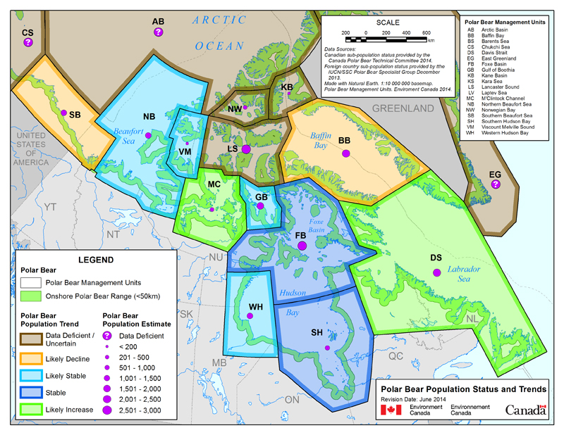
More bad science: US biologists successfully used a scientifically flawed model to get polar bears listed as ‘threatened’ and thus emboldened, went on to do the same for walrus.

Walruses_USFWS photo_030515_March 2015

The intricate US Geological Survey model of ‘expert opinion’ that was used to support the listing of polar bears as ‘threatened’ under the US Endangered Species Act (ESA) has been soundly rejected by the world’s leading conservation organization, the IUCN,1 which has has tightened its rules for using “future conditions” (e.g., effects of global warming) in generating Red List assessments. That IUCN condemnation means the USGS model was never “the best available science” for evaluating the status of polar bears  ̶  it was (and still is) substandard, inadequate science that makes a mockery of serious conservation efforts.

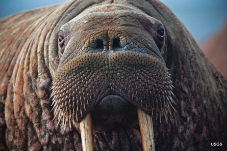
However, not only has this flawed model continued to be used by the USGS for polar bears, it has also been used to assess the conservation status of Pacific walrus, which are now officially “candidates” for being listed as ‘threatened’ (US Fish and Wildlife Service 2011).2

Continue reading

Supporting document for Canada’s polar bear status maps reveal surprises

My request to Environment Canada in early December 2014 for the documents supporting their polar bear status maps has finally generated results.

In an email dated 2 March 2015, I received the document produced by the EC Polar Bear Technical Committee (PBTC). I waited to see if it would be appended to the webpage where the maps were posted last year (reported here and here). However, as of today, that has not happened, so I am posting it here. There are some rather striking differences that may surprise you.

UPDATE 22 March 2015: A copy of the letter from the Director General of the Canadian Wildlife Service that accompanied the document below, which I forgot to include, is here. It states that the once a new status table has been compiled (provided below), “it is reviewed by the Polar Bear Administrative Committee and then becomes a public document.” The implication is that the reviewed document has not yet been produced.
Continue reading

Tracking polar bears in the Beaufort Sea – February 2015 map

Here is the February 2015 follow-up to my post on the July 2013 track map for female polar bears being followed by satellite in the Beaufort Sea by the US Geological Survey (USGS) – “Ten out of ten polar bears being tracked this summer in the Beaufort Sea are on the ice.”

polar_bear with collar_USGS

See that post for methods and other background on this topic, and some track maps from 2012 (also available at the USGS website here). The USGS track map for February 2015 is copied below.

There were 7 bears in February, up from 6 in January, because one of the bears has re-entered the area from elsewhere. However, many bears from the original sample have either had their collars fail, moved out of the area and stayed out, or they have died. We can’t tell from which of those options, or combinations of them, explain the reduced number still being followed.
Continue reading

Tracking polar bears in the Beaufort Sea – January 2015 map

Here is the January 2015 follow-up to my post on the July 2013 track map for female polar bears being followed by satellite in the Beaufort Sea by the US Geological Survey (USGS) – “Ten out of ten polar bears being tracked this summer in the Beaufort Sea are on the ice.”

Tranquilized_pb570_S Beaufort March 2014_USGS

See that post for methods and other background on this topic, and some track maps from 2012 (also available at the USGS website here). The USGS track map for January is copied below.

There are only 6 bears being followed now, which means a few more collars have failed, or the bears have moved out of the area or died.
Continue reading

Faux polar bear figures – my editorial in the National Post

Published in the Business section (Financial Post “Comments”) of the National Post this morning:

Paul J. Richards/AFP/Getty Images [NP story]

Paul J. Richards/AFP/Getty Images [from original NP essay]

“Faux polar bear figures” [not my choice of title, by the way]

In which I conclude:

We admire polar bear biologists for their professional dedication to this iconic species, and rightly so. However, while it’s understandable that polar bear biologists are conservation-minded, the public and policy makers need them to be scientists first and advocates for polar bear protection second. Polar bears are currently doing well – data shenanigans to keep them classified as “threatened” undermine the whole point of doing science.”

I have written extensively about the Southern Beaufort issue — below are links to some of these, which have links to the rest. References are included in these individual posts. Contact me if there is a reference you cannot find: Continue reading

Tracking polar bears in the Beaufort Sea – December 2014 map

Here is the December 2014 follow-up to my post on the July 2013 track map for female polar bears being followed by satellite in the Beaufort Sea by the US Geological Survey (USGS) – “Ten out of ten polar bears being tracked this summer in the Beaufort Sea are on the ice.”

Tranquilized_pb570_S Beaufort March 2014_USGS

See that post for methods and other background on this topic, and some track maps from 2012 (also available at the USGS website here). The USGS track map for December is copied below.

There are only 10 bears being followed now, which means a few more collars have failed, or the bears have moved out of the area or died.
Continue reading

Tracking polar bears in the Beaufort Sea – November 2014 map

Here is the November 2014 follow-up to my post on the July 2013 track map for female polar bears being followed by satellite in the Beaufort Sea by the US Geological Survey (USGS) – “Ten out of ten polar bears being tracked this summer in the Beaufort Sea are on the ice.”

See that post for methods and other background on this topic, and some track maps from 2012 (also available at the USGS website here). The USGS track map for November 2014 is copied below.

 Figure 1. Original caption: "Movements of 12 satellite-tagged polar bears for the month of November, 2014. Polar bears were tagged in 2014 on the spring-time sea ice of the southern Beaufort Sea. All twelve of these bears have satellite collar transmitters. Polar bear satellite telemetry data are shown with AMSR2 remotely-sensed ice coverage for 30 November, 2014." Click to enlarge, original here.


Original caption: “Movements of 12 satellite-tagged polar bears for the month of November, 2014. Polar bears were tagged in 2014 on the spring-time sea ice of the southern Beaufort Sea. All twelve of these bears have satellite collar transmitters. Polar bear satellite telemetry data are shown with AMSR2 remotely-sensed ice coverage for 30 November, 2014.” Click to enlarge, original here.

All twelve bears (all females) are finally visible on this map, confirming my suspicion that two were so close together they overlapped. Three out of the twelve “Southern Beaufort” bears were in the Chukchi Sea at the end of November (west of Point Lay, see discussion here). If you missed it, my October 2014 post on the progress of these bears has some maps from previous years that are worth reviewing.

Tracking polar bears in the Beaufort Sea – October 2014 map shows most ice since 2010

Here is the October 2014 follow-up to my post on the July 2013 track map for female polar bears being followed by satellite in the Beaufort Sea by the US Geological Survey (USGS) – “Ten out of ten polar bears being tracked this summer in the Beaufort Sea are on the ice.”

See that post for methods and other background on this topic, and some track maps from 2012 (also available at the USGS website here). The USGS track map for October 2014 is copied below (Fig. 1).

For the end of October, there was more ice in the Southern Beaufort this year than there has been since 2010.

Eight bears (all females) were on the ice and four were onshore. Only six of the eight on-ice bears were actually in the Southern Beaufort – the other two were in the Chukchi Sea (west of Point Lay, see discussion here).

Note that the recent boundary change between the Southern and Northern Beaufort subpopulations (the US/Canada boundary of the Southern Beaufort), reported here, has not addressed the fact that many western “Southern Beaufort” bears move into the Chukchi Sea. Continue reading

No proof walrus are “struggling from the loss of sea ice” as new Earthjustice lawsuit claims

A new day, a new lawsuit by environmentalists: this time, the species-on-a-pedestal is the same population of Chukchi Sea walrus that generated a news frenzy last month, which apparently still has legs.

Walrus puss_USGS_IMG_4763
Continue reading

Walrus mass haulout hype refuted, the video

Produced by the Global Warming Policy Foundation, there is now a short video summary of my recently-released GWPF briefing paper, which I wrote and narrated.

Walrus fuss_GWPF video Crockford

Watch it below:

Available also at GWPF TV“The Walrus Fuss – Walrus haulouts are nothing new.”

The briefing paper is here.

Save