Tag Archives: Chukchi Sea

Ancient polar bear skulls looted from Bering Sea graves to be returned

A different kind of polar bear news story caught my eye this morning: “Funerary polar bear skulls may be returned to St. Lawrence Island.”

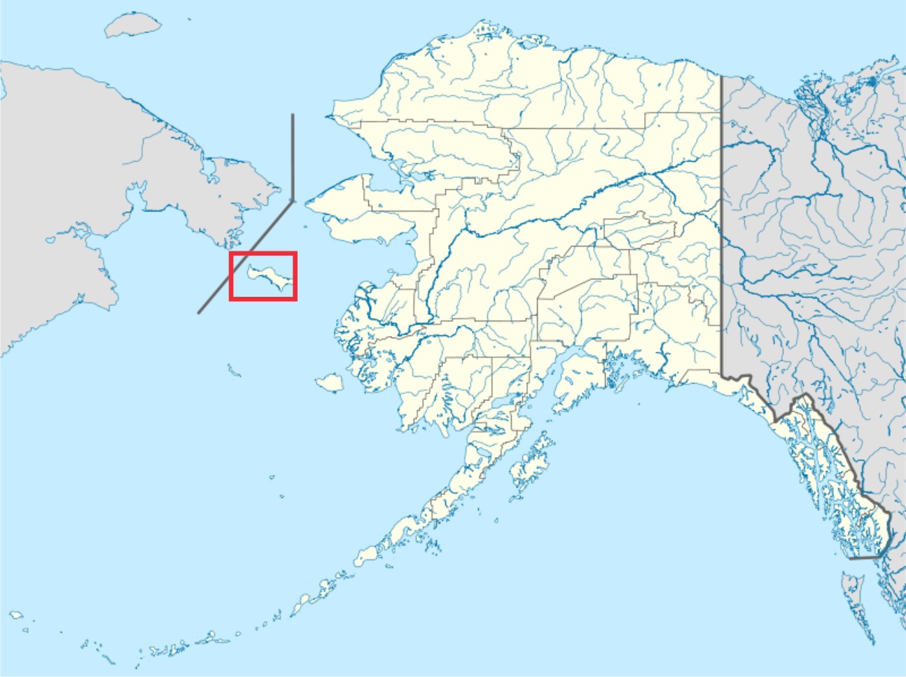
St. Lawrence Island, Alaska lies just south of the Bering Strait (see map below). It has strong historical ties to Russia but lies within US territory; it also lies within the “Chukchi Sea” polar bear subpopulation region.

St Lawrence island wikipedia marked

The story I found talks of “hundreds of polar bear bones, mostly skulls” that had been excavated from ancient human graves on St. Lawrence Island between 1930 and 1960. Hundreds!

These polar bear skulls and other bones had been stored separately from the carved ivory artifacts and other goodies plundered removed from graves (a formerly common practice). The museum in New York had only recently found them in storage and was preparing to return them, as the law now stipulates.

St. Lawrence Island is an important region for understanding the development of Inuit culture and the history of the Arctic. I could tell you a story about that (based on my peer-reviewed published papers) but I’ll save it for another long winter’s night.

However, my knowledge of the region meant I found the short online summary frustratingly devoid of detail, so I went a’Googling and found that a total of 376 polar bear skulls were involved. Worth the effort, I think – have a look.

[Update evening of December 12, 2013 – I’ve been mulling over in my mind all day whether using the word “looting” in my title (and in the text above, “plundered”) was warranted and decided in the end that it was perhaps not quite fair. To be sure, looting of graves and midden sites has occurred on a massive scale on St. Lawrence Island but Dr. Geist was doing archaeology as it was legally practiced in those days, and he did, on one occasion at least (see below), ask permission of relatives to remove items. Still, the people of St. Lawrence Island may well perceive all of the disturbance of their ancestors graves to be looting or plundering. So, I changed the “plundered” in the text to “removed” but left the title as I wrote it — as a reminder for readers to think about whether or not calling these actions “looting” is unfair.]
Continue reading

Tracking polar bears in the Beaufort Sea: October map

Here is the October follow-up to my post on the July track map for female polar bears being followed by satellite in the Beaufort Sea by the US Geological Survey (USGS) – Ten out of ten polar bears being tracked this summer in the Beaufort Sea are on the ice. See that post for methods and other background on this topic, and some track maps from 2012 (also available at the USGS website here).

The track map for October is copied below (Figure 1).

By the end of October, ice reached the coast in several areas. The ten bears from July were down to seven – their collars might have stopped working or fallen off (most likely), they might have left the area entirely (also possible) or they might have died (the researchers don’t say which).
Continue reading

Polar bear cannibalism and sea ice, the spring of 1976

Remember Ian Stirling’s claim that late freeze up in Western Hudson Bay in 2009 was forcing polar bears to resort to cannibalism (here and here), with gut-wrenching images and video provided for the media? Or Steve Amstrup’s claim for a similar phenomenon in the Southern Beaufort in 2004?

I pointed out that Stirling’s claim was way overblown and that Amstrup’s incidents were almost certainly the result of heavy ice in the spring (not low ice in summer), similar to the heavy ice conditions and polar bear starvation documented in the same region back in 1974-1976.

It turns out that the heavy ice conditions documented in the Eastern Beaufort in the mid-1970s had much broader effects on polar bears and ringed seals than has been appreciated.
Continue reading

Lancaster Sound – a rarely-mentioned region with a large polar bear population

The polar bear subpopulation designated as Lancaster Sound lies at the eastern entrance to the Northwest Passage in the Canadian High Arctic (Fig.1). We rarely hear about it but this region has one of the largest polar bear populations anywhere in the Arctic – only the Barents Sea and Foxe Basin have higher estimated population sizes.

Figure 1. Lancaster Sound, magenta. Map courtesy Polar Bear Specialist Group, additional labels added.

Figure 1. Polar bear subpopulations with Lancaster Sound marked. Map courtesy IUCN Polar Bear Specialist Group, additional labels added.

Lancaster Sound includes the communities of Arctic Bay on northwestern Baffin Island and Resolute Bay on Cornwallis Island. Devon Island, which lies on the northern boundary, has no permanent communities, although two research stations are present (see here and here). A more detailed map showing the exact boundaries is available in Vongraven and Peacock (2011).

The eastern portion of Lancaster Sound is generally clear of ice by late summer (hence the Northwest Passage) but the western third of the region not only retains pack ice later in the season but some multiyear ice remains throughout the year.

The proximity of Lancaster Sound to Baffin Bay and the eastern Northwest Passage (Fig.2) undoubtedly exposed polar bears there to hunting by European whalers during the 1800s and early 1900s (see previous post here, especially Fig. 5), from which the population appears to have recovered.

On the other hand, the proximity of Lancaster Sound to oil and gas reserves further north in the High Arctic generated much-needed funds for polar bear biologists in the mid-to-late 1970s to collect essential baseline data for the entire region (Schweinsburg et al. 1982; Stirling et al. 1979, 1984; Stirling and Latour 1978).

Figure 2. The main Northwest Passage route starts at Lancaster Sound and runs east through Parry Channel because these waterways routinely clear of ice in late summer. The approximate boundary of the Lancaster Sound polar bear subpopulation (area ~490,000 km2) is marked in yellow; POW is Prince of Wales Island. Map from Wikipedia, labels added.

Figure 2. The main Northwest Passage route starts at Lancaster Sound and runs east through Parry Channel because these waterways routinely clear of ice in late summer. The approximate boundary of the Lancaster Sound polar bear subpopulation is marked in yellow; POW is Prince of Wales Island. Map from Wikipedia, labels added. Click to enlarge.

Continue reading

What polar bear habitat could look like in another 5-6 weeks

According to the National Snow and Ice Data Center (NSIDC, Sept. 20 report), the annual sea ice minimum extent was reached on Sept. 13, 2013.

At 5.10 million square kilometers, this year’s low was a whopping 1.69 million square kilometers above the minimum extent for 2012 (which was the lowest since 1979) and well within two standard deviations of the 1979-2010 average. (Two standard deviations: “Measurements that fall far outside of the two standard deviation range or consistently fall outside that range suggest that something unusual is occurring that can’t be explained by normal processes”).

The minimum extent for 2013 is virtually indistinguishable from the minimum for 2009, which was 5.13 million square kilometers. The ice was distributed a bit differently in 2009 – more in the east and less in the west — than it was this year (see Fig. 1 below).

Figure 1. Using the JAXA “Sea ice monitor” feature, I plotted the date the 2013 minimum was reached (September 13, 5.10 million square kilometers, white) with an overlay (purple) for the same date back in 2009 (September 13, 2009, 5.13 million square kilometers), when that year’s minimum was reached (according to the NSIDC report). Areas of overlap are pink.

Figure 1. I used JAXA to plot the date the 2013 minimum was reached (September 13, 5.10 million square kilometers, white) with an overlay (purple) for the same date back in 2009 (September 13, 2009, 5.13 million square kilometers), when that year’s minimum was reached. Areas of overlap are pink.

You’ll know from previous discussions here that the annual minimum reached in late summer has little impact on polar bear health and survival (see excellent summary of the evidence for that here). What matters most to polar bears is the presence of ample ice in spring and early summer (March-June), which is their critical feeding period.

But after the fast that many polar bears endure over the height of the summer, they are eager to get back onto the ice and resume hunting. When in the fall does that become possible?

I wondered what the similarity in extent for 2013 and 2009 might tell us about polar bear habitat development over the next month or so.

In other words, what might polar bears this year expect in the way of sea ice development by say, the end of October? When might they be able to start hunting?

Continue reading

Polar Bear Specialist Group meeting postponed until 2014

[Update October 14, 2013: correction regarding Davis Strait population estimate, noted below]

I heard via the grapevine that the IUCN Polar Bear Specialist Group (PBSG) meeting, tentatively slated to be held this July (Obbard et al. 2010), has been postponed until 2014. [That will be the 16th Working Meeting, as they are called]

Word has it that shifting the meeting forward will allow the group time to put together a new population estimate that will incorporate recent survey results.

So which subpopulations are slated to be updated?

Figure 1. Polar bear subpopulations defined by the Polar Bear Specialist Group (PBSG). Note that Baffin Bay, Davis Strait, Western Hudson Bay and Southern Hudson Bay are all similar in that they become ice-free by early fall (the September minimum) or before.

Polar bear subpopulations defined by the Polar Bear Specialist Group (PBSG). Courtesy the PBSG.

As far as I can determine, there are at least two that haven’t quite been finished: Baffin Bay and Southern Beaufort. The Baffin Bay survey was supposed to be completed this spring, so the numbers just need to be crunched. Southern Beaufort has a survey in progress, planned to continue through the fall of 2013.

Here are some comments on the 2012 Southern Beaufort field season (USFWS Newletter 2013:17):

“The number of polar bears observed in 2012 was high relative to similar surveys conducted over the past decade. During August and September surveys, the majority of bears were observed east of Prudhoe Bay, primarily near Kaktovik. Body condition appeared relatively normal for this time of year with most bears reported to be in average condition.” [my bold] [see previous post here re: Kaktovik bears]

There are new counts for Foxe Basin (estimated at ~2,580 bears, similar to the early 1990s estimate of ~2,200; Stapleton, Peacock and Garshelis 2012) and Western Hudson Bay (estimated at ~1,000 bears, similar to the 2004 estimate of ~935; Stapleton, Atkinson et al. 2012) based on aerial surveys. These numbers have not yet been incorporated into the global total, although the studies suggest both of those populations have been stable since the last survey.

CBC News (June 26, 2012):

“A study has found that the polar bear population in the Foxe Basin region of Nunavut is stable and the bears are in good health.

The territorial government did an aerial survey of the bear population in 2009 and 2010. The survey results show the population is about the same size as it was in 1990 – about 2,580 bears.” [my bold]

There is also the new population estimate for Davis Strait (Peacock et al. 2013) that needs to be incorporated into the global total – in this case, there has been an increase from the previous estimate (up from ~1,400 to ~2,158). [corrected Oct. 14 2013] The population increase for Davis Strait has already been incorporated into the current global estimate. The new numbers were available by 2009 (the time of the last PBSG meeting) but the peer-reviewed publications (with all of the pertinent details) were not produced until recently (2012-2013, discussed here and here).
Continue reading

How and why great news about Chukchi polar bears has been suppressed

A new peer-reviewed report (Rode et al. 2014 [in print] 2013, accepted), released last month (announced here), documents the fact that polar bears in the Chukchi Sea are doing better than virtually any other population studied, despite significant losses in summer sea ice over the last two decades – even though the Polar Bear Specialist Group (PBSG) said this population was declining (Obbard et al. 2010).

Rode and Regehr 2010_Chukchi_report2010_Fig1_triplets_labelled

Rather than this good news being shouted far and wide, what we’ve seen so far is a mere whisper. The strategy for suppressing the information appears to have several parts: make it hard to find; don’t actively publicize it; down-play the spectacularly good nature of the news; minimize how wrong they were; keep the focus on the future.

Something similar happened with the newly-published paper on Davis Strait bears (Peacock et al. 2013, discussed here and here) but the news there wasn’t quite so shockingly different from expected. The suppression of good news stands in marked contrast to anything with a hint of bad news, which gets reported around the world — for example, Andrew Derocher and colleagues and their prepare now to save polar bears” policy paper in February, 2013.

US Fish & Wildlife biologist Eric Regehr, co-investigator of the Chukchi study and co-author of the newly-published report, wrote an announcement about the paper. It wasn’t a real press release, since it was not actually sent to media outlets. It was a statement, with a brief summary of the paper, posted on a regional US Fish & Wildlife website, with no mention of lead author Karyn Rode. Not surprisingly, lack of active promotion = no media coverage.

The posted announcement also down-played how well the Chukchi bears are doing. In fact, the news documented in the paper is much better than any of them let on: Chukchi polar bears are doing better than virtually all other populations studied.

But Regehr also had to do some damage control to counter the evidence this paper contains of how wrong they had all been — not only about the Chukchi population today but about their predictions for polar bears in the future.

After all, the computer models used to predict a dire future for polar bears combined the Chukchi Sea with the Southern Beaufort, as having similar ice habitats (“ice ecoregions”). The published paper and Regehr’s statement now say these two regions are very different and that polar bear response to loss of sea ice is “complex” rather than a simple matter of less summer ice = harm to polar bears. Regehr goes on to say that polar bear scientists expected this would happen. I call total BS on this one, which I explain in full later (with a map).

Finally, Regehr’s statement emphasizes that good news for 1 subpopulation out of 19 today should not be celebrated because the overall future for polar bears — prophesied by computerized crystal balls — is bleak. Focus on the future, they say. Did they forget that for years they’ve been telling us that polar bears are already being harmed and that this foreshadows what’s to come? Now we have the results of yet another peer-reviewed study showing bears not being harmed by declines in summer ice (see the full list here).

So, in the end, all of this double-talk and contradiction is not just about suppressing this particular paper. There’s much more at stake.

The Rode et al. Chukchi paper is strong evidence that their predictions of a grim future for polar bears – based on theoretical responses to summer sea ice declines that should already be apparent – have been refuted by their own studies. It’s no wonder they want to keep the media away from this story.

Details below.  [Update September 11, 2013: another news outlet picks up the story, see Point 2 below]

Continue reading

Tracking polar bears in the Beaufort Sea: August map

Here is the follow-up I promised to my post on the July track map for polar bears being followed by satellite in the Beaufort Sea by the US Geological Survey (USGS) – Ten out of ten polar bears being tracked this summer in the Beaufort Sea are on the ice. See that post for methods and other background on this topic, and some track maps from 2012.

The track map for August was posted on the USGS website on September 4th and is copied here below (Figure 1). The ice moved a bit further offshore during August but not nearly as far as it did in 2012. The ten bears from July were down to eight – their collars might have stopped working or fallen off (most likely), they might have left the area entirely (also possible) or they might have died (the researchers don’t say which).

 Figure 1. “Movements of 8 satellite-tagged polar bears for the month of August, 2013. Polar bears were tagged in 2013 on the spring-time sea ice of the southern Beaufort Sea. All 8 of these bears have satellite collar transmitters [i.e., all are females]. Polar bear satellite telemetry data are shown with Ice Analysis charts from 26 August, 2013. Ice Analysis charts are made available by the National Ice Center. The land cover is made available by Natural Earth. Click on the above image to enlarge.”[Note that the dots with the polar bear icons are the end points (end August), while the other end of the string is their position in early August. The yellow dot is behind the purple dot, on shore; two of the bears present in July (see Fig. 2 below) are no longer being tracked - their collars might have stopped working or fallen off (most likely), they might have left the area entirely (also possible) or they might have died. The researchers don’t say.]


Figure 1. “Movements of 8 satellite-tagged polar bears for the month of August, 2013. Polar bears were tagged in 2013 on the spring-time sea ice of the southern Beaufort Sea. All 8 of these bears have satellite collar transmitters [i.e., all are females]. Polar bear satellite telemetry data are shown with Ice Analysis charts from 26 August, 2013. Ice Analysis charts are made available by the National Ice Center. The land cover is made available by Natural Earth. Click on the above image to enlarge.” [Note that the dots with the polar bear icons are the end points (end August), while the other end of the string is their position in early August. The yellow dot is behind the purple dot, on shore; two of the bears present in July (see Fig. 2 below) are no longer being tracked – their collars might have stopped working or fallen off (most likely), they might have left the area entirely (also possible) or they might have died. The researchers don’t say.]

So, of the eight polar bears still being followed by USGS researchers in August, three were on shore and five were on the ice. Only time will tell if the three females on shore are pregnant and preparing maternity dens for the winter, but this seems the likely reason they are not on the ice with the others.

I’ll post the track map for September when it is available in early October at the USGS website.

The map for July 2013 is below, for comparison: Continue reading

Ten out of ten polar bears being tracked this summer in the Beaufort Sea are on the ice

PB_male on ice_Regehr USFWS_March 2010_labeledTracking Beaufort Sea polar bears over the summer — what can it tell us about how important the position of summer sea ice relative to the shoreline in this region is to these bears? Do Beaufort Sea bears get stranded on shore like the polar bears in Davis Strait and Hudson Bay?

Polar bear biologist Eric Regehr (with the US Fish & Wildlife Service, or FWS) has a team working with US Geological Survey researchers (USGS) in the southern Beaufort tracking where adult female polar bears go throughout the year. This is part of on-going research in the Beaufort and Chukchi Sea (see previous post here; see also Fish & Wildlife 2009; Polar Bear News 2010 and 2013; Rode and Regehr 2010, pdfs below; and just out, the “accepted” version of the Rode et al. paper discussed here, and announced in my last post here).

The researchers have been posting a summary map at the end of each month on the USGS website showing the tracks of the females they fitted with radio collars the previous spring — for 2013, and back to 2010. They can’t put collars on male bears because their necks are larger around than their heads, so a collar would just slip off.

I’ve posted the July 2013 track map below, which shows all ten bears out on the ice, and the previous month (June 2013) to compare it to (the August map should be out shortly). I’ve included a few maps from 2012 to allow you to compare this year’s results to the situation last summer.

The August tracks should be available after the Labour Day weekend – check back next week to see where the bears have been this month. I’ll post the map here or you can go to the USGS website directly. [UPDATE Sept 4, 2013: The August map is up, posted here.]

Continue reading

Good news about Chukchi Sea polar bears whispered by US Fish & Wildlife Service

Just out: the “accepted” version of the Rode et al. paper discussed here last month — detailing just how well polar bears in the Chukchi Sea subpopulation are doing, despite recent declines in sea ice.

However, what was decidedly odd was how I found out about it.

Yesterday (Aug 28), while looking for something else, I found a “press release” tweeted by World Wildlife Fund (WWF) employee Geoff York, who is now also a full voting member of the Polar Bear Specialist Group (PBSG).

Chukchi bears press release tweet_Geoff York Aug 28 2013

The announcement that York tweeted is listed as “alaska.fws.gov/external/newsroom/pdf/cs_polar_bear_article.pdf” and I found a stand-alone copy of the pdf with that title on Google.

However, FWS has so far (Aug. 29, 7:00 am PT) not mentioned this item on their [central] website, their twitter account, or their Facebook page (pdf here, with its original title). The “press release” has no date and is not on FWS letterhead but is authored by “Eric V. Regehr, U.S. Fish & Wildlife Service.” [I guess FWS employees can issue their own press releases?] UPDATE: Found it finally in the “FWS Alaska region” (Alaska FWS, posted Aug. 22, 2013, which included the Eric Regehr summary tweeted by York), via a news report at SitNews dated Aug. 27. Mystery solved]

Also odd that so far, no one except Geoff York himself seems to have picked it up (nothing so far on WWF website or Facebook page, Polar Bears International pages, or at ScienceDaily. [Update: see news report at SitNews dated Aug. 27. Still odd that the FWS report has been sitting there quietly since the 22nd (Thursday of last week)]

Not exactly how I’d choose to spread good news, but perhaps that’s the point.

Nevertheless, not too much new in the paper itself [contact me if you’d like a copy] – no population size estimate, for example – other than what I included in the summary provided last month (based on a March presentation by lead author Karyn Rode), except this: spring litter sizes [1.90 in 2007 and 2.17 in 2009 on Wrangel Island] were “are among the highest reported for 18 of 19 polar bear populations” and were similar to litter sizes 20 years earlier.

I guess the picture of the Chukchi female with a litter of triplet yearling cubs included without mention in the 2010 Rode and Regehr report (pdf here, copied below, discussed previously here) was significant after all.

Rode and Regehr 2010_Chukchi_report2010_Fig1_triplets_labelled

Continue reading