Environment Canada recently posted a set of maps on its website that show it has moved the boundary between the polar bear subpopulation it shares with the USA — without a word to the media or a note anywhere.
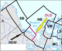

Environment Canada recently posted a set of maps on its website that show it has moved the boundary between the polar bear subpopulation it shares with the USA — without a word to the media or a note anywhere.
Comments Off on Beaufort Sea polar bear subpopulation boundary has been changed
Posted in Population
Tagged Alaska, boundary change, Environment Canada, Northern Beaufort, Northwest Territories, polar bears, population estimate, Southern Beaufort, subpopulations, Tuktoyaktuk
It is now clear that the phenomenon of bears moving across Southern Beaufort Sea![]() subpopulation boundaries compromised the US decision to list polar bears as ‘threatened’ and the IUCN Polar Bear Specialist Group (PBSG) knows that was the case.
subpopulation boundaries compromised the US decision to list polar bears as ‘threatened’ and the IUCN Polar Bear Specialist Group (PBSG) knows that was the case.
As I pointed out last week, the PBSG has admitted in their 2013 status table update (pdf here) that bears move around so much between the Chukchi Sea (CS), the Southern Beaufort (SB), and the Northern Beaufort (NB) subpopulations that major changes in the boundaries of the SB subpopulation are necessary (see Fig. 1 below).
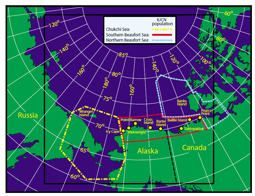
Figure 1. From the paper by Amstrup and colleagues (2005) describing the effect that movement of bears across subpopulation boundaries has on setting harvest quotas and population estimates. Southern Beaufort (SB) boundary is solid red, Chukchi Sea (CS) is dashed yellow and Northern Beaufort (NB) is dotted light blue. “Point Barrow” is Barrow, AK (well inside the SB boundary). Click to enlarge.
Well, that’s not really news — changes to the SB boundaries were promised by the PBSG back in 2009 (Obbard et al. 2010), based on research by Steven Amstrup and colleagues published in 2001 and 2005. But now, in an astonishing admission, the PBSG have acknowledged that the last population survey for the SB (Regehr, Amstrup and Stirling, 2006), which appeared to register a decline in population size and reduced cub survival over time, did not take known movements of bears into account as it should have done.
In other words, that 2006 study almost certainly did not indicate bears dying due to reduced summer sea ice in the SB, as biologists said at the time — and which they presented as evidence that polar bears should be listed by the ESA as ‘threatened’ — but reflected capture of bears that were never part of the SB subpopulation and so moved out of the region.
As the PBSG said about the 2006 estimate:
“…it is important to note that there is the potential for un-modeled spatial heterogeneity in mark-recapture sampling that could bias survival and abundance estimates.” [my emphasis]
“Spatial heterogeneity” means that the sampled bears could have come from more than one population, a possibility which violates a critical requirement of the statistics used to generate the population and survival estimates. “Un-modeled” means that the ‘movement of bears’ problem was not factored into the mathematical models that generated the 2006 population size and survival estimates as it should have been.
Ecologist Jim Steele pointed some of this out in his book and his guest post last year, so it’s not news that this was done.
What’s shocking is that the PBSG have now admitted that the ‘movement of bears’ issue essentially invalidates the 2006 population estimate and the much-touted ‘reduced survival of cubs.’ The reduced survival of cubs data from that SB study was a critical component of the argument that US bears were already being negatively impacted by global warming and thus, should be listed as ‘threatened’ under the ESA (US Fish & Wildlife Service 2008).
Since the population decline and reduced survival is now acknowledged to be unfounded — and perhaps deliberately so — I ask you this: will a new SB survey — soon to be released by the same lead author (Eric Regehr) — undo the broken trust in US and PBSG polar bear biologists? Continue reading
Comments Off on Southern Beaufort polar bear ‘decline’ & reduced cub survival touted in 2008 was invalid, PBSG now admits
Posted in Advocacy, Conservation Status, Population
Tagged abundance, Amstrup, Chukchi Sea, computer models, ESA, Jim Steele, migration, movements, Northern Beaufort, PBSG, Polar Bear Specialist Group, population estimate, population overlap, Regehr, Southern Beaufort, survival estimates, threatened, trust, US Fish and Wildlife Service
Here is the October follow-up to my post on the July track map for female polar bears being followed by satellite in the Beaufort Sea by the US Geological Survey (USGS) – Ten out of ten polar bears being tracked this summer in the Beaufort Sea are on the ice. See that post for methods and other background on this topic, and some track maps from 2012 (also available at the USGS website here).
The track map for October is copied below (Figure 1).
By the end of October, ice reached the coast in several areas. The ten bears from July were down to seven – their collars might have stopped working or fallen off (most likely), they might have left the area entirely (also possible) or they might have died (the researchers don’t say which).
Continue reading
Comments Off on Tracking polar bears in the Beaufort Sea: October map
Posted in Life History, Sea ice habitat
Tagged Beaufort Sea, Chukchi Sea, Northern Beaufort, polar bear movements, polar bears, satellite collars, Southern Beaufort, tracking polar bears
Here is the follow-up to my post on the July track map for polar bears being followed by satellite in the Beaufort Sea by the US Geological Survey (USGS) – Ten out of ten polar bears being tracked this summer in the Beaufort Sea are on the ice. See that post for methods and other background on this topic, and some track maps from 2012 (also available at the USGS website here).
The track map for September was posted on the USGS website on October 17 (delayed due to the US government shutdown) and is copied here below (Figure 1). The ice rebounded during the second half of the month (after the annual minimum was reached on September 13). The ten bears from July were down to eight – their collars might have stopped working or fallen off (most likely), they might have left the area entirely (also possible) or they might have died (the researchers don’t say which).
Figure 1. Original caption: “Movements of 8 satellite-tagged polar bears for the month of September, 2013. Polar bears were tagged in 2013 on the spring-time sea ice of the southern Beaufort Sea. All 8 of these bears have satellite collar transmitters [i.e., all are females]. Polar bear satellite telemetry data are shown with Ice Analysis charts from 26 August, 2013. Ice Analysis charts are made available by the National Ice Center. The land cover is made available by Natural Earth. Click on the above image to enlarge.” [Note that the dots with the polar bear icons are the end points (end September), while the other end of the string is their position in early September, indicating that the ice is now moving towards the shore. The pink dot present in August is almost entirely obscured by the purple dot, which is overlapping the yellow dot on shore in Alaska; also, the light brown dot is on Banks Island, far right.]
The map for July 2013 is below, for comparison: Continue reading
Comments Off on Tracking polar bears in the Beaufort Sea: September map
Posted in Life History, Sea ice habitat
Tagged Beaufort Sea, denning females, Eastern Beaufort, females with radio collars, habitat, Northern Beaufort, polar bears, sea ice extent, Southern Beaufort, summer ice minimum, summer sea ice, tracking polar bears, tracking polar bears by satellite, USGS
![]() We know that thick-ice springs occurred in 1974, 1975, 1986, 1992, 2004, and 2005 in the former ‘Eastern Beaufort’ – now the southern portion of the ‘Northern Beaufort’ and the eastern portion of the ‘Southern Beaufort.’ We know that these severe spring ice conditions negatively impacted both polar bears and ringed seals in this region every decade since the 1960s because the effects have been documented by numerous studies conducted in April through May for polar bears (Amstrup et al. 2006; Cherry et al. 2009; Pilfold et al. 2012; Stirling 2002; Stirling and Lunn 1997; Stirling et al. 1980; Stirling et al. 1993; Stirling et al. 2008) and in June and July for ringed seals (Harwood et al. 2012; Smith 1987), see previous posts here, here, and here.
We know that thick-ice springs occurred in 1974, 1975, 1986, 1992, 2004, and 2005 in the former ‘Eastern Beaufort’ – now the southern portion of the ‘Northern Beaufort’ and the eastern portion of the ‘Southern Beaufort.’ We know that these severe spring ice conditions negatively impacted both polar bears and ringed seals in this region every decade since the 1960s because the effects have been documented by numerous studies conducted in April through May for polar bears (Amstrup et al. 2006; Cherry et al. 2009; Pilfold et al. 2012; Stirling 2002; Stirling and Lunn 1997; Stirling et al. 1980; Stirling et al. 1993; Stirling et al. 2008) and in June and July for ringed seals (Harwood et al. 2012; Smith 1987), see previous posts here, here, and here.
For example, even though Ian Stirling and colleagues argued in their 2008 paper that the thick spring ice conditions in 2004, 2005 and 2006 (but not those in previous decades) were caused by storms initiated or intensified by greater amounts of open water in previous summers, they did not deny that the thick-ice springs occurred. They stated quite clearly that:
“The 1960s, 1970s, and 1980s each experienced a two- to three-year decline in seal productivity in the eastern Beaufort Sea and Amundsen Gulf, associated with heavy ice conditions, around mid-decade. Each was followed by a decline in polar bear reproduction and condition, after which both seal and bear populations recovered (Smith, 1987; Harwood et al., 2000; Stirling, 2002). The beginning of each of those three periods was associated with heavy ice conditions through the winter before the reproductive decline of the seals, followed by a late spring breakup.” [my bold]
So, I have to say, I was shocked but not surprised to find that in the more recent scientific literature, the phenomenon of thick-ice springs every decade in Southern and Northern Beaufort has been deliberately ‘disappeared.’
Not surprised because I suspected it had happened — this issue was a feature of the Stirling and Derocher (2012) paper from late last year which was the topic of my very first blog post, “Cooling the polar bear spin.”
However, I think it is important to document how the transmogrification of sea ice effects on polar bears was managed in the scientific literature so that everyone can see exactly what has been done. In a truly astonishing move for what is supposed to be a field of science, thick-ice springs have been effectively replaced by an open-water red herring as the scourge of Southern Beaufort polar bears.
Comments Off on Great polar bear red herring in the Southern Beaufort
Posted in Advocacy, Conservation Status, Sea ice habitat
Tagged Beaufort Sea, Cherry, Derocher, Eastern Beaufort, heavy sea ice, Northern Beaufort, open water, Regehr, ringed seals, Rode, Southern Beaufort, status, Stirling, summer ice minimum, thick spring ice
Now that we have a plausible explanation (previous post here) for why shorefast ice in the Eastern Beaufort got too thick for ringed seals every ten years or so, it’s time to talk about the effect that this recurring sea ice phenomenon might have had on polar bear population numbers.
We know from the reports of polar bear biologists that without fat young seals to eat in the spring, some bears in those thick-ice springs came close to starving and many mothers lost all or most of their cubs (Amstrup et al. 2006; Stirling 2002; Stirling and Lunn 1997; Stirling et al. 1980; Stirling et al. 2008). This presumably had some impact on population numbers – the question is: how bad was it?
None of the reports on the effects of the thick ice have given us any indication of how many polar bears might have died or lost their cubs. However, Ian Stirling and colleagues (Stirling et al. 2011) recently published a paper on the Northern Beaufort subpopulation that looked, at first glance, to have done just that.
You have to keep in mind that the geographic area in question – the Eastern Beaufort – is not an official polar bear subpopulation region – at least, not any more. As Fig. 1 below shows, the Eastern Beaufort was once its own, strictly Canadian region (or at least, a strictly Canadian research region) see previous post here), but management is now shared between two subpopulations and managed by two governments (Canada and the USA). About half of the bears of the “Eastern Beaufort” reside in the ‘Northern Beaufort’ subpopulation and the other half live in the ‘Southern Beaufort’ subpopulation.
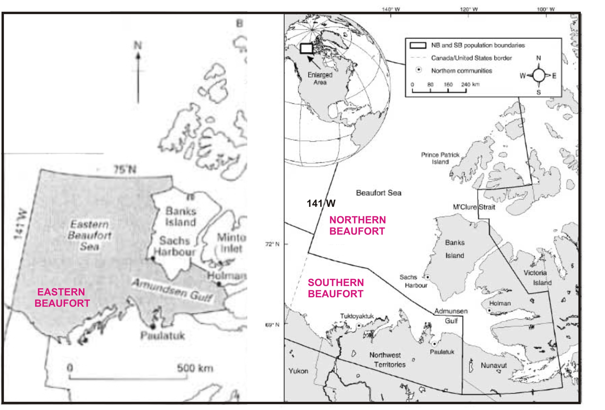
Figure 1. Re-jigging of polar bear subpopulations now splits what used to be an entirely a Canadian research segment, called the “Eastern Beaufort” (map on the left, from Stirling and Lunn 1997), into management regions called “Southern Beaufort” (shared with the USA) and “Northern Beaufort,” with the Canada-USA border at 141 W (map on the right, from Stirling et al. 2011, Fig. 1). Labels added. Most of the polar bears sampled for the Stirling et al. paper were captured along the west and south coasts of Banks Island, although a few were captured in M’Clure Strait and in Amundsen Gulf.
Despite the changing boundaries, ringed seals and polar bears in the Eastern Beaufort have been the focus of research since the early 1970s. In part, this is because the region has been targeted for oil exploration and studies on both species have been part of the associated ecological impact assessments (Stirling et al. 1993).
Getting back to the point, did Stirling et al. 2011 find fluctuations in polar bear numbers in the Northern Beaufort that might reflect the periodic bouts of thick spring ice in the Eastern Beaufort? Unfortunately, no — the data lack necessary precision. You’ll see why, I think, from the summary below. Continue reading
Comments Off on Did polar bear numbers in E. Beaufort fluctuate each decade due to thick ice years?
Posted in Population, Sea ice habitat
Tagged Amundsen Gulf, Banks Island, Eastern Beaufort, Ian Stirling, ice thickness, Northern Beaufort, population estimates, population numbers, Southern Beaufort, thick spring ice


You must be logged in to post a comment.