Tag Archives: temperature

Historic hot spells in Churchill, Polar Bear Capital of the World, in late June/early July

Amid reports of a late June heat wave in Europe this year, I thought I would check out the temperature in Churchill, Manitoba – where sea ice off the coast has been rather slow to melt this year with no reports yet of polar bears onshore. It turns out that Churchill has fairly often seen very hot weather (around 900F/300C) for a few days at this time of year but 2019 has certainly not been one of them. Temperatures in Churchill on 28 June this year were about 40 degress F below previous highs (more than 15 degrees C) according to online Environment Canada weather comparison reports that go back to 1943 (although their records for Churchill go back to 1929).

Polar bear on ice_SARA registry webpage_gov Can

High for 28 June 2019: 44.4 F/7.1 C

Hottest year, late June: 90.0 F/32.2 C on 29 June 1984 [also 87.8 F/30.6 C on 26 June 1967]

Hottest year, early July:  93.0 F/33.9 C on 4 July, 1975 [also 91.0 F/32.8 C on 3 July 1976]

Bottom line: It is appropriate to scoff at anyone who claims it never got hot in the Arctic before sea ice declined markedly around the turn of the 21st century. For Churchill (self-proclaimed Polar Bear Capital of the World), there are plenty of records of brief spells of hot weather in late spring/early summer (as well as in other months) that go back to the decades when sea ice conditions were supposedly ideal for polar bears.

Continue reading

Does thick first year ice on Hudson Bay mean a late date ashore for WH polar bears in 2018?

Following up on my previous post, it appears sea ice conditions on Hudson Bay this year might be headed for a late breakup due to the dominance of thick first year ice. That would mean a relatively longer on-ice season for polar bears in Western and Southern Hudson Bay.

James Bay female and cub_Ontaro Govt

As of the 1st week in May 2018, most of Hudson Bay, Foxe Basin and Hudson Strait were covered with thick 1st year ice (dark green, >1.2 m thick):

Hudson Bay weekly stage of development 2018 May 7

Compare that to the 1st week of May 2016, which had much less thick first year ice than 2018 and more medium first year ice (70-120cm, bright green):

Hudson Bay ice stage of development weekly at 9 May 2016

To update the situation, at the end of May this year (week of 28 May), thick first year ice covered even more of the bay with a large patch of open water in the NW corner:

Hudson Bay weekly stage of development 2018 May 28

Thick first year ice does not melt as quickly as medium or thin first year ice (lime green) under most conditions, so the amount of thick first year ice present in May strongly affects the rate of breakup of the ice over the summer (temperature and wind also contribute). Here are some charts of ice melt sequences from the past (2016 and a couple others) that give a hint at what might be in store for Hudson Bay polar bears this year.

Continue reading

Histrionics over Arctic temperatures & sea ice extent: implications for polar bears

Panic over Arctic temperatures got smeared across news networks last week, so I think a bit of perspective is in order, including an assessment of what this means for polar bears and their prey (because some of the hysteria is being amplified from that corner).

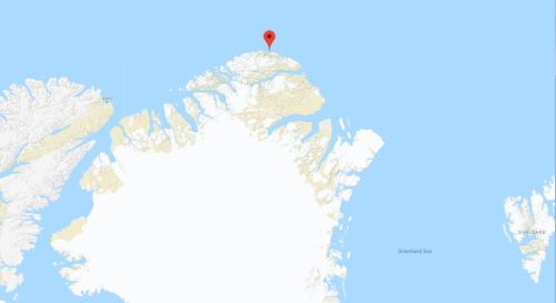
The region causing all the kerfuffle is at the northernmost tip of Greenland (see map below), where there is a weather station at Cape Morris Jesup. Next-nearest stations are at Alert, Canada (to the west) and Longyearbyen, Svalbard (Norway, to the east).

Cape Morris Jesup location Greenland_Google map

Arctic temps spike over 30 degrees in the midst of winter (The Weathern Network, Friday, February 23, 2018) included the tweet below, showing a fracture of sea ice north of Greenland so transient that it does not show up on daily sea ice maps:

“Along with those spikes in temperature, Lars Kaleschke’s tweet, above, also shows the large rift in the sea ice that opened up just north of Cape Morris Jesup, at the same time. Kaleschke is a professor of sea ice remote sensing at the Center for Earth System Research and Sustainability, at the University of Hamburg, in Germany.

Summary: Temperature and sea ice “abberations” in northern Greenland are transient phenomena that have clearly happened before (e.g. 2011) without major consequences except perhaps through impacts on eastern Arctic and subArctic weather conditions (including the UK).

Lack of sea ice north of Svalbard in the Barents Sea occuried last year and in 2012 in Februrary. But by mid-to-late March, when seal are beginning to give birth on the ice and polar bears are busy hunting them, ice had again covered the region. This year is likely to be the same. However, we won’t know until the end of March or ealry April if a recovery will or won’t happen, so any alarm-ringing about impacts on Arctic fauna surival have no foundation in fact until then.

East Greenland Scorsby Sound March 2011 on Kap Tobin_Rune Dietz_press photo

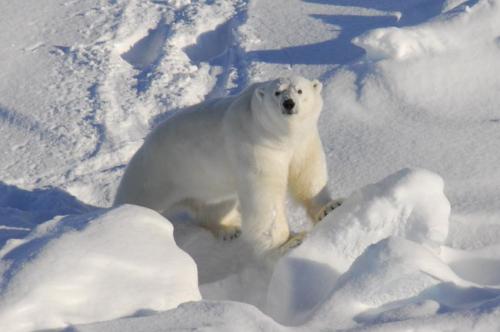
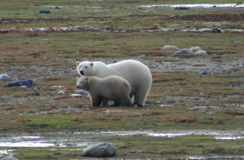
Scorsby Sound, East Greenland bear in March 2011. Rune Dietz, press photo.

In the Bering Sea, ice extent is well below average for this time of year but studies show the one consistent feature of Bering Sea ice is its variability. Low ice levels have distressing impacts for St. Lawrence island seal and whale hunters. However, there is certainly enough ice in the Bering Sea/Chukchi Sea region for polar bears and Arctic seals to do what they do this time of year (which is try to survive until early April, at which time seals start giving birth to their pups and polar bears start to eat them, with gusto). And the ice season isn’t over: maximum extent of ice in the Bering sea doesn’t usually come until late April or May, and the dramatic decline of mid-February already shows signs of reversing.

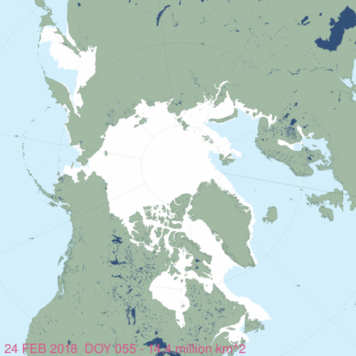
Details below this ice map for 24 February 2018, courtesy NSIDC Masie:

masie_all_zoom_4km 2018 Feb 24

PS. I’m off within hours to Toronto for the launch of my State of the Polar Bear Report in honour of International Polar Bear Day, 27 February. Watch for reports in the news and for my op-ed 27 February at the Financial Post.

Continue reading

Churchill polar bear reports still showing fewer problems than last year

Churchill, Manitoba’s Polar Bear Alert Program is still reporting many fewer problems with polar bears onshore than it did last year at the same point in the ice-free season (week 5, 7-13 August):

Churchill PB reports_week 5_ Aug 7-13_2017

Compare to week five last year (2016), when bears came ashore in excellent condition:

2016 Aug 8-14_week 5

Although it’s been warmer than average recently (25.4 degrees C yesterday, expected to reach 29 degrees C today and 28 degrees C tomorrow), according to Environment Canada weather records, that’s not even close to an August record-breaker temperature for Churchill. Continue reading