
The Canadian Ice Service has a cool NASA animated video showing the Beaufort Gyre in action – you can actually see the solid mass of ice crack and swirl west and north under the pressure of the massive corkscrew current – see original here (tips on getting yourself oriented in the video below the screencap) and view below, for Apri 4- May 3, 2016:
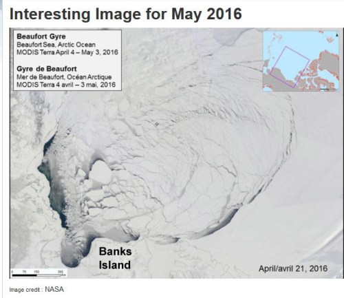
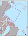
Note that the video is oriented with Banks Island on the bottom and the shore of Alaska along the left-hand side, as if the locator map provided was rotated as below:
The big ‘bite” of ice being torn out to the south of Banks Island is the Amundsen Gulf.
The caption for the NASA video says this (my bold):
“MODIS Terra imagery taken between April 4 and May 3, 2016 of the Beaufort Sea. The animation highlights the gradual ice breakup due to the Beaufort gyre.”
So, early breakup here is due to Beaufort Gyre action – not early seasonal melt.
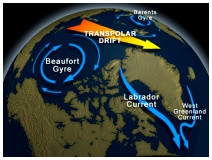
A simplified graphic of the Beaufort Gyre in relation to Arctic circulation (from Athropolis):
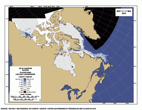
Here’s how that open water looks on the Canadian Sea ice map for 11 May 2016:
Here it is according to the NASA Worldview imagery (for 9 May, due to clear skies; my labels):

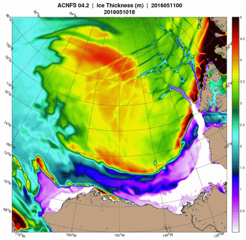
Two maps from the US Naval Research Lab shows how ice thickness has changed between early April (7 April, below) and early May (11 May 2016, follows). The fracturing of the ice is evident in the most recent image and makes it clear it is not only thin ice that is breaking – there is fracturing in 3.5-4.0 m and even 5.0 m thick ice as well as in the thinner (see more maps at the WUWT Sea Ice Page):

As I pointed out in my last post, open water at this time of year is generally good news for polar bears because it’s good news for seals, which I discussed last year in relation to open water in spring:
“…here is what marine mammal biologists Ian Stirling and colleagues had to say about polar bears and the Cape Bathurst polynya in spring (Stirling et al. 1981:49):
“Polar bears prey mainly upon ringed seals and, to a lesser degree, on bearded seals. Polar bears appear to be more abundant in polynya areas and along shoreleads, probably because the densities of seals are greater and they are more assessable. For example, between March and June in the Beaufort Sea from 1971 through 1975, 87% of the sightings of polar bears were made adjacent to floe edges or in unstable areas of 9/10 or 10/10 ice cover with intermittent patches of young ice.” [my bold]
Later, they discussed why these areas of open water can be so important in the Southern Beaufort area (Stirling et al. 1981:54):
“One useful approach is to ask what would happen if the polynya was not there? Obviously this is impossible to evaluate on an experimental basis, but by examining the consequences or natural seasonal variation, some useful insights can be gained. For example, the influence of rapidly changing ice conditions on the availability of open water, and consequently on populations of seals and polar bears, has been observed in the western Arctic. Apparently in response to severe ice conditions in the Beaufort Sea during winter 1973-74, and to a lesser degree in winter 1974-75, numbers of ringed and bearded seals dropped by about 50% and productivity by about 90%. Concomitantly, numbers and productivity of polar bears declined markedly because of the reduction in the abundance of their prey species. …If the shoreleads of the western Arctic or Hudson Bay ceased opening during winter and spring, the effect on marine mammals would be devastating.”[my bold]
In other words, Stirling and colleagues suggested in 1981 that the marked declines in ringed seal, bearded seal and polar bear numbers in the mid-1970s (discussed many times on this blog – most recently here) was due primarily to the fact that the Cape Bathurst polynya did not develop as usual because thick ice conditions prevented it.
Polynya references cited above are in that post (Tracking polar bears in the Beaufort Sea in April 2016 and early polyna formation).
It’s possible the kind of open water we’re seeing this spring is good for seals but not so good for polar bears but that remains to be seen. As far as I know, this is a new situation that has not previously been witnessed with this kind of precision – it doesn’t mean it has never happened before, just that we have never been able to watch it happen.
But if it’s bad news for polar bears, it will only serve to emphasize how critical spring conditions are for the bears – if more individuals than usual cannot feed as intensively as they need to, they will have trouble making it through the summer and winter later in the year. However, conditions would have to be exceedingly bad to be more harmful to polar bears than thick spring ice conditions, such as occurred in 1974-76 and 2004-2006, when many, many bears died of starvation.


You must be logged in to post a comment.