Tag Archives: NASA

New paper says Baffin Bay polar bears may have been affected by less summer sea ice

A new paper on Baffin Bay polar bears reports data on body condition and litter sizes collected as part of a major study of the region completed in 2013 compared to sea ice declines since the 1990s; based on a computer model, the authors predict that in 37 years time (if sea ice declines continuously), the incidence of twin litters could “largely disappear.” However, no decline in population numbers was predicted and a critical caveat acknowledges that factors other than changes in sea ice could have affected the body condition and litter size data the authors analyzed, which means the conclusions are scientifically inconclusive.

polarbearatthulerobindavies-500x349-sm

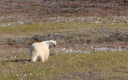
Fat polar bear, summer 2012 near Thule, NW Greenland (Baffin Bay subpopulation). Robin Davies photo.

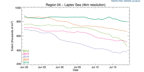
The last (2013) polar bear population survey of Baffin Bay (SWG 2016) generated an estimate of almost 3,000 (2,826; range 2,059-3,593), which means that regardless of some slight changes in body condition and litter size over the last two decades (which may or may not have been caused by loss of sea ice), there are currently a lot of bears in Baffin Bay.

Continue reading

At the winter maximum, still about the same polar bear habitat this year as 2006

There is no evidence that slightly less winter sea ice than the average since 1979 has had any negative impact on polar bear health or survival: the difference is simply not biologically meaningful to Arctic animals.

PB_male on ice_Regehr USFWS_March 2010_labeled

Polar bear on winter sea ice around the yearly maximum in the Beaufort Sea, 2010 (March 21).

NASA’s 23 March 2018 announcement regarding the Arctic sea ice maximum this year:

“Sea ice in the Arctic grew to its annual maximum extent last week, and joined 2015, 2016 and 2017 as the four lowest maximum extents on record, according to scientists at the NASA-supported National Snow and Ice Data Center (NSIDC) and NASA.”

Except, what they don’t tell you is that 2006 had almost the same extent as 2018 and 2006 wasn’t far behind according to the official, averaged data presented at NSIDC’s Arctic Sea Ice News & Analysis:

Arctic sea ice Maximum 10 lowest extents_NSIDC 23 March 2018

Current conditions at the winter maximum (at 17 March 2018, from NSIDC Masie, extent measured at 14.7 mkm2, using software able to discern more ice than used for the figures in Table 1), shown below: Continue reading

Arctic melt ponds get media spotlight as Laptev Sea ice hits an 11 year high

PolarBearCV1_USGS_2009

Walt Meier, sea ice scientist at NASA Goddard, made a statement yesterday about this year’s ice conditions [2016 Climate Trends Continue to Break Records: July 19, 2016]:

“It has been a record year so far for global temperatures, but the record high temperatures in the Arctic over the past six months have been even more extreme,” Meier said. “This warmth as well as unusual weather patterns have led to the record low sea ice extents so far this year. [my bold]

Well, except for Davis Strait/Labrador Sea this spring. And Western Hudson Bay/Foxe Basin this month – plus the fact that late July sea ice in the Laptev Sea is higher than it’s been for more than a decade (more on that below).

r04_Laptev_Sea_ts_4km 2016 July 19

I guess totals matter for some things – just not for polar bears. However, it’s nice to see the issue of melt ponds get some attention, since they are such a prominent feature of polar bear habitat during the summer melt season.

Continue reading

Beaufort Sea fractured ice due to strong Beaufort Gyre action – not early melt

The Canadian Ice Service has a cool NASA animated video showing the Beaufort Gyre in action – you can actually see the solid mass of ice crack and swirl west and north under the pressure of the massive corkscrew current – see original here (tips on getting yourself oriented in the video below the screencap) and view below, for Apri 4- May 3, 2016:

Beaufort Gyre video screencap_21 April 2016_labelled

Note that the video is oriented with Banks Island on the bottom and the shore of Alaska along the left-hand side, as if the locator map provided was rotated as below:

Beaufort Gyre video screencap_locator map_rotated

The big ‘bite” of ice being torn out to the south of Banks Island is the Amundsen Gulf.

The caption for the NASA video says this (my bold):

“MODIS Terra imagery taken between April 4 and May 3, 2016 of the Beaufort Sea. The animation highlights the gradual ice breakup due to the Beaufort gyre.

So, early breakup here is due to Beaufort Gyre action – not early seasonal melt.
Continue reading