
Last week biologist Andrew Derocher recently implied via twitter that less sea ice in the eastern portion of the Southern Beaufort (SB) this year at mid-May is harmful to polar bears (calling it “a hole in the ice where polar bears used to live“), but both long-term and short-term data don’t support such a glass-half-empty interpretation.
Not only does spring breakup of sea ice in the SB normally begin with such open patches of water (see the video above from last year) — driven by the powerful currents of the Beaufort Gyre, not ice melt (explained in detail here) — it may actually be necessary for the survival of local seals, polar bears and whales in spring and early summer (Citta et al. 2015; Crawford et al. 2015; Harwood et al. 2015; Stirling et al. 1981).
As I’ve pointed out before, the biggest threat to SB bears is thick sea ice in spring and its associated late breakup, a 2-3 year-long phenomenon unique to this region known to have occurred about every 10 years since the early 1960s (well documented in the scientific literature) but which has not (as far as I know) happened since 2004-2006.
In other words, a considerable patch of open water and less concentrated ice in the eastern SB around Cape Bathurst is almost certainly a good thing for this particular subpopulation (see previous post here for an in-depth discussion) because historically, when a polynya of some extent has not formed by April or May it has been devastating for local marine mammals.
The fact that an extensive patch of open water existed at mid-May in this region last year and the year before (2015 and 2016) — with no public hue-and-cry about a great dying of SB bears from Derocher or anyone else — suggests that open water in the eastern SB this year is likely to be beneficial for SB polar bears, or at least benign.
Here is what marine mammal biologists Ian Stirling and colleagues had to say about polar bears and the Cape Bathurst polynya in spring (Stirling et al. 1981:49):
“Polar bears prey mainly upon ringed seals and, to a lesser degree, on bearded seals. Polar bears appear to be more abundant in polynya areas and along shoreleads, probably because the densities of seals are greater and they are more assessable. For example, between March and June in the Beaufort Sea from 1971 through 1975, 87% of the sightings of polar bears were made adjacent to floe edges or in unstable areas of 9/10 or 10/10 ice cover with intermittent patches of young ice.” [my bold]
Later, they discussed why these areas of open water can be so important in the Southern Beaufort area (Stirling et al. 1981:54):
“One useful approach is to ask what would happen if the polynya was not there? Obviously this is impossible to evaluate on an experimental basis, but by examining the consequences or natural seasonal variation, some useful insights can be gained. For example, the influence of rapidly changing ice conditions on the availability of open water, and consequently on populations of seals and polar bears, has been observed in the western Arctic. Apparently in response to severe ice conditions in the Beaufort Sea during winter 1973-74, and to a lesser degree in winter 1974-75, numbers of ringed and bearded seals dropped by about 50% and productivity by about 90%. Concomitantly, numbers and productivity of polar bears declined markedly because of the reduction in the abundance of their prey species. …If the shoreleads of the western Arctic or Hudson Bay ceased opening during winter and spring, the effect on marine mammals would be devastating.”[my bold]
In other words, Stirling and colleagues suggested in 1981 that the marked declines in ringed seal, bearded seal and polar bear numbers in the mid-1970s (discussed many times on this blog) was due primarily to the fact that the Cape Bathurst polynya did not develop as usual because thick ice conditions prevented it.
[See previous posts here, here, here and here]
Sea ice maps
Weekly “departure from normal” for 2017 at 15 May (CIS) below, where dark red is much less than average and dark blue is much more than average, and what prompted the 18 May tweet by Derocher copied above: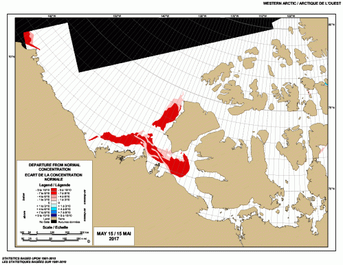
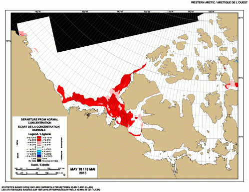
Weekly “departure from normal” for 2015 at 18 May (CIS) below, much more extensive than 2017 (above):
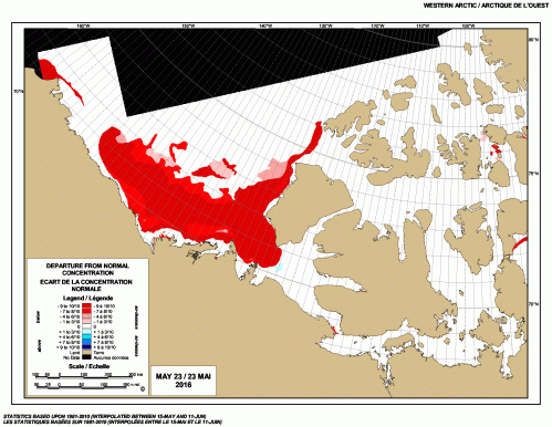
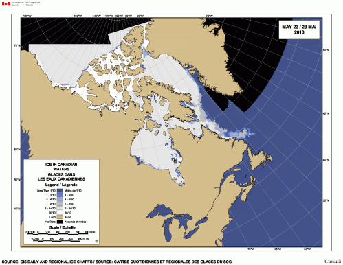
Weekly “departure from normal” for 2016 at 23 May (CIS) below, a week later than the maps above (previous week unavailable, but see ice maps below for 20 May 2016):
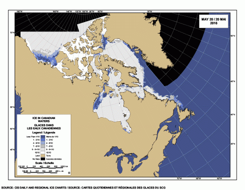
Here is what the same-date open water actually looks like on the standard CIS sea ice map, same order as above (2017, 2015, 2016), where bright white is solid pack ice:
20 May 2017

20 May 2015

20 May 2016
At 17 May 2014, there was no open water in the SB and but only small patches of thick pack ice (bright white along the Alaska shoreline):

At 17 May 2013 (the last one in my archive), shows a bit of open water in the SB and into the Northern Beaufort (along the coast of Banks Island and north) just beyond the bright white thick pack ice — probably a boon for local seals and bears:
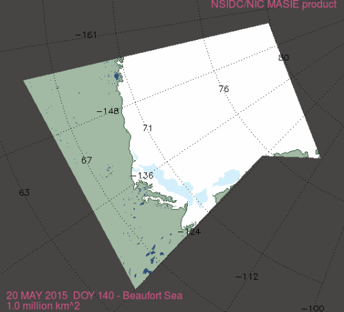
Another perspective is offered by sea ice maps generated by NSIDC’s MASIE, which offers the most comprehensive analysis of sea ice available.
Here is the MASIE map for the Beaufort Sea at 20 May 2011, for example:

And the MASIE map for the Beaufort Sea at 20 May 2015:
Compare the above to the MASIE map for the Beaufort Sea at 20 May 2016:

Compared to the above maps, the MASIE map for the Beaufort Sea at 20 May 2017 is much more like 2011 and 2015 than 2016 (in other words, not any kind of extreme):

References
Citta, J.J., Quakenbush, L.T., Okkonen, S.R., Druckenmiller, M.L., Maslowski, W., Clement-Kinney, J., George, J.C., Brower, H., Small, R.J., Ashjiang, C.J., Harwood, L.A., and Heide-Jørgensen, M.P. 2015. Ecological characteristics of core-use areas used by Bering–Chukchi–Beaufort (BCB) bowhead whales, 2006–2012. Progress in Oceanography 136:201–222. https://doi.org/10.1016/j.pocean.2014.08.012 Open access.
Crawford, J.A., Quakenbush, L.T. and Citta, J.J. 2015. A comparison of ringed and bearded seal diet, condition and productivity between historical (1975–1984) and recent (2003–2012) periods in the Alaskan Bering and Chukchi seas. Progress in Oceanography 136:133–150.
Harwood, L.A., Smith, T.G., George, J.C., Sandstrom, S.J., Walkusz, W. and Divoky, G.J. 2015. Change in the Beaufort Sea ecosystem: Diverging trends in body condition and/or production in five marine vertebrate species. Progress in Oceanography 136:263–273.
Stirling, I, Cleator, H. and Smith, T.G. 1981. Marine mammals. In: Polynyas in the Canadian Arctic, Stirling, I. and Cleator, H. (eds), pg. 45-58. Canadian Wildlife Service, Occasional Paper No. 45. Ottawa. Pdf of excerpt of above paper here.


You must be logged in to post a comment.