Tag Archives: western hudson bay

Breakup date average for W. Hudson Bay is July 1 – this year, it’s late again

In the last few days, ice coverage on Western Hudson Bay finally dropped below the 30% level that now defines ‘breakup’ for polar bears: a few bears near Churchill started to come ashore late last week but most will stay on the ice until the end of July. That means breakup this year was unofficially July 8th, a week later than average (July 1) for the third year in a row.
Sea ice extent Canada 2014 July 7 CIS

Don’t’ tell that to the folks at Polar Bears International, though, because they’re busy telling people that the ice-free season for Western Hudson Bay bears is now longer than it was before the 1990s. What they mean is that the overall trend is toward early breakup dates.

But what they don’t admit is that over the last 44 years, breakup was a full two weeks earlier than average for Western Hudson Bay only six times and only three of those early breakups occurred within the last 13 years. See the calculations below and see what you think.

Continue reading

Are Polar Bears Really Endangered?

Christina Wu at the Urban Times (July 3, 2014) recently asked this question. She came up with a surprisingly balanced argument but some predictable responses from IUCN Polar Bear Specialist Group (PBSG) biologists. As a consequence, she overlooked some critical facts that make a big difference to the answer.

Figure 1. Are polar bears really endangered? The US Fish and Wildlife Service thinks so, but only because Steven Amstrup, based on a computer model projecting sea ice out to 2050, said so (Amstrup et al. 2007). This information has been used by the Center for Biological Diversity and other NGOs, like WWF and Polar Bears International (where Amstrup is now employed), to solicit donations.

Figure 1. Predictions of polar bear population declines by 2050 are being used by the Center for Biological Diversity, WWF and Polar Bears International to solicit donations.

UPDATED 18 May 2015 – see below.

Continue reading

How long have polar bears – and people – lived around Hudson Bay?

I came across a story in the news yesterday about the discovery of an archaeological site in northeastern Manitoba that brings to mind a post I wrote back in November 2012 on the geological and archaeological history of Hudson Bay.

As I noted then, most of the archaeological sites found on or near the coast of Hudson Bay are about 1,000 years old or less – and this new site fits that pattern perfectly.

Hubbard Point Location Map with summer core area v1

A news report at the CBC (June 30, 2014) carried this description of the find, at a site called Hubbard Point, which sounds like it could yield polar bear remains: Continue reading

Spring/summer sea ice bonanza for polar bears – conditions excellent again for 2014

Again this year – contrary to predictions – there has been no early breakup of the sea ice on Hudson Bay and even though it’s the height of summer, there is plenty of ice throughout the Arctic to act as a feeding platform for polar bears. This makes it unlikely there will be a longer-than-average summer fast for polar bears again this year.

Figure 1. NSIDC MASIE map for June 21, 2014.

Figure 1. NSIDC MASIE map for June 21, 2014.

Sea ice maps around the Arctic for June 21 (and June 24, for Hudson Bay) reviewed and discussed below in relation to polar bear habitat — have a look.

Continue reading

Guest Post: Invasive Research is Alive and Well in Canada

This is a guest post by Kelsey Eliasson, who blogs at Polarbearalley, with his thoughts on the issue of the invasive research involved in polar bear mark-recapture studies around Churchill, Manitoba — which, as you’ll see, is a far different situation than I described for Nunavut (previous posts here, here, and here on this topic. Map below to get you oriented).

Kelsey is a writer, artist and polar bear guide who has spent 14 bear seasons watching the polar bears of Churchill. For five years, he ran Churchill’s monthly newspaper published occasionally, the Hudson Bay Post. Currently, he divides his year between the Yukon, Churchill and, occasionally, Riverton, home of Manitoba’s largest moose statue.

Churchill is in the Western Hudson Bay polar bear subpopulation, governed by the Province of Manitoba, while the community of Arviat, also in 'Western Hudson Bay' is overseen by the Government of Nunavut.

Churchill lies in the Western Hudson Bay (WHB) polar bear subpopulation, governed by the Province of Manitoba, while the community of Arviat, also in the Western Hudson Bay subpopulation, is overseen by the Government of Nunavut – different governments, different rules – as Kelsey points out below.

—————————————————————————-
Invasive Research is Alive and Well in Canada, by Kelsey Eliasson

The recent post about Foxe Basin was of particular interest to me, as I have been following the growing gap between the north and science for some time now. The stance taken by the Inuit is viewed as an inspiration by the guides over here in Churchill. For many years, we have tried to voice our deep concerns over the levels of handling and drugging that our bears (the Western Hudson Bay population) are subjected to on an annual basis.

This time last year, I tried to raise the topic for discussion after Andrew Derocher announced that ‘everything was on the table’ including feeding bears. At that time, the top polar bear researchers had sat down to discuss options for saving bears – except reducing handling and research – i.e. chasing bears down by helicopter and then shooting them with tranquilizers. Continue reading

Polar bear female with cubs fights off adult male – photos from W Hudson Bay

Discovery News ran a photo feature yesterday (January 28, 2014), courtesy Mike Lockhart from Polar Bears International, of an interesting incident Lockhart witnessed while was working with a government (Manitoba Conservation) research team surveying bears of Western Hudson Bay in the fall of 2013.

Figure 1. Female with 2 cubs turns on an adult male (far right) that she had been happily feeding with moments before. Mike Lockhart photo, Polar Bears International and Discovery News.

Figure 1. Female with 2 cubs turns on an adult male (far left) that she had been happily feeding with moments before. This is the 3rd photo in the sequence; see description and photo 4 below. Mike Lockhart photo, Polar Bears International, Discovery News story.

Continue reading

Churchill polar bears eat more caribou and geese now than in 1968 because there are more caribou and geese, new research reveals

The press release (pdf here) issued by the American Museum of Natural History (AMNH) a few days ago, regarding several recent papers on polar bear consumption of terrestrial foods around Churchill, Manitoba (Western Hudson Bay), left a lot to be desired in terms of relaying accurate information.

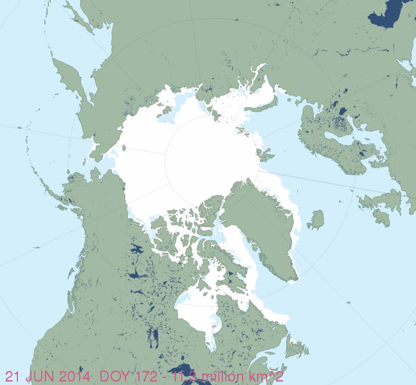
21 August 2021 UPDATE: I have amended this post to correct some comments I made originally about the definition of ‘spring breakup’ of sea ice on Hudson Bay. While the ice indeed begins to break up in spring (usually defined for the Arctic as April-June, bears rarely come ashore before July 1 (summer being July-September). Confusion comes from the standard meteorological method of the defining ‘breakup’ for Western Hudson Bay as the date when ice coverage drops below 50% of the area, rather than the newer, more relevant date when most polar bears have actually come ashore after the date ice coverage reaches 30% (Castro de la Guardia et al. 2017). Using the modern method, the earliest breakup date was in 1999 (17 June), which was still the case in 2021).

Recent research on polar bear diets by Robert Rockwell and Linda Gormezano, it says, suggests that an increase in the consumption of caribou and snow geese since 1968 is a sign that the polar bears are nutritionally stressed due to recent sea ice changes in spring (blamed on global warming) but may be adapting by changing their summer/fall diet.

As the AMNH press release puts it:

polar bears in the warming Arctic are turning to alternate food sources.”

Figure 1. Polar bear feeding on a caribou carcass, taken July 26, 2010. This photo was included in one of the papers cited in the January 2014 press release (Gormezano and Rockwell 2013:3518) and was clearly taken from the air. The caption in the paper says simply, “a polar bear looks up from the recently killed caribou it was eating,” so the bear may not have killed the caribou – some other predator (wolf or grizzly) may have made the actual kill. The dark spots on the bear appear to be flies. Credit Copyright American Museum of Natural History/ R. Rockwell.

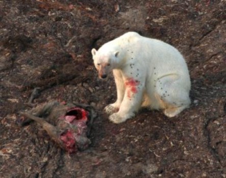
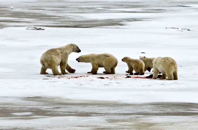
Figure 1. Polar bear feeding on a caribou carcass, taken July 26, 2010, from the air. This photo was included in virtually all media reports and in Gormezano and Rockwell (2013a:3518, Fig. 3). The caption in the paper says, “a polar bear looks up from the recently killed caribou it was eating,” implying the bear may not have actually killed the caribou – some other predator (wolf or grizzly) may have made the kill. The dark spots on the bear appear to be flies. Credit: Copyright American Museum of Natural History/R. Rockwell.

However, the AMNH press release fails to mention – as the papers it publicizes certainly do – that Western Hudson Bay populations of caribou and snow geese have increased exponentially since a similar polar bear diet study was done in 1968/69. In other words, there were hardly any caribou or geese around back in the late 60s — little wonder polar bears weren’t eating any.

While evidence of polar bears consuming caribou and geese in recent years is certainly an “increase” over late 1960s levels, that fact says more about the status of caribou and geese populations than it does about polar bears and global warming. Media outlets that quoted the press release verbatim, as many do these days (e.g. here, here, and here), missed this essential part of the story – and of course, so did their readers.

[one story picked up the goose population increase and another revealed the caribou population increase, but none that I saw caught both]

In addition, the AMNH press release makes this erroneous statement that was picked up by every media outlet I saw except one (either exactly as written or reworded slightly):

Climate warming is reducing the availability of their ice habitat, especially in the spring when polar bears gain most of their annual fat reserves by consuming seal pups before coming ashore for the summer.” [my bold]

The earliest breakup dates since 1991 for Western Hudson Bay, where this research was done, have been mid-June (according to the most recent study by Cherry et al. 2013) and for the last few years breakup has occurred in July.

Overall, the press release and resulting media reports seem to be further examples of hyping global warming at the expense of the actual science involved and I have to agree with Andrew Derocher’s interpretation of the significance of terrestrial food items for polar bears. See what you think.
Continue reading

The scientific abomination that is the “Circumpolar Monitoring Framework for Polar Bears”

I keep coming across mentions of a grandiose plan for future polar bear research and conservation called the “Circumpolar Monitoring Framework for Polar Bears.”

This “framework” plan was referred to extensively at the recent International Polar Bear Forum (aka the “Meeting of the Parties” that signed the 1973 conservation treaty) held in Moscow, December 3-6, 2013 (see posts about the meeting here, here, and here). In fact, government representatives of all Arctic nations present at that meeting agreed in principle to support the proposed plan.

No media reports that I’ve come across after the Moscow polar bear meeting explained what the “monitoring framework” involved, so I’ve composed a brief summary and commentary, aided by some images from Dag Vongraven’s presentation in Moscow (Vongraven 2013; pdf here).

In short, Arctic government representatives at the Moscow forum agreed that all future polar bear research should be constrained by the premise that increases in global temperatures over the next century will occur exactly as predicted by climate models and will negatively affect polar bears precisely as predicted by models devised by polar bear biologists. Under the plan, subpopulations that are already showing predicted effects of global warming will get the bulk of research funds, while regions that are paradoxically not responding as predicted will get much less money for research and survey efforts. 

This strategy proposes a coordinated research plan that is blatantly agenda-driven: implementing it would seriously compromise the usefulness of all research results generated for decades to come. I don’t think it’s anything close to being a scientifically valid plan, but decide for yourself. 

Figure 1. Vongraven 2013, Slide 1.

Figure 1. Vongraven 2013, Title slide.

Continue reading

Another unsupported claim of starving polar bears in Western Hudson Bay

This time it was Steven Amstrup of Polar Bears International (PBI), via a radio interview on Saturday December 28 “A Scientist’s New Job: Keeping The Polar Bears’ Plight Public.

Amstrup – co-author of the models that predict the extinction of polar bears by the end of this century – had this to say about the polar bear situation in Hudson Bay:

This year, the ice was frozen longer, so he says the bears seem to be in pretty good shape.

“But over the last two or three years, my impression has been, ‘Man, there’s a lot of skinny bears out here.’ “

On average, the sea ice in the Hudson Bay is frozen about a month less per year than it was 30 years ago. Amstrup says bears don’t eat much on land, so they lose about 2 pounds of body fat every day they’re off the ice.

“They’re 60 pounds lighter now than they might have been at this time of year 30 years ago,” he says.” [my bold]

For the last two or three years Amstrup has been seeing “a lot of skinny bears” but hasn’t taken a single photograph that he’s offered for publication or posted at PBI? Makes you wonder, doesn’t it – where are the photos of all the starving bears these guys keep talking about?

Here is a picture of a polar bear that was spending the summer on the shore of Western Hudson Bay 30 years ago, taken in July [bears were on the shore in July this year as well]. Continue reading

Polar bear habitat update, end of November 2013

Freeze-up in the Arctic (~October-November) is important to polar bears because for those animals that have spent the ice-free period on shore (not all do), it marks the end of their summer fast — they can finally resume seal hunting.

Polar bears in the most southern regions, like Southern Hudson Bay, Western Hudson Bay, and Davis Strait (see Fig. 1), routinely experience the longest ice-free period. As these bears all spend the summer on shore, they appreciate a timely return of the ice.

 Figure 1. Polar bear subpopulations defined by the IUCN Polar Bear Specialist Group (PBSG), with a few extra labels added. I’ve rotated the original map 90 degrees (right) to make it easier to relate to the ice maps below. WH is Western Hudson Bay. Courtesy PBSG.  Click to enlarge.


Figure 1. Polar bear subpopulations defined by the IUCN Polar Bear Specialist Group (PBSG), with a few extra labels added. I’ve rotated the original map 90 degrees (right) to make it easier to relate to the ice maps below. WH is Western Hudson Bay; SB is Southern Beaufort. Courtesy PBSG. Click to enlarge.

Southern Hudson Bay bear populations routinely experience an ice-free season that is just as long as it is for Western Hudson Bay bears. However, Southern Hudson Bay polar bears numbers have remained stable over the last 30 years. Some folks insist that Western Hudson Bay bear numbers are shrinking to a worrisome degree, despite indications that the recent decline could be nothing more than a return to sustainable levels after a rapid population increase in the late 20th century (similar to changes documented for the Davis Strait and Barents Sea subpopulations).

Have a look at how sea ice – essential polar bear hunting habitat – has developed within these regions over the last 10 days or so (end of November 2013) and how November 2013 compares to November 1979. The ice maps tell the freeze-up story.
Continue reading