Tag Archives: James Bay

Western Hudson Bay freeze-up earlier than average for 1980s for the third year in a row

This is the third year in a row that freeze-up of Western Hudson Bay (WH) ice has come earlier than the average of 16 November documented in the 1980s. Reports by folks on the ground near Churchill confirm polar bears are starting to move onto the sea ice that’s developing along the shore after almost 5 months on land. After five good sea ice seasons in a row for WH polar bears, this repeat of an early freeze-up means a sixth good ice season is now possible for 2019-2020.

Sadly for the tourists, however, it means the polar bear viewing season in Churchill will be ending early this year, just like it did last year and the year before.

Churchill pbs checking the ice 10 Nov 2019 Amanda Atarling photo

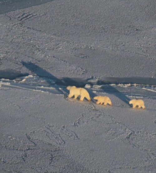
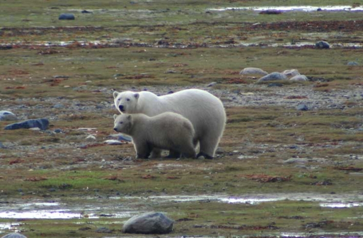
Polar bear family on the ice off Churchill Manitoba (taken from a helicopter), courtesy Explore.org

When mothers with cubs are out on the ice (see photo above), it’s pretty certain the mass movement from land to sea ice is well underway because these family units are usually the last to leave.

UPDATE 19 November 2019: Polar Bear Alert report for 11-17 Nov (week 20) confirms that freeze-up is underway, bears are heading out on the ice and problem bears held in the ‘jail’ were released 13 November. See below.
Continue reading

Davis Strait polar bear habitat well above average for the first week of winter

The region inhabited by the Davis Strait subpopulation of polar bears dips as far south as James Bay and has a history of highly variable sea ice coverage.

Canadian Arctic Jan 7 2016_CIS

For the last two years Davis Strait sea ice in March has been well above average, while other years it been well below. You might be surprised to hear that 1969 had the lowest February/March ice coverage over the entire the 1969-2002 record (Johnston et al. 2005: 211), which ice charts show now extend to 2015 (see below). Reports of sealers working north of Newfoundland and in the Gulf of St. Lawrence in the first few decades of the 20th century show this variability has likely always been a characteristic of the area (Ryan 2014).

Remarkably, this year’s ice coverage for the first week in January is well above what they were in 2014 and 2015 – even though those two years were above average by March. In fact, there hasn’t been this much polar bear habitat in the Southern Labrador Sea in the first week of January since at least 1993.
Continue reading

Some polar bears make poor choices, like this one in James Bay

CBC reported this morning that a polar bear was shot last Friday (18 December) at the dump in Moose Factory, Ontario – long past the date when bears in Southern Hudson Bay are usually out on the ice. But a single bear in trouble does not spell catastrophe for the species or the local population: how many times does this need to be said?

Moose Factory_Wikipedia

Claims of “almost no ice” seem a bit disingenuous, since this seems to be the only bear caught in this situation (if there are others, no one has reported it): other bears appear to have either made use of the ice that was present (see map below) or walked north until they found more ice. This bear (picture below) seems to have decided that the fare on land might do for a while longer, which suggests he’s either a subadult bear (with little experience) or an old one – looks like the former to me in the picture below but the report doesn’t say.

Moose Factory_polar-bear-in-dump_CBC Dec 22 2015

Continue reading

Researcher says most S. Hudson Bay polar bears still on the ice, may have to swim home

More than half of Southern Hudson Bay polar bears under study are still out on the thick Hudson Bay sea ice that’s been giving Canadian Coast Guard icebreakers so much trouble.

Figure 6. James Bay polar bear female and her cub during the ice-free period. Notice how fat they both are. Courtesy Ministry of Natural Resources, News Ontario, June 2, 2009.

James Bay polar bear female and her cub on shore. Courtesy Ministry of Natural Resources, News Ontario, June 2, 2009.

As I pointed out a few days ago, most of the ice remaining on Hudson Bay is in the region used by Southern Hudson Bay polar bears. While you wouldn’t know it from the Polar Bears International “Bear Tracker” – which hasn’t been updated since 2 July – on Friday (24 July 2015) Ontario polar bear researcher Martyn Obbard used the PBI website to reveal where his study sample of polar bears are located.

Obbard posted a little essay on PBI’s “Save our sea ice!” website which had, buried near the end, the admission that on 20 July, five out of his nine Southern Hudson Bay females with satellite radio collars were still out on the ice, “far from the Ontario coast.
Continue reading

Polar bear habitat virtually everywhere now

What did I tell you, back in mid-September?

Have a look at all the polar bear habit, ten days shy of the end of November!

Figure 1. MASIE sea ice extent for November 18, 2013 (using US National Ice Center data). You have to look closely but there is indeed ice forming around Svalbard (just above the tip of Greenland) and in James Bay (southern Hudson Bay). Click to enlarge. High resolution map here.

Figure 1. MASIE sea ice extent for November 18, 2013 (using US National Ice Center data). You have to look closely but there is indeed ice forming around Svalbard (just above the tip of Greenland) and in James Bay (southern Hudson Bay). Click to enlarge. High resolution map here.

Figure 2. Canadian Ice Service map. Good amounts of ice developing in northern Hudson Bay, Foxe Basin and Davis Strait (between southern Greenland and Baffin Island), with ice forming along the shore in James Bay (the southern-most region where polar bears are on-shore at the moment). Click to enlarge.

Figure 2. Canadian Ice Service map. Ice developing rapidly in northern Hudson Bay, Foxe Basin and Davis Strait (between southern Greenland and Baffin Island), with ice also forming along the shore in James Bay (the southern-most region where polar bears are onshore at the moment). Click to enlarge.

Southern Hudson Bay subpopulation status, farthest south of all polar bears

“The Arctic” is a bit hard to define. While the Arctic Circle works as a good boundary for some purposes and the 100C isotherm for July for others, neither work for polar bears because several subpopulations live well south of these limits (Fig. 1).

In the east, Western Hudson Bay, Southern Hudson Bay and Davis Strait are all located well south of the Arctic Circle and the first two (and half of Davis Strait) are beyond the 100C July isotherm as well. In the western Arctic, the Chukchi Sea subpopulation is within the 100C July isotherm but at least half of its bears reside south of the Arctic Circle (Fig. 1) in the Bering Sea (see previous post here).

Unique amongst all of these is Southern Hudson Bay – all of its polar bears make maternity dens and/or spend the summer south of 600N.

Southern Hudson Bay (SH) bears live in the Canadian provinces of Ontario, while Western Hudson Bay (WH) bears reside in Manitoba and Nunavut. The two groups mix over the winter but appear to spend the summer/fall in their respective regions (Stirling et al. 2004). [See previous posts on Western Hudson Bay bears here, here, and here]

“Further south” in the Arctic usually means warmer, with open water present more weeks every summer, sea ice for fewer weeks over the winter. So, shouldn’t the bears of Southern Hudson Bay be already suffering more harm from global warming than virtually all other subpopulations, including those in Western Hudson Bay?

After all, Western Hudson Bay bears appear to have experienced a statistically significant decline in numbers, among other effects (Regehr et al. 2007; Stirling and Derocher 2012) — surely Southern Hudson Bay bears are doing worse?

You’d think so, but they aren’t.

Figure 1. Boundary limits for “the Arctic” (top map) such as the Arctic Circle (dashed line) or the 100C isotherm for July (solid red line) would not include several polar bear subpopulations that live south of these.

Figure 1. Boundary limits for “the Arctic” (top map) such as the Arctic Circle (dashed line) or the 100C isotherm for July (solid red line) would not include several polar bear subpopulations that live south of these.

UPDATED October 28, 2014: Reference added, Obbard et al. 2013 (aerial survey results).
Continue reading