Tag Archives: polar bear status

Twenty good reasons not to worry about polar bears

PB  logo coloured Here’s a new resource for cooling the polar bear spin, all in one place. I’ve updated and expanded my previous summary of reasons not to worry about polar bears, which is now two years old. In it, you’ll find links to supporting information (including previous blog posts of mine that provide background, maps and extensive references), although some of the most important graphs and maps have been copied into the summary. I hope you find it a useful resource for refuting the spin and tuning out the cries of doom and gloom about the future of polar bears — please feel free to share. Pdf here of the text below.

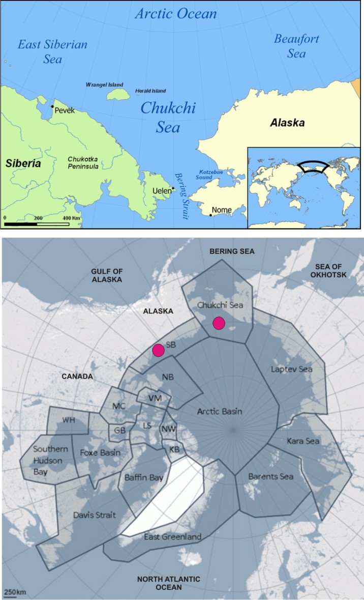
This is the 1st anniversary of Canada providing population estimates and trends independent of the pessimistic prognostications of the IUCN/SSC Polar Bear Specialist Group (PBSG) — so let’s celebrate the recent triumphs and resilience of polar bears to their ever-changing Arctic environment.

AK PB N Shore-USFWS Barrow_labeled
Continue reading

Davis Strait polar bear habitat higher now than in 1979 and early 1980s

The Davis Strait polar bear subpopulation is said to be ‘vulnerable’ to the supposed effects of global warming because, like Hudson Bay, Davis Strait sea ice retreats every summer, leaving polar bears on land for several months.

However, Davis Strait bears have been upgraded to ‘stable’ status, according to the latest table (2013) issued by the IUCN Polar Bear Specialist Group (see their boundary map for Davis Strait bears below). Recent development of sea ice in the region can only improve that rating.

[More background here and heremap-DavisStrait

It seems that sea ice in Davis Strait is well above normal for this time of year – a recent announcement by the Canadian Ice Service (CIS) says it’s 10% above average, higher than it’s been in 25 years (h/t S. Goddard).

The Canadian Ice Service, an arm of Environment Canada, said there is 10 per cent more ice this year compared to the 30-year average.

We probably haven’t seen a winter this bad as far as ice for the past 25 years,” said Voight, referring to both the amount and thickness of the ice.

He said the Gulf of St. Lawrence is covered and some areas are “quite severe.” [my bold]

Full story here.

Latest ice map (March 12) below from the US National Snow and Ice Data Service (NSIDC).

As I pointed out recently here, Barents Sea ice is below average this year, largely due to natural variation in the Atlantic Multidecal Oscillation (AMO), but is higher over the western Atlantic (Sea of Okhotsk ice is below average too but there are no polar bears there).

There is lots of ice around Labrador and Newfoundland, however.

Sea ice extent 2014 March 12 NSIDC

I thought I let you see exactly what CIS are talking about: what did the ice look like 25 years ago, in 1989? What about 35 years ago, in 1979, the start of the satellite record for sea ice? It might surprise you. Continue reading

Chukchi-Beaufort ice extent comparison – why feature only the last 7 years?

The most recent issue of Arctic Sea Ice News provided by the National Snow and Ice Data Center (NSIDC) – the official US keeper of sea ice data – (July 17, 2013) included an interesting graph of sea ice extent in the Chukchi and Beaufort Seas at July 12.

They present the data for 2007 to 2013, compared to the new 30 year average1, and note that the Beaufort Sea had “the most extensive ice cover seen there in the last seven summers.” It is also clear from their graph that the 2013 extent was virtually identical to the average in both regions (Fig. 1).

Figure 1. Graph of sea ice extent at July 12 each year from 2007 to 2013 from the National Snow and Ice Data Center, NSIDC. “Climatology” (last set of bars) is the 30 year average (1981-2010) extent at this date.1 In 2013, the Beaufort Sea had “the most extensive ice cover seen there in the last seven summers” (NSIDC). It is also clear from the graph that the 2013 extent was virtually identical to the 30-year average. Map from Wikipedia. Click to enlarge.

Figure 1. Graph of sea ice extent at July 12 each year from 2007 to 2013 from the National Snow and Ice Data Center, NSIDC. “Climatology” (last set of bars) is the 30 year average (1981-2010) extent at this date.1 It is clear from the graph that the 2013 extent was virtually identical to the 30-year average. Map from Wikipedia.

What puzzled me was why they featured only the last 7 years when satellite data go back to at least 1979. Is there something in that data they don’t want us to see?

There is no similar data in graph form available that I could find but there is the wonderful comparative sea ice mapping tool provided by Cryosphere Today, operated by the University of Illinois.

So, in the absence of numerical data to compare to the Fig. 1 graph, I chose visual data to ask the question: what could there be about the long-term record of Chukchi/Beaufort sea ice data that the NSIDC might not want us to know?

The ice coverage at mid-summer (July 12) provides a snapshot of what sea ice  conditions are like for polar bears before the summer melt season gets into full swing, so this historical perspective is quite revealing. [See previous posts here, here, and here for more on Chukchi/Beaufort polar bears.]
Continue reading

Chukchi polar bear status contradicts the “message” – new details

Previously, I summarized preliminary results of polar bear research in the Chukchi Sea undertaken between 2008 and 2011 by US Fish & Wildlife biologist Eric Regehr and US Geological Survey researcher Karyn Rode. At the time, a peer-reviewed paper on this study was promised shortly.

It now appears this paper is indeed on the way. I’m sure of that because a few weeks ago, I came across a conference presentation given by Karyn Rode that is a summary of the upcoming Chukchi research paper. The title of both presentation and ‘in review’ paper is:

“Variation in the response of an Arctic top predator experiencing habitat loss: feeding and reproductive ecology of two polar bear populations.

Rode’s slide presentation (given at the annual Lowell Wakefield Fisheries Symposium at the end of March, in Anchorage, Alaska) was posted online by the symposium organizers. It provides some very interesting details on the status of Chukchi Sea bears compared to bears in the Southern Beaufort, and contains some mighty “inconvenient” conclusions that should raise some eyebrows.

I’ve summarized these details and conclusions below in point form, below the maps.

Figure 1. Chukchi and Beaufort Seas (from Wikipedia), upper. ‘Chukchi Sea’ polar bears are shared between the USA and Russia; ‘Southern Beaufort’ bears are shared between the US and Canada, lower (from PBSG, with labels added). Pink dots are the subpopulations featured in the Rode et al. presentation and upcoming paper.

Figure 1. Chukchi and Beaufort Seas (from Wikipedia), upper. ‘Chukchi Sea’ polar bears are shared between the USA and Russia; ‘Southern Beaufort’ bears are shared between the US and Canada, lower (from PBSG, with labels added). Pink dots are the subpopulations featured in the Rode et al. presentation and upcoming paper.

Continue reading