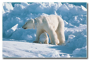
All three polar bear females tagged in the Southern Beaufort Sea far west of Kaktovik (near Barrow) spent all or most of September onshore in the Northern Beaufort area of Canada.
![]()

All three polar bear females tagged in the Southern Beaufort Sea far west of Kaktovik (near Barrow) spent all or most of September onshore in the Northern Beaufort area of Canada.
![]()
Comments Off on Tracking Western Alaskan polar bears in the Beaufort in Sept – all 3 chose Canada
Posted in Life History, Sea ice habitat
Tagged Banks Island, Barrow, Beaufort Sea, boundaries, Kaktovik, mixing, polar bear, satellite radio collars, sea ice, subpopulations, tracking polar bears, USGS, Western Arctic
The recent open water in the Southern Beaufort didn’t seem to change what polar bears were doing – bears tracked by USGS show them on the ice, likely trying to hunt. More ice edge means more hunting habitat at this time of year.
![]()
However, few hunts are likely successful at this time of year – because only older seals are on the ice and the broken ice makes escape so much easier for the seals (see previous post here). Fat bears on shore this summer (like the ones seen at Kaktovik in September) will tell us that they got enough to eat earlier in the season. Note that bears in good condition that appear at the whaling bone piles in September are there by choice (not stranding) and they got fat by feeding in the spring (March-May), not by picking at leftover whale scraps. Calories from terrestrial sources (for most bears) just reduce the amount of weight they lose over the summer.
More maps below. Continue reading
Comments Off on Tracking polar bears in the Beaufort Sea – all bears on the ice in June
Posted in Life History, Sea ice habitat
Tagged Beaufort Sea, fat bears, feeding, satellite radio collars, sea ice, spring feeding, summer fast, tracking polar bears, USGS
Five more bears were tagged near the Southern Beaufort Sea coast last month, all in the western portion of the coast where Chukchi Sea bears are often encountered. They join the one female who seems to have made a den way out over the continental shelf, where she’s been all winter.
This is the March 2016 follow-up to my post on the July 2013 track map for female polar bears being followed by satellite in the Beaufort Sea by the US Geological Survey (USGS) – “Ten out of ten polar bears being tracked this summer in the Beaufort Sea are on the ice.”
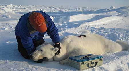
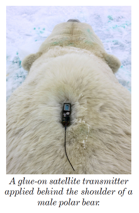
Five tagged bears are relatively few compared to eight last spring, and thirteen in 2013 [added to 7 from the previous year for a total of twenty, which were down to 13 by June] but the same as five tagged in 2014. This spring, three of the USGS tagged bears have glue-on transmitters, which means they are either males or juvenile bears rather than females (which are fitted with collars):
“In collaboration with the U.S. Fish and Wildlife Service we are also experimenting with glue-on and ear tag satellite transmitters, which can be deployed on adult male bears and younger, still-growing bears.”
Comments Off on Tracking polar bears in the Beaufort Sea – new crop of tagged bears for 2016
Posted in Life History, Sea ice habitat
Tagged Barrow, Beaufort Sea, glue-on transmitters, ice thickness, sea ice, tagging, thick spring ice, tracking polar bears, USGS
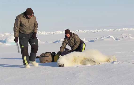
All three of the females with radio collars installed by USGS last spring (see footnote below) spent October out on the sea ice – which suggests the Kaktovik female with the tight collar that made the news last week was either wearing a failed collar, USGS removed her icon from the map, or she was not wearing a USGS collar.

It is possible that the poor bear was the one represented by the purple icon from last month (see map below), the only USGS collared bear that was on shore during September and still sending signals. The bear in the above photo was photographed in Kaktovik, easy walking distance for a bear, near the end of October. The purple icon on shore in the September USGS map is no longer present this month.
As far as I know, there has been no follow-up information on the fate of this bear: we still don’t know whether the collar has yet been successfully removed.
Continue reading
Comments Off on Tracking polar bears in the Beaufort Sea – all three bears on the ice during October 2015
Posted in Life History, Sea ice habitat
Tagged Arctic, Beaufort Sea, satellite collars, sea ice, tight collar, tracking polar bears, USGS
Despite the public outcry last week over future polar bear survival, the polar-bears-are-doomed crowd can’t hide the fact that this year, spring sea ice habitat for polar bears worldwide has been excellent.
This year on 19 July, for example, Hudson Bay had greater than 150,000 square km more sea ice than there was in 2009 on that date (526.2 vs. 368.5 mkm2)(1992 was a particularly cold year and most bears left the ice as late in 2009 as they did in 1992).1 Conditions have also been excellent for pregnant females around Svalbard – Norwegian polar bear researchers recently reported a good crop of cubs this spring.
Worldwide, there was exactly the same amount of Arctic sea ice present on 18 July 2015 as there was back in 2006 (Day 199) – 8.4 mkm2. By 19 July (day 200), 2015 had more ice than 2006 (8.4 mkm2 vs. 8.3).
All this means that recent summer ice melt has not impinged on the spring feeding period that is so critically important for polar bears. So much ice left in early summer means there was lots of sea ice in the spring (April-June), even in the Southern Beaufort Sea.
The only region with sea ice coverage well below the last five years is the Chukchi Sea (see plots below, click to enlarge). So why aren’t we hearing the-sky-is-falling stories about Chukchi bears? Because biologist have already demonstrated that polar bears in the Chukchi do very well even with no summer sea ice.
Continue reading
Comments Off on Alarm over future summer polar bear habitat disguises how good conditions are right now
Posted in Life History, Sea ice habitat
Tagged Chukchi Sea, Derocher, habitat, Hudson Bay, melt ponds, polar bear, polar bear science, sea ice, Southern Beaufort, spring ice conditions, summer sea ice, Svalbard, thick spring ice, tracking polar bears, walking hibernation
USGS biologists were clearly busy this spring putting more satellite radio collars and glue-on tags on Southern Beaufort Sea polar bears but there’s some surprising information in their April 2015 tracking map about current sea ice conditions.
From the 2013-2014 issue of “Polar Bear News” (USFWS).
What’s interesting is that the sea ice maps they use show less dark spots that might be open water this year than were present last year in late April. Oddly, this phenomenon has one prominent biologist worried about “challenging” polar bear habitat developing this year – without mentioning last year at all.
The USGS track map for April 2015 is copied below.1
Continue reading
Comments Off on Tracking polar bears in the Southern Beaufort, with a sea ice surprise – April 2015 map
Posted in Life History, Sea ice habitat
Tagged Beaufort Sea, Chukchi Sea, Eastern Beaufort, habitat, ice maps, melt ponds, polar bear movements, polar bears, satellite collars, satellite images, sea ice, Southern Beaufort, tracking polar bears, USGS
Here is the March 2015 follow-up to my post on the July 2013 track map for female polar bears being followed by satellite in the Beaufort Sea by the US Geological Survey (USGS) – “Ten out of ten polar bears being tracked this summer in the Beaufort Sea are on the ice.”

See that post for methods and other background on this topic, and some track maps from 2012 (also available at the USGS website here). The USGS track map for March 2015 is copied below.
Three out of eight female bears tagged in the Southern Beaufort Sea were in the Chukchi Sea subpopulation region during March – not surprising, many bears cross this “boundary.”
Continue reading
Comments Off on Tracking polar bears in the Beaufort Sea – March 2015 map
Posted in Life History, Sea ice habitat
Tagged Beaufort Sea, Chukchi Sea, polar bear habitat, polar bear movements, polar bears, satellite collars, sea ice, Southern Beaufort, spring, subpopulation boundaries, tracking polar bears, USGS
Here is the February 2015 follow-up to my post on the July 2013 track map for female polar bears being followed by satellite in the Beaufort Sea by the US Geological Survey (USGS) – “Ten out of ten polar bears being tracked this summer in the Beaufort Sea are on the ice.”
See that post for methods and other background on this topic, and some track maps from 2012 (also available at the USGS website here). The USGS track map for February 2015 is copied below.
There were 7 bears in February, up from 6 in January, because one of the bears has re-entered the area from elsewhere. However, many bears from the original sample have either had their collars fail, moved out of the area and stayed out, or they have died. We can’t tell from which of those options, or combinations of them, explain the reduced number still being followed.
Continue reading
Comments Off on Tracking polar bears in the Beaufort Sea – February 2015 map
Posted in Life History, Sea ice habitat
Tagged Beaufort Sea, Chukchi Sea, polar bear habitat, polar bear movements, polar bears, polar bears in winter, satellite collars, sea ice, Southern Beaufort, tracking polar bears, USGS
Here is the January 2015 follow-up to my post on the July 2013 track map for female polar bears being followed by satellite in the Beaufort Sea by the US Geological Survey (USGS) – “Ten out of ten polar bears being tracked this summer in the Beaufort Sea are on the ice.”
See that post for methods and other background on this topic, and some track maps from 2012 (also available at the USGS website here). The USGS track map for January is copied below.
There are only 6 bears being followed now, which means a few more collars have failed, or the bears have moved out of the area or died.
Continue reading
Comments Off on Tracking polar bears in the Beaufort Sea – January 2015 map
Posted in Life History, Sea ice habitat
Tagged Beaufort Sea, Chukchi Sea, polar bear habitat, polar bear movements, polar bears, polar bears in winter, satellite collars, sea ice, Southern Beaufort, tracking polar bears, USGS
Here is the December 2014 follow-up to my post on the July 2013 track map for female polar bears being followed by satellite in the Beaufort Sea by the US Geological Survey (USGS) – “Ten out of ten polar bears being tracked this summer in the Beaufort Sea are on the ice.”

See that post for methods and other background on this topic, and some track maps from 2012 (also available at the USGS website here). The USGS track map for December is copied below.
There are only 10 bears being followed now, which means a few more collars have failed, or the bears have moved out of the area or died.
Continue reading
Comments Off on Tracking polar bears in the Beaufort Sea – December 2014 map
Posted in Life History, Sea ice habitat
Tagged Beaufort Sea, Chukchi Sea, polar bear habitat, polar bear movements, polar bears, polar bears in winter, satellite collars, sea ice, Southern Beaufort, tracking polar bears, USGS


You must be logged in to post a comment.