Tag Archives: western hudson bay

Polar bear researchers still withholding Hudson Bay data

The latest polar bear propaganda emanating from The Guardian is unscientific nonsense fed to them by activist Canadian polar bear researchers: Polar bear numbers in Hudson Bay of Canada on verge of collapse.

This episode of Goldenberg’s polar bear grandstanding includes a photo caption with a totally unsubstantiated claim that some folks might call a lie:

Melting ice is cutting polar bears off from their food source in Hudson Bay, and death rates have soared.

“Death rates have soared”? Where are all the bodies? Show us the starving bears!

In fact, the ice of Hudson Bay melts every summer and always has done. When it does, polar bears go ashore and live off the many inches of stored blubber they put on during their spring feasting on fat baby seals. The last three years, the open-water season has been only about two weeks longer than it was in the 1980s. There has been no steady increase but lots of variability.

Below I dismantle the rest of this transparently political posturing ahead of the international polar bear forum next week.
Continue reading

Polar bear researchers – are they protecting the bears or their own jobs?

Poor polar bear researchers: there are few full time jobs worldwide and research is underfunded.

This is not my opinion but the facts according to Andrew Derocher and Ian Stirling (2011) — see Fig. 1 and 2 below. I do not dispute them.

Figure 1. The distribution of full-time polar bear researchers worldwide. Graduate students carry out much of the field work, funded by research grants – but eventually, they are going to want full-time jobs too. Where will the money come from? From Derocher and Stirling 2011. Slide 8 from “Conservation status, monitoring, and information gaps.” Invited speaker presentation to the 2011 Polar Bear Meeting in Nunavut, USA contingent. Oct 24-26, 2011.

Figure 1. The distribution of full-time polar bear researchers worldwide. From Derocher and Stirling 2011, invited speaker presentation to the 2011 Polar Bear Meeting in Nunavut, Oct 24-26.

Figure 2. The sad state of polar bear research. From Derocher and Stirling 2011. Slide from “Conservation status, monitoring, and information gaps.” Invited speaker presentation to the 2011 Polar Bear Meeting in Nunavut, USA contingent. Oct 24-26, 2011.

Figure 2. The sad state of polar bear research. From Derocher and Stirling 2011, Invited speaker presentation to the 2011 Polar Bear Meeting in Nunavut, Oct 24-26.

Since Derocher and Stirling have raised the issue, I contend it’s perfectly valid to ask: are polar bear biologists who proclaim their heartfelt fear for the future of polar bears at every opportunity behaving as advocates for polar bears or protecting their own careers?

Continue reading

Polar bear habitat virtually everywhere now

What did I tell you, back in mid-September?

Have a look at all the polar bear habit, ten days shy of the end of November!

Figure 1. MASIE sea ice extent for November 18, 2013 (using US National Ice Center data). You have to look closely but there is indeed ice forming around Svalbard (just above the tip of Greenland) and in James Bay (southern Hudson Bay). Click to enlarge. High resolution map here.

Figure 1. MASIE sea ice extent for November 18, 2013 (using US National Ice Center data). You have to look closely but there is indeed ice forming around Svalbard (just above the tip of Greenland) and in James Bay (southern Hudson Bay). Click to enlarge. High resolution map here.

Figure 2. Canadian Ice Service map. Good amounts of ice developing in northern Hudson Bay, Foxe Basin and Davis Strait (between southern Greenland and Baffin Island), with ice forming along the shore in James Bay (the southern-most region where polar bears are on-shore at the moment). Click to enlarge.

Figure 2. Canadian Ice Service map. Ice developing rapidly in northern Hudson Bay, Foxe Basin and Davis Strait (between southern Greenland and Baffin Island), with ice also forming along the shore in James Bay (the southern-most region where polar bears are onshore at the moment). Click to enlarge.

Amstrup compares climate change to a Titanic for polar bears

Steven Amstrup, spokesperson for Polar Bears International, has ramped up his “save the polar bear” rhetoric over last week’s nonsense.

Last night (November 13), the NBC News online story (here) that accompanied their evening news clip (h/t DB) included this appalling analogy:

“…Amstrup said greenhouse gases created by humans threaten future generations of bears by threatening their ice. He said he likes to compare climate change’s effect on polar bears to the infamous Titanic ocean liner.

“[It] didn’t matter how many people were on the Titanic or how well they were doing,” he said. “When the Titanic slipped beneath the waves and they lost their habitat, that was it. So polar bears will also go away because of their dependence on sea ice.” [my bold]

Amstrup really wants people to believe that all the polar bears in the world will die some day, all at once, in some mega ice-loss catastrophe!
Continue reading

Hudson Bay freeze-up average this year – not late

Freeze-up in Western Hudson Bay is finally underway. It’s no later this year than average, similar to last year.

This rather contradicts the hysterical hue and cry from the tag-team of Polar Bears International (PBI) spokesperson Steven Amstrup and Guardian reporter Suzanne Goldenberg last week during PBI’s “Polar Bear Week” propaganda blitz (see previous posts here, here, and here), 

So much for the trend towards later freeze-up dates that PBI says is endangering polar bears in Western Hudson Bay.

On-the-ground observers confirm polar bears are preparing to move out and sea ice maps show the ice is forming very rapidly — see maps and quotes below.

Continue reading

Challenging “save the polar bear” propaganda

[Updates: Note correction to point 6 and links added at the end of the post]

Polar Bears International has mustered the UK newspaper, The Guardian, to provide free publicity for a “save the polar bear” propaganda event coming up tomorrow, November 6.

From The Guardian Environment Blog:

“On Wednesday, 6 November at 10am EST and 3pm GMT you will have a chance to ask a scientist [Steven Amstrup] and a conservationist [Krista Wright] about the latest research on the state of polar bears – and the efforts to protect them.”

The “participants” of this webchat are Polar Bears International (PBI) employees. PBI is a lobbyist organization that uses its influence to pressure politicians and supposedly impartial scientific organizations, like the IUCN Polar Bear Specialist Group (PBSG), to make decisions that fit their agenda. The PBI rallying cry is “Save Our Sea Ice.They are committed to promoting legislation to curtail supposed effects of anthropogenic global warming and are using polar bears as a tool to do so.

Dr. Steve Amstrup is now a full-time, professional activist and spokesperson for PBI (Chief Scientist and Vice President”), a job he took on after a long career as a polar bear biologist. Arranging “webchats” like this is part of the job he is now paid to do.

Krista Wright has a Bachelors degree in Outdoor Education and has worked for NGOs for more than 20 years. She joined PBI in 2009 and is now the Executive Director (i.e., an administrator). She is described as “a passionate conservationist who is deeply concerned about the effects of global warming on polar bears, the Arctic, and the planet.She brings emotion to this event, not science.

Below I dissect some of the fear-mongering background presented at The Guardian, one point at a time; Guardian quotes are in italics, numbered; my responses are below, with links to pertinent previous posts that are fully referenced:

[Links to video and the webchat Q & A have been added at the end of this post as updates]

Continue reading

Churchill polar bear attack shamelessly used to advance global warming agenda

I guess Suzanne Goldenberg, writing for The Guardian, just couldn’t help herself with this latest story (November 4):Polar bear attacks: scientists warn of fresh dangers in warming Arctic. Two people injured in latest attack as hungry bears deprived of access to sea ice increasingly look for food on land.

Reporting on the attack is one thing — several papers covered this over the weekend (see Featured Quote #46, posted yesterday, for links to two of them). However, Goldenberg shamelessly makes this about global warming, aided and abetted by Polar Bears International (PBI) representative Steven Amstrup, a claim that doesn’t hold up to even minor scrutiny.

Continue reading

Kaktovik polar bears could be back on the ice this weekend

This is a quick follow up on my last post (here) on Kaktovik polar bears of the Southern Beaufort Sea subpopulation.

Kaktovik is the bright pink dot on the ice map below (October 3, 2013: click to enlarge), from the Canadian Ice Service – if the ice doesn’t get to the polar bears waiting on shore this weekend, it will be within swimming distance.

Note that this map doesn’t show the shorefast ice that is already forming along the beaches, bridging the gap between land and the offshore ice.

Shorefast ice provides the fall’s first ice platform for polar bears to hunt seals. It doesn’t need to be extensive for the bears to get out there — researchers working in Western Hudson Bay found that an ice concentration of only 10% marked the point when polar bears left the shore.

Kaktovik on CIS chart Oct 3 2013

Polar Bear Specialist Group meeting postponed until 2014

[Update October 14, 2013: correction regarding Davis Strait population estimate, noted below]

I heard via the grapevine that the IUCN Polar Bear Specialist Group (PBSG) meeting, tentatively slated to be held this July (Obbard et al. 2010), has been postponed until 2014. [That will be the 16th Working Meeting, as they are called]

Word has it that shifting the meeting forward will allow the group time to put together a new population estimate that will incorporate recent survey results.

So which subpopulations are slated to be updated?

Figure 1. Polar bear subpopulations defined by the Polar Bear Specialist Group (PBSG). Note that Baffin Bay, Davis Strait, Western Hudson Bay and Southern Hudson Bay are all similar in that they become ice-free by early fall (the September minimum) or before.

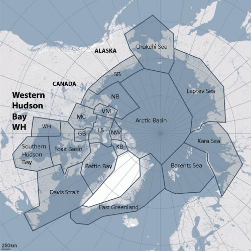
Polar bear subpopulations defined by the Polar Bear Specialist Group (PBSG). Courtesy the PBSG.

As far as I can determine, there are at least two that haven’t quite been finished: Baffin Bay and Southern Beaufort. The Baffin Bay survey was supposed to be completed this spring, so the numbers just need to be crunched. Southern Beaufort has a survey in progress, planned to continue through the fall of 2013.

Here are some comments on the 2012 Southern Beaufort field season (USFWS Newletter 2013:17):

“The number of polar bears observed in 2012 was high relative to similar surveys conducted over the past decade. During August and September surveys, the majority of bears were observed east of Prudhoe Bay, primarily near Kaktovik. Body condition appeared relatively normal for this time of year with most bears reported to be in average condition.” [my bold] [see previous post here re: Kaktovik bears]

There are new counts for Foxe Basin (estimated at ~2,580 bears, similar to the early 1990s estimate of ~2,200; Stapleton, Peacock and Garshelis 2012) and Western Hudson Bay (estimated at ~1,000 bears, similar to the 2004 estimate of ~935; Stapleton, Atkinson et al. 2012) based on aerial surveys. These numbers have not yet been incorporated into the global total, although the studies suggest both of those populations have been stable since the last survey.

CBC News (June 26, 2012):

“A study has found that the polar bear population in the Foxe Basin region of Nunavut is stable and the bears are in good health.

The territorial government did an aerial survey of the bear population in 2009 and 2010. The survey results show the population is about the same size as it was in 1990 – about 2,580 bears.” [my bold]

There is also the new population estimate for Davis Strait (Peacock et al. 2013) that needs to be incorporated into the global total – in this case, there has been an increase from the previous estimate (up from ~1,400 to ~2,158). [corrected Oct. 14 2013] The population increase for Davis Strait has already been incorporated into the current global estimate. The new numbers were available by 2009 (the time of the last PBSG meeting) but the peer-reviewed publications (with all of the pertinent details) were not produced until recently (2012-2013, discussed here and here).
Continue reading

Baffin Bay-Davis Strait ice concentration comparison – why use the “summer mean”?

I’ve been in the process of looking at the status of polar bears in the Baffin Bay region, which lies to the north of Davis Strait (Fig. 1), but a related issue caught my attention that I think deserves discussion.

Figure 1. Polar bear subpopulations defined by the Polar Bear Specialist Group (PBSG). Note that Baffin Bay, Davis Strait, Western Hudson Bay and Southern Hudson Bay are all similar in that they become ice-free by early fall (the September minimum) or before.

Figure 1. Polar bear subpopulations defined by the Polar Bear Specialist Group (PBSG). Note that Baffin Bay, Davis Strait, Western Hudson Bay and Southern Hudson Bay are all similar in that they become ice-free by early fall (the September minimum) or even before.

Recall that in a recent post on the Beaufort Sea ice extent comparison offered by the National Snow and Ice Data Center (NSIDC) here, I commented:

What puzzled me was why they featured only the last 7 years when satellite data go back to at least 1979. Is there something in that data they don’t want us to see?”

Something similar struck me about the analysis of sea ice in Baffin Bay and Davis Strait conducted by polar bear researchers Karyn Rode and colleagues (Rode et al. 2012). In their comparison of body condition (relative fatness) of bears in Davis Strait and Baffin Bay (see previous post here), they introduced an entirely new sea ice metric – “mean daily summer sea ice concentration,” defined as the mean of values between May 15 and October 15 each year based on ice charts provided by the Canadian Ice Service.

Why invent a metric that has never been used (as far as I know) for analysis of polar bear health, survival or success?

Why not use breakup dates, as has been done for decades for subpopulations in Hudson Bay (e.g. Cherry et al. 2013), where the ice also disappears in late summer?

Is there something in the ice data for Baffin Bay and Davis Strait that Rode and colleagues don’t want us to see?

Since I had already made a composite of Cryosphere Today ice maps at July 12 for my discussion of the Chukchi/Beaufort NSIDC analysis mentioned above, it was relatively easy to look at what was going on in Baffin Bay and Davis Strait on that date in mid-summer. Keep in mind that ice extent and concentration at July 12 records the state of polar bear habitat prior to the late summer decline in sea ice that occurs every year.

Continue reading