Tag Archives: Beaufort Sea

Tracking polar bears in the Beaufort Sea: December map

Here is the December 2013 follow-up to my post on the July track map for female polar bears being followed by satellite in the Beaufort Sea by the US Geological Survey (USGS) – Ten out of ten polar bears being tracked this summer in the Beaufort Sea are on the ice.

See that post for methods and other background on this topic, and some track maps from 2012 (also available at the USGS website here).

The track map for December 2013 is copied below (Figure 1).

There has been little change from November: six of the bears that were being tracked in October were still present (down from ten in July) and one bear that went Arctic walkabout in October has returned and is still in the area. The same seven bears present in November were still being tracked in December but did not move very much. Continue reading

Tracking polar bears in the Beaufort Sea: November map

Here is the November follow-up to my post on the July track map for female polar bears being followed by satellite in the Beaufort Sea by the US Geological Survey (USGS) – Ten out of ten polar bears being tracked this summer in the Beaufort Sea are on the ice.

See that post for methods and other background on this topic, and some track maps from 2012 (also available at the USGS website here).

The track map for November is copied below (Figure 1).

By the end of November, ice covered the entire Alaska coast. Six of the bears that were being tracked in October were still present (down from ten in July) and one bear that went Arctic walkabout in October has returned. So, a total of seven bears were tracked in November.
Continue reading

Tracking polar bears in the Beaufort Sea: October map

Here is the October follow-up to my post on the July track map for female polar bears being followed by satellite in the Beaufort Sea by the US Geological Survey (USGS) – Ten out of ten polar bears being tracked this summer in the Beaufort Sea are on the ice. See that post for methods and other background on this topic, and some track maps from 2012 (also available at the USGS website here).

The track map for October is copied below (Figure 1).

By the end of October, ice reached the coast in several areas. The ten bears from July were down to seven – their collars might have stopped working or fallen off (most likely), they might have left the area entirely (also possible) or they might have died (the researchers don’t say which).
Continue reading

Polar bear cannibalism and sea ice, the spring of 1976

Remember Ian Stirling’s claim that late freeze up in Western Hudson Bay in 2009 was forcing polar bears to resort to cannibalism (here and here), with gut-wrenching images and video provided for the media? Or Steve Amstrup’s claim for a similar phenomenon in the Southern Beaufort in 2004?

I pointed out that Stirling’s claim was way overblown and that Amstrup’s incidents were almost certainly the result of heavy ice in the spring (not low ice in summer), similar to the heavy ice conditions and polar bear starvation documented in the same region back in 1974-1976.

It turns out that the heavy ice conditions documented in the Eastern Beaufort in the mid-1970s had much broader effects on polar bears and ringed seals than has been appreciated.
Continue reading

Tracking polar bears in the Beaufort Sea: September map

Here is the follow-up to my post on the July track map for polar bears being followed by satellite in the Beaufort Sea by the US Geological Survey (USGS) – Ten out of ten polar bears being tracked this summer in the Beaufort Sea are on the ice. See that post for methods and other background on this topic, and some track maps from 2012 (also available at the USGS website here).

The track map for September was posted on the USGS website on October 17 (delayed due to the US government shutdown) and is copied here below (Figure 1). The ice rebounded during the second half of the month (after the annual minimum was reached on September 13). The ten bears from July were down to eight – their collars might have stopped working or fallen off (most likely), they might have left the area entirely (also possible) or they might have died (the researchers don’t say which).

Figure 1. “Movements of 8 satellite-tagged polar bears for the month of September, 2013. Polar bears were tagged in 2013 on the spring-time sea ice of the southern Beaufort Sea. All 8 of these bears have satellite collar transmitters [i.e., all are females]. Polar bear satellite telemetry data are shown with Ice Analysis charts from 26 August, 2013. Ice Analysis charts are made available by the National Ice Center. The land cover is made available by Natural Earth. Click on the above image to enlarge.” [Note that the dots with the polar bear icons are the end points (end September), while the other end of the string is their position in early September, indicating that the ice is now moving towards the shore. The pink dot present in August is almost entirely obscured by the purple dot, on shore in Alaska and the light brown dot is ashore on Banks Island, centre right of the map; two of the bears present in July (see Fig. 2 below) are no longer being tracked - their collars might have stopped working or fallen off (most likely), they might have left the area entirely (also possible) or they might have died. The researchers don’t say.] Click to enlarge

Figure 1. Original caption: “Movements of 8 satellite-tagged polar bears for the month of September, 2013. Polar bears were tagged in 2013 on the spring-time sea ice of the southern Beaufort Sea. All 8 of these bears have satellite collar transmitters [i.e., all are females]. Polar bear satellite telemetry data are shown with Ice Analysis charts from 26 August, 2013. Ice Analysis charts are made available by the National Ice Center. The land cover is made available by Natural Earth. Click on the above image to enlarge.” [Note that the dots with the polar bear icons are the end points (end September), while the other end of the string is their position in early September, indicating that the ice is now moving towards the shore. The pink dot present in August is almost entirely obscured by the purple dot, which is overlapping the yellow dot on shore in Alaska; also, the light brown dot is on Banks Island, far right.]

It appears that of the eight polar bears still being followed by USGS researchers in September, four are on shore and four are still on the ice. Only time will tell if the four females on shore are pregnant and preparing maternity dens for the winter, but this seems the likely reason they are not on the ice with the others.

One very interesting point worth noting:
the one bear (light brown) captured onshore in the Southern Beaufort subpopulation region in the spring of 2013, has moved into the Northern Beaufort subpopulation region, on Banks Island (see map here), and may be denning there. This inter-subpopulation movement is relatively uncommon.

The map for July 2013 is below, for comparison: Continue reading

Kaktovik polar bears could be back on the ice this weekend

This is a quick follow up on my last post (here) on Kaktovik polar bears of the Southern Beaufort Sea subpopulation.

Kaktovik is the bright pink dot on the ice map below (October 3, 2013: click to enlarge), from the Canadian Ice Service – if the ice doesn’t get to the polar bears waiting on shore this weekend, it will be within swimming distance.

Note that this map doesn’t show the shorefast ice that is already forming along the beaches, bridging the gap between land and the offshore ice.

Shorefast ice provides the fall’s first ice platform for polar bears to hunt seals. It doesn’t need to be extensive for the bears to get out there — researchers working in Western Hudson Bay found that an ice concentration of only 10% marked the point when polar bears left the shore.

Kaktovik on CIS chart Oct 3 2013

Polar bears at Kaktovik, Alaska not stranded due to retreating ice

“I’ve lived here all my life and there are more bears every year. I read stories about polar bears being on the brink of extinction because of global warming, look out of my window and start to laugh.” Tori Sims, Kaktovik (Mail on Sunday, Sept. 28, 2013).

As you can see, Kaktovik is in the news again. This tiny community sits on the edge of the Beaufort Sea, on Barter Island on the North Slope of Alaska (Fig. 1). It lies within the Southern Beaufort polar bear subpopulation, which has been classified as “declining” by the IUCN Polar Bear Specialist Group (Obbard et al. 2010).

The determination of “declining” was based on a small dip in population numbers between 2001 and 2006 (not statistically significant), plus a decline in body size and condition, and smaller litter sizes documented between 1986 and 2006 (Rode et al. 2010). A new population survey is underway.

Figure 1. Kaktovik, Alaska, from Google maps.

Figure 1. Kaktovik, Alaska, from Google maps. Click to enlarge.

There have been suggestions that bears become “stranded” along the Alaska coast near Kaktovik because of retreating sea ice, and that more bears present in this area in recent years are an indication that they are in trouble due to global warming.

I’ve compiled some quotes, maps, and links to stories, photos and videos about Kaktovik polar bears to show that this claim is false.

Continue reading

Record sea ice loss in 2007 had no effect on polar bears, Chukchi study confirms

One aspect of the recently published study on Chukchi Sea polar bears (Rode et al.2014 [now in print] 2013; see here and here) has not been stressed enough: their finding that the differences in overall condition between bears in the Chukchi and Southern Beaufort Seas came down to disparities in spring feeding opportunities and therefore, the condition of spring sea ice.

The fact that spring — not summer — is the most critical period for polar bears is something I’ve pointed out before (see here and here, for example) but it’s worth repeating at this time of year, when all eyes are on the annual ice minimum. It is often treated as a given that the decline in extent of summer sea ice in the Arctic since 1979 has been detrimental to polar bears. However, this is an assumption that we can now say is not supported by scientific evidence (see summary of that evidence here).

The results published by Rode et al. (2014 2013) not only add further support to the conclusion that declines in summer sea ice have not harmed polar bears, but should put the matter to rest – unless new evidence to the contrary is produced.

Chukchi bears, the report tells us, had more food available in the spring than Southern Beaufort bears (see map below) and this was the primary reason that bears were doing very well in the Chukchi and not quite as well in the Southern Beaufort. And because the polar bears for this study were captured and measured in mid-March to early May, from 2008 to 2011, they reflect spring-time conditions for 2008-2011 as well as year-round conditions from 2007 through 2010.

This means that the annual low ice extent for 2007 (record-breaking at the time), in the fall before this study began, had no discernible negative effect on either Chukchi or Southern Beaufort polar bears – and neither did similarly low annual minimums in two of the three remaining years of the study (Fig 1).

Figure 1. Sea ice extent at August 27, 2007 – the lowest extent that year (downloaded September 15, 2013 from IARC-JAXA, Arctic Sea-ice Monitor). At the time, it was the lowest extent recorded since 1979 (2012 broke that record). This (2007) was the fall before the Rode & Regehr study on Chukchi/Southern Beaufort polar bears began (2008-2011). The ice was almost as low in September 2008 and 2010, while 2009 was more like 2013.

Figure 1. Sea ice extent at August 27, 2007 – the lowest extent that year (downloaded September 15, 2013 from IARC-JAXA, Arctic Sea-ice Monitor). At the time, it was the lowest extent recorded since 1979 (2012 broke that record). This (2007) was the fall before the Rode & Regehr study on Chukchi/Southern Beaufort polar bears began (2008-2011). The ice was almost as low in 2008 and 2010, while 2009 was more like 2013.

Continue reading

How and why great news about Chukchi polar bears has been suppressed

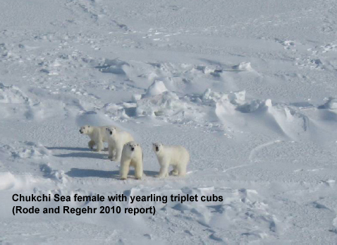
A new peer-reviewed report (Rode et al. 2014 [in print] 2013, accepted), released last month (announced here), documents the fact that polar bears in the Chukchi Sea are doing better than virtually any other population studied, despite significant losses in summer sea ice over the last two decades – even though the Polar Bear Specialist Group (PBSG) said this population was declining (Obbard et al. 2010).

Rode and Regehr 2010_Chukchi_report2010_Fig1_triplets_labelled

Rather than this good news being shouted far and wide, what we’ve seen so far is a mere whisper. The strategy for suppressing the information appears to have several parts: make it hard to find; don’t actively publicize it; down-play the spectacularly good nature of the news; minimize how wrong they were; keep the focus on the future.

Something similar happened with the newly-published paper on Davis Strait bears (Peacock et al. 2013, discussed here and here) but the news there wasn’t quite so shockingly different from expected. The suppression of good news stands in marked contrast to anything with a hint of bad news, which gets reported around the world — for example, Andrew Derocher and colleagues and their prepare now to save polar bears” policy paper in February, 2013.

US Fish & Wildlife biologist Eric Regehr, co-investigator of the Chukchi study and co-author of the newly-published report, wrote an announcement about the paper. It wasn’t a real press release, since it was not actually sent to media outlets. It was a statement, with a brief summary of the paper, posted on a regional US Fish & Wildlife website, with no mention of lead author Karyn Rode. Not surprisingly, lack of active promotion = no media coverage.

The posted announcement also down-played how well the Chukchi bears are doing. In fact, the news documented in the paper is much better than any of them let on: Chukchi polar bears are doing better than virtually all other populations studied.

But Regehr also had to do some damage control to counter the evidence this paper contains of how wrong they had all been — not only about the Chukchi population today but about their predictions for polar bears in the future.

After all, the computer models used to predict a dire future for polar bears combined the Chukchi Sea with the Southern Beaufort, as having similar ice habitats (“ice ecoregions”). The published paper and Regehr’s statement now say these two regions are very different and that polar bear response to loss of sea ice is “complex” rather than a simple matter of less summer ice = harm to polar bears. Regehr goes on to say that polar bear scientists expected this would happen. I call total BS on this one, which I explain in full later (with a map).

Finally, Regehr’s statement emphasizes that good news for 1 subpopulation out of 19 today should not be celebrated because the overall future for polar bears — prophesied by computerized crystal balls — is bleak. Focus on the future, they say. Did they forget that for years they’ve been telling us that polar bears are already being harmed and that this foreshadows what’s to come? Now we have the results of yet another peer-reviewed study showing bears not being harmed by declines in summer ice (see the full list here).

So, in the end, all of this double-talk and contradiction is not just about suppressing this particular paper. There’s much more at stake.

The Rode et al. Chukchi paper is strong evidence that their predictions of a grim future for polar bears – based on theoretical responses to summer sea ice declines that should already be apparent – have been refuted by their own studies. It’s no wonder they want to keep the media away from this story.

Details below.  [Update September 11, 2013: another news outlet picks up the story, see Point 2 below]

Continue reading

Tracking polar bears in the Beaufort Sea: August map

Here is the follow-up I promised to my post on the July track map for polar bears being followed by satellite in the Beaufort Sea by the US Geological Survey (USGS) – Ten out of ten polar bears being tracked this summer in the Beaufort Sea are on the ice. See that post for methods and other background on this topic, and some track maps from 2012.

The track map for August was posted on the USGS website on September 4th and is copied here below (Figure 1). The ice moved a bit further offshore during August but not nearly as far as it did in 2012. The ten bears from July were down to eight – their collars might have stopped working or fallen off (most likely), they might have left the area entirely (also possible) or they might have died (the researchers don’t say which).

 Figure 1. “Movements of 8 satellite-tagged polar bears for the month of August, 2013. Polar bears were tagged in 2013 on the spring-time sea ice of the southern Beaufort Sea. All 8 of these bears have satellite collar transmitters [i.e., all are females]. Polar bear satellite telemetry data are shown with Ice Analysis charts from 26 August, 2013. Ice Analysis charts are made available by the National Ice Center. The land cover is made available by Natural Earth. Click on the above image to enlarge.”[Note that the dots with the polar bear icons are the end points (end August), while the other end of the string is their position in early August. The yellow dot is behind the purple dot, on shore; two of the bears present in July (see Fig. 2 below) are no longer being tracked - their collars might have stopped working or fallen off (most likely), they might have left the area entirely (also possible) or they might have died. The researchers don’t say.]


Figure 1. “Movements of 8 satellite-tagged polar bears for the month of August, 2013. Polar bears were tagged in 2013 on the spring-time sea ice of the southern Beaufort Sea. All 8 of these bears have satellite collar transmitters [i.e., all are females]. Polar bear satellite telemetry data are shown with Ice Analysis charts from 26 August, 2013. Ice Analysis charts are made available by the National Ice Center. The land cover is made available by Natural Earth. Click on the above image to enlarge.” [Note that the dots with the polar bear icons are the end points (end August), while the other end of the string is their position in early August. The yellow dot is behind the purple dot, on shore; two of the bears present in July (see Fig. 2 below) are no longer being tracked – their collars might have stopped working or fallen off (most likely), they might have left the area entirely (also possible) or they might have died. The researchers don’t say.]

So, of the eight polar bears still being followed by USGS researchers in August, three were on shore and five were on the ice. Only time will tell if the three females on shore are pregnant and preparing maternity dens for the winter, but this seems the likely reason they are not on the ice with the others.

I’ll post the track map for September when it is available in early October at the USGS website.

The map for July 2013 is below, for comparison: Continue reading