Tag Archives: onshore

Churchill problem polar bear report for 7-13 September 2015

Latest report on problem bears in Churchill, Manitoba, from the town’s Facebook page. See previous post here for map and background.

19 polar bears handled to date this year; 12 bears in the holding facility.

Polar bear-TRANSPORTED-TO-POLAR-PRISON_w Huff Post 2011

Photo above: A bear is transported to Churchill’s polar bear holding facility (from a 2011 Huffington Post article, “Polar Bear Prison”).

Activity report for 7-14 September 2015 copied below (click to enlarge):

2015 Sept 7-13_at Sept 14

Well-fed polar bears onshore at height of summer easily deterred by noise, CBC reports

From the CBC this morning, we have the report of a female polar bear and her cub paying a visit to an Nunavut campsite near Chesterfield Inlet in northwestern Hudson Bay, which is technically within the boundary of the Foxe Basin polar bear subpopulation.

Maggie Putulik photo, 29 July 2015 Chesterfield Inlet, Nunavut.

Maggie Putulik photo, 29 July 2015 Chesterfield Inlet, Nunavut.

These are not the desperate bear victims of global warming we have been warned about by polar bear specialists but well-fed curious ursids not averse to an easy meal if there’s one to be had. Such bears are easily deterred by a loud noise. Note this was the second visit by polar bears this Nunavut family had experienced at this location within a three-week period – two other bears had stopped by earlier. Note that ice in this region of Hudson Bay broke up earlier than usual this year yet these bears seem to be in fine condition and can expect the first fall ice of the season (freeze-up) to appear in their neighbourhood, see maps below.
Continue reading

Hudson Bay ice update – researchers awfully quiet about what polar bears are doing

This year 225 thousand km2 of sea ice remained on Hudson Bay at 10 August compared to 96 thousand km2 in 2009, the last late breakup year for which there are detailed ice maps and polar bear data.

Hudson Bay breakup Aug 10 2015_CIS

In 2009, most Western Hudson Bay polar bears were onshore by 22 August, just after the very last remnants of ice disappeared (see map below). This year? The remaining ice is further east, in Southern Hudson Bay territory.  Last report from a few weeks ago showed some Southern Hudson Bay bears came ashore early but past behavior suggests some bears will wait until the bitter end before they come ashore – until the very last remnants of ice disappear (Cherry et al. 2013).
Continue reading

July 2015: all 13 collared polar bears in the Southern Beaufort are out on the sea ice

Most of these bears are close enough to shore to hit the beach if that’s where they wanted to be but they’re on the sea ice.

Polar bear S Beaufort_PolarBearNews2010

I’ve been posting these USGS tracking maps for two years.1  The map archive at USGS goes back to December 2009.  Seeing all animals on the ice in July is usual for Southern Beaufort polar bears.

During August, a few of these females usually come ashore (see here and here), probably because they plan to den there later. But most polar bear females stay out on the ice, no matter how far it contracts into the Arctic Basin. Only about 5% of SB bears spend time on land during the summer.

See the July track map below and some sea ice maps and graphs for the region.
Continue reading

Sea ice breakup update: high ice coverage just about everywhere, even Hudson Bay

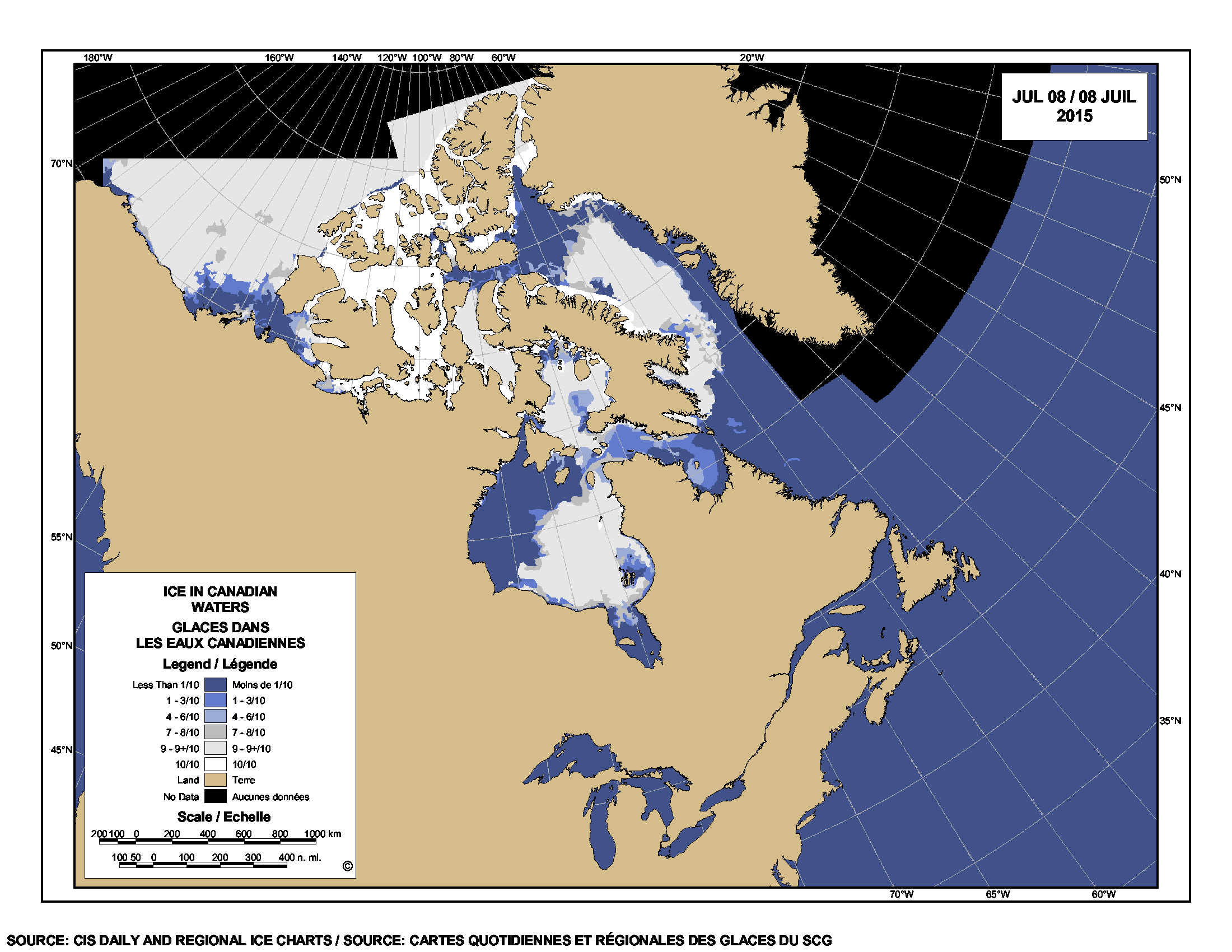
There is still a lot of sea ice in Hudson Bay, Foxe Basin, Davis Strait and Baffin Bay this week – more than average for this date – with slightly less than average in the Beaufort Sea. Past behaviour of Western and Southern Hudson Bay polar bears suggests the mean date that bears come ashore for the summer this year will be later than average due to the plentiful ice available, regardless of when polar bear biologists decide that “breakup” has occurred.

Hudson Bay breakup July 8 2015_CIS

Hudson Bay, with almost 50% of the bay still covered in ice, has the third highest coverage this week since 1992 (after 2009 and 2004); Davis Strait has the highest coverage since 1992; and Foxe Basin and Baffin Bay have the highest coverage since 1998. For this week, the Beaufort Sea has the second highest coverage since 2006 (after 2013), and more ice than was present in 1971, 1982, 1987, 1988 and 1998 – among others.

Published data shows that most polar bears of Western Hudson Bay traditionally come ashore in July, but this year it might be late July or even August. Have a look at the charts below.
Continue reading

Polar bear habitat update, December – still like 2009

From the end of October to mid-December, there has been a rapid expansion of polar bear habitat.

This month, I’ve constructed two all-in-one images that show the progressive growth of the ice relative to some critical polar bear onshore summer refuge areas and denning territory. I’ve also included a map that compares 2013 to 2009 at 18 December with the average for the 1980s, and one that shows ice thickness.
Continue reading

Extirpated polar bears of St. Matthew Island spent five months on land during the summer

Did you know there used to be resident polar bears on two small islands in the Bering Sea? Given how much we don’t know about the polar bears of the Bering Sea, the bears that used to den and spend their summers on the St. Matthew Islands are a bright spot. These islands lay at the southern-most limit of the modern “Chukchi Sea” subpopulation (see Fig. 1) and were uninhabited by people when they were discovered in the 1760s – but they were a haven for polar bears.

We have details of the polar bears that gave birth and summered there because a US government biologist (Henry Wood Elliott) and a US navy Lieutenant (Washburn Maynard) surveyed the islands in 1874. Elliott wrote both an official report and a popular magazine article (for Harper’s Weekly Journal of Civilization) in 1875 describing the polar bears they saw; Maynard wrote a separate report in 1876. By 1899, there were none left, victims of the relentless slaughter of polar bears everywhere in the Arctic in that era (see previous discussion here).

Figure 1. St. Matthew Island is in the Bering Sea off the west coast of Alaska: north of the Pribilofs and south of St. Lawrence Island, at about 60°N latitude. Compare this to the southern end of James Bay, Canada – which has a stable population of polar bears – at about 53 0N and Churchill, Manitoba – the “polar bear capital of the world” – at 58 046’N. Maps from Wikipedia.

Figure 1. St. Matthew Island is in the Bering Sea off the west coast of Alaska at about 60°N latitude. Compare this to the southern end of James Bay, Canada (which has a stable population of polar bears) at about 53 0N and Churchill, Manitoba (the so-called “polar bear capital of the world) at 58 046’N. Maps from Wikipedia.

Figure 2. A drawing of polar bears on St. Matthew Island that accompanied the May 1, 1875 Harper’s Weekly Journal of Civilization article written by Henry Elliot. See here.

Figure 2. A drawing of polar bears on St. Matthew Island that accompanied the May 1, 1875 Harper’s Weekly Journal of Civilization article written by Henry Elliot. See here.

[UPDATE: Jan. 27, 2013: a follow-up to this post is here.]

Continue reading