Tag Archives: Rode

Record sea ice loss in 2007 had no effect on polar bears, Chukchi study confirms

One aspect of the recently published study on Chukchi Sea polar bears (Rode et al.2014 [now in print] 2013; see here and here) has not been stressed enough: their finding that the differences in overall condition between bears in the Chukchi and Southern Beaufort Seas came down to disparities in spring feeding opportunities and therefore, the condition of spring sea ice.

The fact that spring — not summer — is the most critical period for polar bears is something I’ve pointed out before (see here and here, for example) but it’s worth repeating at this time of year, when all eyes are on the annual ice minimum. It is often treated as a given that the decline in extent of summer sea ice in the Arctic since 1979 has been detrimental to polar bears. However, this is an assumption that we can now say is not supported by scientific evidence (see summary of that evidence here).

The results published by Rode et al. (2014 2013) not only add further support to the conclusion that declines in summer sea ice have not harmed polar bears, but should put the matter to rest – unless new evidence to the contrary is produced.

Chukchi bears, the report tells us, had more food available in the spring than Southern Beaufort bears (see map below) and this was the primary reason that bears were doing very well in the Chukchi and not quite as well in the Southern Beaufort. And because the polar bears for this study were captured and measured in mid-March to early May, from 2008 to 2011, they reflect spring-time conditions for 2008-2011 as well as year-round conditions from 2007 through 2010.

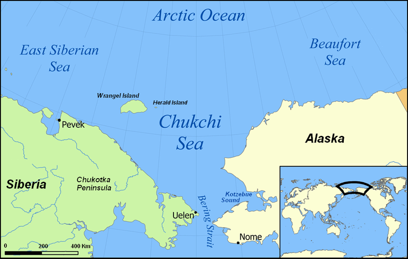
This means that the annual low ice extent for 2007 (record-breaking at the time), in the fall before this study began, had no discernible negative effect on either Chukchi or Southern Beaufort polar bears – and neither did similarly low annual minimums in two of the three remaining years of the study (Fig 1).

Figure 1. Sea ice extent at August 27, 2007 – the lowest extent that year (downloaded September 15, 2013 from IARC-JAXA, Arctic Sea-ice Monitor). At the time, it was the lowest extent recorded since 1979 (2012 broke that record). This (2007) was the fall before the Rode & Regehr study on Chukchi/Southern Beaufort polar bears began (2008-2011). The ice was almost as low in September 2008 and 2010, while 2009 was more like 2013.

Figure 1. Sea ice extent at August 27, 2007 – the lowest extent that year (downloaded September 15, 2013 from IARC-JAXA, Arctic Sea-ice Monitor). At the time, it was the lowest extent recorded since 1979 (2012 broke that record). This (2007) was the fall before the Rode & Regehr study on Chukchi/Southern Beaufort polar bears began (2008-2011). The ice was almost as low in 2008 and 2010, while 2009 was more like 2013.

Continue reading

Tracking polar bears in the Beaufort Sea: August map

Here is the follow-up I promised to my post on the July track map for polar bears being followed by satellite in the Beaufort Sea by the US Geological Survey (USGS) – Ten out of ten polar bears being tracked this summer in the Beaufort Sea are on the ice. See that post for methods and other background on this topic, and some track maps from 2012.

The track map for August was posted on the USGS website on September 4th and is copied here below (Figure 1). The ice moved a bit further offshore during August but not nearly as far as it did in 2012. The ten bears from July were down to eight – their collars might have stopped working or fallen off (most likely), they might have left the area entirely (also possible) or they might have died (the researchers don’t say which).

 Figure 1. “Movements of 8 satellite-tagged polar bears for the month of August, 2013. Polar bears were tagged in 2013 on the spring-time sea ice of the southern Beaufort Sea. All 8 of these bears have satellite collar transmitters [i.e., all are females]. Polar bear satellite telemetry data are shown with Ice Analysis charts from 26 August, 2013. Ice Analysis charts are made available by the National Ice Center. The land cover is made available by Natural Earth. Click on the above image to enlarge.”[Note that the dots with the polar bear icons are the end points (end August), while the other end of the string is their position in early August. The yellow dot is behind the purple dot, on shore; two of the bears present in July (see Fig. 2 below) are no longer being tracked - their collars might have stopped working or fallen off (most likely), they might have left the area entirely (also possible) or they might have died. The researchers don’t say.]


Figure 1. “Movements of 8 satellite-tagged polar bears for the month of August, 2013. Polar bears were tagged in 2013 on the spring-time sea ice of the southern Beaufort Sea. All 8 of these bears have satellite collar transmitters [i.e., all are females]. Polar bear satellite telemetry data are shown with Ice Analysis charts from 26 August, 2013. Ice Analysis charts are made available by the National Ice Center. The land cover is made available by Natural Earth. Click on the above image to enlarge.” [Note that the dots with the polar bear icons are the end points (end August), while the other end of the string is their position in early August. The yellow dot is behind the purple dot, on shore; two of the bears present in July (see Fig. 2 below) are no longer being tracked – their collars might have stopped working or fallen off (most likely), they might have left the area entirely (also possible) or they might have died. The researchers don’t say.]

So, of the eight polar bears still being followed by USGS researchers in August, three were on shore and five were on the ice. Only time will tell if the three females on shore are pregnant and preparing maternity dens for the winter, but this seems the likely reason they are not on the ice with the others.

I’ll post the track map for September when it is available in early October at the USGS website.

The map for July 2013 is below, for comparison: Continue reading

Ten out of ten polar bears being tracked this summer in the Beaufort Sea are on the ice

PB_male on ice_Regehr USFWS_March 2010_labeledTracking Beaufort Sea polar bears over the summer — what can it tell us about how important the position of summer sea ice relative to the shoreline in this region is to these bears? Do Beaufort Sea bears get stranded on shore like the polar bears in Davis Strait and Hudson Bay?

Polar bear biologist Eric Regehr (with the US Fish & Wildlife Service, or FWS) has a team working with US Geological Survey researchers (USGS) in the southern Beaufort tracking where adult female polar bears go throughout the year. This is part of on-going research in the Beaufort and Chukchi Sea (see previous post here; see also Fish & Wildlife 2009; Polar Bear News 2010 and 2013; Rode and Regehr 2010, pdfs below; and just out, the “accepted” version of the Rode et al. paper discussed here, and announced in my last post here).

The researchers have been posting a summary map at the end of each month on the USGS website showing the tracks of the females they fitted with radio collars the previous spring — for 2013, and back to 2010. They can’t put collars on male bears because their necks are larger around than their heads, so a collar would just slip off.

I’ve posted the July 2013 track map below, which shows all ten bears out on the ice, and the previous month (June 2013) to compare it to (the August map should be out shortly). I’ve included a few maps from 2012 to allow you to compare this year’s results to the situation last summer.

The August tracks should be available after the Labour Day weekend – check back next week to see where the bears have been this month. I’ll post the map here or you can go to the USGS website directly. [UPDATE Sept 4, 2013: The August map is up, posted here.]

Continue reading

Good news about Chukchi Sea polar bears whispered by US Fish & Wildlife Service

Just out: the “accepted” version of the Rode et al. paper discussed here last month — detailing just how well polar bears in the Chukchi Sea subpopulation are doing, despite recent declines in sea ice.

However, what was decidedly odd was how I found out about it.

Yesterday (Aug 28), while looking for something else, I found a “press release” tweeted by World Wildlife Fund (WWF) employee Geoff York, who is now also a full voting member of the Polar Bear Specialist Group (PBSG).

Chukchi bears press release tweet_Geoff York Aug 28 2013

The announcement that York tweeted is listed as “alaska.fws.gov/external/newsroom/pdf/cs_polar_bear_article.pdf” and I found a stand-alone copy of the pdf with that title on Google.

However, FWS has so far (Aug. 29, 7:00 am PT) not mentioned this item on their [central] website, their twitter account, or their Facebook page (pdf here, with its original title). The “press release” has no date and is not on FWS letterhead but is authored by “Eric V. Regehr, U.S. Fish & Wildlife Service.” [I guess FWS employees can issue their own press releases?] UPDATE: Found it finally in the “FWS Alaska region” (Alaska FWS, posted Aug. 22, 2013, which included the Eric Regehr summary tweeted by York), via a news report at SitNews dated Aug. 27. Mystery solved]

Also odd that so far, no one except Geoff York himself seems to have picked it up (nothing so far on WWF website or Facebook page, Polar Bears International pages, or at ScienceDaily. [Update: see news report at SitNews dated Aug. 27. Still odd that the FWS report has been sitting there quietly since the 22nd (Thursday of last week)]

Not exactly how I’d choose to spread good news, but perhaps that’s the point.

Nevertheless, not too much new in the paper itself [contact me if you’d like a copy] – no population size estimate, for example – other than what I included in the summary provided last month (based on a March presentation by lead author Karyn Rode), except this: spring litter sizes [1.90 in 2007 and 2.17 in 2009 on Wrangel Island] were “are among the highest reported for 18 of 19 polar bear populations” and were similar to litter sizes 20 years earlier.

I guess the picture of the Chukchi female with a litter of triplet yearling cubs included without mention in the 2010 Rode and Regehr report (pdf here, copied below, discussed previously here) was significant after all.

Rode and Regehr 2010_Chukchi_report2010_Fig1_triplets_labelled

Continue reading

Baffin Bay polar bear status – waiting for the count

Here’s a quick summary of the status of Baffin Bay polar bears, a subpopulation I’ve not previously discussed in detail. Nothing especially earth-shattering here, except perhaps to wonder about the involvement of the World Wildlife Fund (WWF) in a new helicopter survey of the region.

Baffin Bay (Fig. 1) is north of Davis Strait. It lies between western Greenland and Baffin Island in the eastern Arctic.

Unlike the other north/south neighbour-pair of Western/Southern Hudson Bay   (which I discussed previously), the sea ice history for Baffin Bay/Davis Strait is not as similar: Davis Strait bears have a much longer on-shore fast than Baffin Bay bears (see last post here). However, all four of these subpopulations have ‘seasonal sea ice’ – that is, the ice melts completely in late mid-to-late summer, forcing bears onshore for varying lengths of time until fall freeze-up.

Figure 1. The Baffin Bay subpopulation region lies north of Davis Strait (map on the left from Vongraven and Peacock 2011: Fig. 3) and management is shared between Canada (Nunavut) and Greenland. In total area, it covers 1.08 million km2 and its “suitable ice habitat in spring” (according to Taylor and Lee 1995) is 413,500 km,2 somewhat less than Davis Strait. The map on the right shows the sea ice extent at the end of March 2010 (NSIDC), the winter maximum.

Figure 1. The Baffin Bay subpopulation region lies north of Davis Strait (map on the left from Vongraven and Peacock 2011: Fig. 3) and management is shared between Canada (Nunavut) and Greenland. In total area, it covers 1.08 million km2 and its “suitable ice habitat in spring” (according to Taylor and Lee 1995) is 413,500 km2, somewhat less than Davis Strait. The map on the right shows the sea ice extent at the end of March 2010 (NSIDC), the winter maximum.

A peer-reviewed paper published last year (Rode et al. 2012) compared body condition vs. sea ice changes in Davis Strait and Baffin Bay (discussed here). But while that research contributed to an updated population estimate for Davis Strait (Peacock et al. 2013, discussed here), it did not do the same for Baffin Bay. This is likely because the body condition work in Baffin Bay was split between spring and fall, and it has already been determined that many Baffin Bay bears are offshore in the spring and not available for counting using shore-based methods.

That’s a shame, because the last population estimate was completed back in 1997 (Taylor et al. 2005) and it is now seriously out of date.

However, it appears the Government of Nunavut is currently in the process of surveying this region by helicopter, so a new population estimate should be available soon.

But this aspect of the survey might surprise you — a press release issued February 11, 2013 by WWF contained the following statement:

Results from the above-noted surveys will be completed and shared beginning in April 2013.

WWF made contributions of $82,000 to the Government of the Northwest Territories and $111,000 to the Government of Nunavut via Environment Canada, towards the total costs of these surveys. These funds were raised through the Arctic Home campaign from engaged Canadians and matched by The Coca-Cola Company.”  [my bold]

So, of the hundreds of millions the WWF pulls in from donations, they passed along less than $100,000 [$96,500 plus an equal contribution by Coca-Cola) to offset “the total costs of the survey.

We are not told what those total costs are, but I expect they run well over a million dollars for a multiyear/multi-region project like this, perhaps over two million. Which makes $96,500 rather a drop in the bucket. That might have paid for some of the jet fuel for the helicopters used for the survey, but probably not all of it.

Status details below.
Continue reading

Great polar bear red herring in the Southern Beaufort

Red herring iconWe know that thick-ice springs occurred in 1974, 1975, 1986, 1992, 2004, and 2005 in the former ‘Eastern Beaufort’ – now the southern portion of the ‘Northern Beaufort’ and the eastern portion of the ‘Southern Beaufort.’ We know that these severe spring ice conditions negatively impacted both polar bears and ringed seals in this region every decade since the 1960s because the effects have been documented by numerous studies conducted in April through May for polar bears (Amstrup et al. 2006; Cherry et al. 2009; Pilfold et al. 2012; Stirling 2002; Stirling and Lunn 1997; Stirling et al. 1980; Stirling et al. 1993; Stirling et al. 2008) and in June and July for ringed seals (Harwood et al. 2012; Smith 1987), see previous posts here, here, and here.

For example, even though Ian Stirling and colleagues argued in their 2008 paper that the thick spring ice conditions in 2004, 2005 and 2006 (but not those in previous decades) were caused by storms initiated or intensified by greater amounts of open water in previous summers, they did not deny that the thick-ice springs occurred. They stated quite clearly that:

The 1960s, 1970s, and 1980s each experienced a two- to three-year decline in seal productivity in the eastern Beaufort Sea and Amundsen Gulf, associated with heavy ice conditions, around mid-decade. Each was followed by a decline in polar bear reproduction and condition, after which both seal and bear populations recovered (Smith, 1987; Harwood et al., 2000; Stirling, 2002). The beginning of each of those three periods was associated with heavy ice conditions through the winter before the reproductive decline of the seals, followed by a late spring breakup.” [my bold]

So, I have to say, I was shocked but not surprised to find that in the more recent scientific literature, the phenomenon of thick-ice springs every decade in Southern and Northern Beaufort has been deliberately ‘disappeared.’ 

Not surprised because I suspected it had happened — this issue was a feature of the Stirling and Derocher (2012) paper from late last year which was the topic of my very first blog post, “Cooling the polar bear spin.

However, I think it is important to document how the transmogrification of sea ice effects on polar bears was managed in the scientific literature so that everyone can see exactly what has been done. In a truly astonishing move for what is supposed to be a field of science, thick-ice springs have been effectively replaced by an open-water red herring as the scourge of Southern Beaufort polar bears.

Continue reading

Davis Strait polar bears again: body condition declined while population increased

This is a short follow-up to my last post on Davis Strait polar bears.

Today I’ll highlight a paper published last year (Rode et al. 2012) that had three of the same co-authors as the Peacock et al. (2012) paper I discussed on Monday – Lily Peacock, Mitch Taylor, and Ian Stirling contributed to both papers. Rode et al. (2012) deals with the issue of body condition (relative degree of fatness) in polar bears vs. changing levels of sea ice over time, and if you’ll pardon the pun, adds even more weight to the conclusion that declines in summer sea ice do not necessarily spell the disaster for polar bears we have been told is inevitable.

A polar bear near Thule, NW Greenland. Note the decidedly chubby back end on this bear, who looks well prepared for winter. Photo by Robin Davies. [details at my Quote Archive, Featured Quote #6]

A polar bear in the summer of 2012 near Thule, NW Greenland (part of the Baffin Bay subpopulation). Note the decidedly chubby back end on this bear, who looks well prepared for winter. Photo by Robin Davies.
[details at my Quote Archive, Featured Quote #6]

Continue reading

New Chukchi Sea polar bear survey – exciting preliminary results

Back in October, I wrote about US Fish & Wildlife biologist Eric Regehr comments about a recent survey of Chukchi Sea polar bears, the results of which are still not published. Since then, I’ve been able to track down a bit of information.

This project appears to have run for five years, from 2008 to 2011. The work was confined to the eastern (US) portion of the Chukchi, see maps below (Polar Bear News 2010; Rode and Regehr 2010). Researchers were doing mark-recapture work with helicopters, putting radio collars on some females and radio ear tags on a few males. They worked primarily in March and April (mating season for polar bears), operating entirely on the offshore sea ice – working, I might add, on bears that technically speaking do not exist, since the official population estimate for this region is “zero” (they are not included in the global estimate of 20,000-25,000, see pdf here,, discussed here).

Figure 1. Chukchi Sea – getting you oriented. Note the location of Kotzebue Sound, northeast of the Bering Strait. Map from Wikipedia.

Figure 1. Chukchi Sea – getting you oriented. Note the location of Kotzebue Sound, northeast of the Bering Strait. Map from Wikipedia.

In 2012, US Fish & Wildlife biologist Eric Regehr told reporter Jill Burke at Alaska Dispatch that they found the bears were “reproducing well and maintaining good body condition.” I’ve finally found some details regarding what he meant by that statement (although no final reports or peer-reviewed papers are out, see footnote below).

Continue reading