Tag Archives: Chukchi Sea

Spring/summer sea ice bonanza for polar bears – conditions excellent again for 2014

Again this year – contrary to predictions – there has been no early breakup of the sea ice on Hudson Bay and even though it’s the height of summer, there is plenty of ice throughout the Arctic to act as a feeding platform for polar bears. This makes it unlikely there will be a longer-than-average summer fast for polar bears again this year.

Figure 1. NSIDC MASIE map for June 21, 2014.

Figure 1. NSIDC MASIE map for June 21, 2014.

Sea ice maps around the Arctic for June 21 (and June 24, for Hudson Bay) reviewed and discussed below in relation to polar bear habitat — have a look.

Continue reading

Tracking polar bears in the Beaufort Sea – more bears added to the April 2014 map

Polar bears were tagged in 2013 and 2014 on the spring-time sea ice of the southern Beaufort Sea. Seventeen of these bears have satellite collar transmitters and 7 of these bears have glue-on satellite transmitters” say the folks at the USGS Alaska Science Center.

I guess that’s why the April map was late getting posted.

Polar bear ear tag_USFWS_PolarBearNews2010

Continue reading

Tracking polar bears in the Beaufort Sea – April map not yet available

Cannot do my April follow-up to my post on the July 2013 track map for female polar bears being followed by satellite in the Beaufort Sea by the US Geological Survey (USGS) – Ten out of ten polar bears being tracked this summer in the Beaufort Sea are on the ice.

“Tracking Polar Bears by Satellite” has not yet been updated with the April map, which is unusual for this late in the month (it is usually updated within the first few working days of every month). Perhaps the sea ice data they use was late being processed?

Here is the map for March, discussed previously here.

Figure 1. Movements of 5 satellite-tagged polar bears for the month of March, 2014. Polar bears were tagged in 2013 on the spring-time sea ice of the southern Beaufort Sea. All 5 of these bears have satellite collar transmitters. Note that the dots with the polar bear icons are the end points (end March), while the other end of the string is their position in early March. These are the same 5 females that were present in January. Click to enlarge.

Figure 1. Movements of 5 satellite-tagged polar bears for the month of March, 2014. Polar bears were tagged in 2013 on the spring-time sea ice of the southern Beaufort Sea. All 5 of these bears have satellite collar transmitters. Note that the dots with the polar bear icons are the end points (end March), while the other end of the string is their position in early March. These are the same 5 females that were present in January. Click to enlarge.

Previous dates for tracking available here.

Tracking polar bears in the Beaufort Sea: March map

Here is the March 2014 follow-up to my post on the July 2013 track map for female polar bears being followed by satellite in the Beaufort Sea by the US Geological Survey (USGS) – “Ten out of ten polar bears being tracked this summer in the Beaufort Sea are on the ice.”

See that post for methods and other background on this topic, and some track maps from 2012 (also available at the USGS website here).

The USGS track map March 2014 is copied below (Fig. 1).

Compare this to February’s map (Fig. 2) – you’ll be surprised at how little has changed!

Figure 1. Movements of 5 satellite-tagged polar bears for the month of March, 2014. Polar bears were tagged in 2013 on the spring-time sea ice of the southern Beaufort Sea. All 5 of these bears have satellite collar transmitters. Note that the dots with the polar bear icons are the end points (end March), while the other end of the string is their position in early March. These are the same 5 females that were present in January. Click to enlarge.

Figure 1. From original caption: “Movements of 5 satellite-tagged polar bears for the month of March, 2014. Polar bears were tagged in 2013 on the spring-time sea ice of the southern Beaufort Sea. All 5 of these bears have satellite collar transmitters.” Note that the dots with the polar bear icons are the end points (end March), while the other end of the string is their position in early March. These are the same 5 females that were present in January. Click to enlarge.

Continue reading

Southern Beaufort polar bear ‘decline’ & reduced cub survival touted in 2008 was invalid, PBSG now admits

It is now clear that the phenomenon of bears moving across Southern Beaufort Seapbsg logo subpopulation boundaries compromised the US decision to list polar bears as ‘threatened’ and the IUCN Polar Bear Specialist Group (PBSG) knows that was the case.

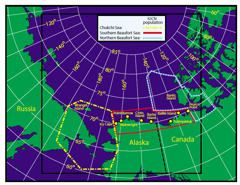
As I pointed out last week, the PBSG has admitted in their 2013 status table update (pdf here) that bears move around so much between the Chukchi Sea (CS), the Southern Beaufort (SB), and the Northern Beaufort (NB) subpopulations that major changes in the boundaries of the SB subpopulation are necessary (see Fig. 1 below).

Figure 1. From the paper by Amstrup and colleagues (2005) describing the effect that movement of bears across subpopulation boundaries has on setting harvest quotas – and population estimates. Southern Beaufort boundary is solid red, Chukchi Sea is dashed yellow and Northern Beaufort is dotted light blue. “Point Barrow” is Barrow, AK (well inside the SB boundary). Click to enlarge.

Figure 1. From the paper by Amstrup and colleagues (2005) describing the effect that movement of bears across subpopulation boundaries has on setting harvest quotas and population estimates. Southern Beaufort (SB) boundary is solid red, Chukchi Sea (CS) is dashed yellow and Northern Beaufort (NB) is dotted light blue. “Point Barrow” is Barrow, AK (well inside the SB boundary). Click to enlarge.

Well, that’s not really news — changes to the SB boundaries were promised by the PBSG back in 2009 (Obbard et al. 2010), based on research by Steven Amstrup and colleagues published in 2001 and 2005. But now, in an astonishing admission, the PBSG have acknowledged that the last population survey for the SB (Regehr, Amstrup and Stirling, 2006), which appeared to register a decline in population size and reduced cub survival over time, did not take known movements of bears into account as it should have done.

In other words, that 2006 study almost certainly did not indicate bears dying due to reduced summer sea ice in the SB, as biologists said at the time — and which they presented as evidence that polar bears should be listed by the ESA as ‘threatened’ — but reflected capture of bears that were never part of the SB subpopulation and so moved out of the region.

As the PBSG said about the 2006 estimate:

“…it is important to note that there is the potential for un-modeled spatial heterogeneity in mark-recapture sampling that could bias survival and abundance estimates.” [my emphasis]

Spatial heterogeneity” means that the sampled bears could have come from more than one population, a possibility which violates a critical requirement of the statistics used to generate the population and survival estimates. “Un-modeled” means that the ‘movement of bears’ problem was not factored into the mathematical models that generated the 2006 population size and survival estimates as it should have been.

Ecologist Jim Steele pointed some of this out in his book and his guest post last year, so it’s not news that this was done.

What’s shocking is that the PBSG have now admitted that the ‘movement of bears’ issue essentially invalidates the 2006 population estimate and the much-touted ‘reduced survival of cubs.’ The reduced survival of cubs data from that SB study was a critical component of the argument that US bears were already being negatively impacted by global warming and thus, should be listed as ‘threatened’ under the ESA (US Fish & Wildlife Service 2008).

Since the population decline and reduced survival is now acknowledged to be unfounded — and perhaps deliberately so — I ask you this: will a new SB survey — soon to be released by the same lead author (Eric Regehr) — undo the broken trust in US and PBSG polar bear biologists? Continue reading

Tracking polar bears in the Beaufort Sea: February map

Here is the February 2014 follow-up to my post on the July 2013 track map for female polar bears being followed by satellite in the Beaufort Sea by the US Geological Survey (USGS) – Ten out of ten polar bears being tracked this summer in the Beaufort Sea are on the ice.

See that post for methods and other background on this topic, and some track maps from 2012 (also available at the USGS website here).

The USGS track map February 2014 is copied below (Fig. 1).

Continue reading

Tracking polar bears in the Beaufort Sea: January map

Here is the January 2014 follow-up to my post on the July 2013 track map for female polar bears being followed by satellite in the Beaufort Sea by the US Geological Survey (USGS) – Ten out of ten polar bears being tracked this summer in the Beaufort Sea are on the ice.

See that post for methods and other background on this topic, and some track maps from 2012 (also available at the USGS website here).

The USGS track map for January 2014 is copied below (Fig. 1).

Both the Southern Beaufort and the Chukchi Sea were completely ice-covered by the end of January. The seven bears tracked during November and December were reduced to five in January — down 50% from the ten bears collared in July.
Continue reading

New interactive sea ice atlas for Alaska, 1953-2012: check out past polar bear habitat

University of Alaska Fairbanks (UAF) is offering a new interactive sea ice map (which they call an atlas), that looks interesting and potentially useful, announced at Alaska Dispatch over the weekend (January 25, 2014: New sea ice map offers a long-term look at climate change).

UAF Sea ice atlas_May 1958 screenshot

At the moment, the years and months available include January 1953 to December 2012. Oddly, 2013 data is not included. The sea ice atlas charts polar bear habitat for the Southern Beaufort and Chukchi Sea subpopulations (including the Bering Sea), as well as the western portion of the Northern Beaufort Sea subpopulation region.
Continue reading

The scientific abomination that is the “Circumpolar Monitoring Framework for Polar Bears”

I keep coming across mentions of a grandiose plan for future polar bear research and conservation called the “Circumpolar Monitoring Framework for Polar Bears.”

This “framework” plan was referred to extensively at the recent International Polar Bear Forum (aka the “Meeting of the Parties” that signed the 1973 conservation treaty) held in Moscow, December 3-6, 2013 (see posts about the meeting here, here, and here). In fact, government representatives of all Arctic nations present at that meeting agreed in principle to support the proposed plan.

No media reports that I’ve come across after the Moscow polar bear meeting explained what the “monitoring framework” involved, so I’ve composed a brief summary and commentary, aided by some images from Dag Vongraven’s presentation in Moscow (Vongraven 2013; pdf here).

In short, Arctic government representatives at the Moscow forum agreed that all future polar bear research should be constrained by the premise that increases in global temperatures over the next century will occur exactly as predicted by climate models and will negatively affect polar bears precisely as predicted by models devised by polar bear biologists. Under the plan, subpopulations that are already showing predicted effects of global warming will get the bulk of research funds, while regions that are paradoxically not responding as predicted will get much less money for research and survey efforts. 

This strategy proposes a coordinated research plan that is blatantly agenda-driven: implementing it would seriously compromise the usefulness of all research results generated for decades to come. I don’t think it’s anything close to being a scientifically valid plan, but decide for yourself. 

Figure 1. Vongraven 2013, Slide 1.

Figure 1. Vongraven 2013, Title slide.

Continue reading

Tracking polar bears in the Beaufort Sea: December map

Here is the December 2013 follow-up to my post on the July track map for female polar bears being followed by satellite in the Beaufort Sea by the US Geological Survey (USGS) – Ten out of ten polar bears being tracked this summer in the Beaufort Sea are on the ice.

See that post for methods and other background on this topic, and some track maps from 2012 (also available at the USGS website here).

The track map for December 2013 is copied below (Figure 1).

There has been little change from November: six of the bears that were being tracked in October were still present (down from ten in July) and one bear that went Arctic walkabout in October has returned and is still in the area. The same seven bears present in November were still being tracked in December but did not move very much. Continue reading