Tag Archives: USGS

Walrus and sea ice, a summary

I’ve written a briefing paper for the GWPF refuting claims that huge herds of Pacific walruses hauled out on land are a sign of global warming.

Here’s the GWPF press release:

London, 20 October: A briefing paper published today by the Global Warming Policy Foundation refutes claims that Arctic walruses are in distress and danger due to global warming.

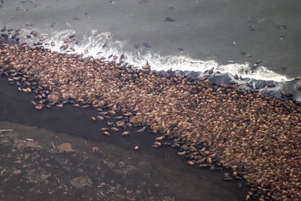
The paper, written by Canadian zoologist Dr Susan Crockford, assesses the recent mass haulouts of walrus females and calves on the beaches of Alaska and Russia bordering the Chukchi Sea. The events have been blamed by US government biologists and WWF activists on lack of summer sea ice, amplified into alarming scare stories by news media around the world.

Such claims ignore previous haulouts that suggest a different cause. Scientific reports about large walrus haulouts that have occurred repeatedly over the last 45 years show that they are not new phenomena for this region.

At least two documented incidents of similar magnitude have occurred in the recent past: one in 1978, on eastern St. Lawrence Island and the other in 1972, on the western end of Wrangel Island. The 1978 event involved an estimated total of almost 150,000 walrus hauled out within in a small geographic area.

Moreover, sea ice maps for the months when known mass haulouts occurred, compared to years when they did not, suggest no strong correlation with low sea ice levels.

“The WWF and American walrus biologists have categorically linked the Point Lay mass haulout event to global warming, but available evidence suggests that’s alarmist nonsense,” Dr Crockford said.

“Blaming lack of sea ice for recent events ignores the documented factor – large population size – that drove walruses onto beaches en masse in the past, when plenty of ice was available. Conservation measures have almost certainly led to a spectacular recovery of walrus numbers over the last few years. This suggests that recent mass haulouts are more an indicator that Chukchi walrus are nearing maximum capacity than a sign of impending global warming catastrophe,” Dr Crockford added.

Here’s the paper. [Link fixed, h/t HO]

Save

Where have all the walrus gone?

Yes, I wondered too. After all the kerfuffle at the beginning of the month there’s been rather dead silence [see my last post here]. So I Googled and found some tidbits.

Chukchi Sea walrus, June 2014. US Fish and Wildlife Service.

Chukchi Sea walrus, June 2014. US Fish and Wildlife Service.

An article a few days ago at one media outlet (October 8, 2014) asked someone from the WWF what happened to the ~35,000 females and calves onshore near Point Lay, Alaska — because really, who else would you ask? Or, perhaps more to the point, would anyone at USGS be expected to answer?

And one online media outlet found walrus specialists in Alaska unwilling to lay all the blame for the recent massive haulout at Point Lay at the feet of low Arctic ice levels due to global warming. See what you think.

UPDATE added below October 13, 2014
Continue reading

Tracking polar bears in the Beaufort Sea – September 2014 map

Here is the September 2014 follow-up to my post on the July 2013 track map for female polar bears being followed by satellite in the Beaufort Sea by the US Geological Survey (USGS) – “Ten out of ten polar bears being tracked this summer in the Beaufort Sea are on the ice.”

See that post for methods and other background on this topic, and some track maps from 2012 (also available at the USGS website here).

The USGS track map for September 2014 is copied below (Fig. 1).

At the end of September, with sea ice starting to rebuild, it appears there were 8 bears on the ice and three on land.

The situation for September was not very much different from August, except that two of the 11 bears (up from one) were on the ice in the Chukchi Sea in September, a phenomenon that was recently acknowledged to have affected the last population estimate for the Southern Beaufort subpopulation.

Continue reading

Tracking polar bears in the Beaufort Sea – August 2014 map

Here is the August 2014 follow-up to my post on the July 2013 track map for female polar bears being followed by satellite in the Beaufort Sea by the US Geological Survey (USGS) – “Ten out of ten polar bears being tracked this summer in the Beaufort Sea are on the ice.”

See that post for methods and other background on this topic, and some track maps from 2012 (also available at the USGS website here).

The USGS track map for August 2014 is copied below (Fig. 1).

Compare this to July’s map (Fig. 4). The 20 bears from May (down to 13 in June) are now down to 11. All seven of the bears outfitted with glue-on satellite transmitters in April [either males or subadult animals] have either moved out of the area or their tags have fallen off or stopped transmitting. This means that all of the bears shown on the maps below are females.

At the end of August, nearing the minimum extent of ice for this year, seven bears were on the ice and only four were on land.
Continue reading

Summer sea ice melt and polar bear maternity dens

The yearly sea ice minimum extent is almost upon us, which has recently been the seasonal signal for excitable biologists and their activist groupies to resume their breathless rants about what sea ice loss could mean for polar bears.

Polar bear den_CreditUSFWS_labeled

Never mind that the summer minimum extent reached in September, no matter how low it goes, is pretty much irrelevant to polar bear health and survival. As I’ve discussed before, what’s really important is the presence of not-too-thick ice during the spring, so they can catch lots of young seals and put on lots of fat.

But to a lesser degree, the extent at mid-to-late summer is important because this is when pregnant females that prefer to make their maternity dens on shore are looking for good places to spend the winter.

So the topic for today is this: how much does the extent of ice at the height of summer dictate where polar bear females make their winter dens?
Continue reading

Tracking polar bears in the Beaufort Sea – July 2014 map and subpopulation boundary issues

Here is the July 2014 follow-up to my post on the July 2013 track map for female polar bears being followed by satellite in the Beaufort Sea by the US Geological Survey (USGS) – “Ten out of ten polar bears being tracked this summer in the Beaufort Sea are on the ice.”

See that post for methods and other background on this topic, and some track maps from 2012 (also available at the USGS website here).

The USGS track map July 2004 is copied below (Fig. 1).

Compare this to June’s map (Fig. 4). The 20 bears from May (down to 14 in June) are now down to 13. All seven of the bears outfitted with glue-on satellite transmitters in April [either males or subadult animals] have either moved out of the area or their tags have fallen off or stopped transmitting. This means that all of the bears shown on the June and July maps below are females.

One bear has moved into Canadian territory and another is well into the Chukchi Sea. This is now known to be a typical rather than unusual phenomenon, and is pertinent to the bigger picture of what constitutes a discrete geographic subpopulation for polar bears.
Continue reading

Counting bears from space can be just as accurate as by helicopter, claims new study

Satellites images might be able to replace aerial counts of polar bears in some places — if there are no clouds. But it seldom distinguishes cubs and can’t tell males from females, found a 2012 study of Foxe Basin bears that’s just been published.

Foxe Basin polar_bears_rowley_island_Stapleton 2012 press photo labeled sm

Note: This is my 200th post since July 26, 2012!

Continue reading

Tracking polar bears in the Beaufort Sea: June 2014 map

Here is the June 2014 follow-up to my post on the July 2013 track map for female polar bears being followed by satellite in the Beaufort Sea by the US Geological Survey (USGS) – “Ten out of ten polar bears being tracked this summer in the Beaufort Sea are on the ice.”

See that post for methods and other background on this topic, and some track maps from 2012 (also available at the USGS website here).

The USGS track map for June 2004 is copied below (Fig. 1).

Compare this to May’s map (Fig. 2) – the 20 bears from last month are down to 14, and all seven of the bears outfitted with glue-on satellite transmitters in April [either males or subadult animals] have either moved out of the area or their tags have fallen off or stopped transmitting. This means that all of the bears shown on the June map below are females with satellite radio collars.
Continue reading

Swimming bear video used for propaganda was not shot with bear-mounted cameras

I just went back to Andy Revkin’s blog post on the swimming polar bear video story that I wrote about on Wednesday to see what kind of feedback it was getting. I found that it pays to check up.

pbear_swimming_USGS

A reader from Oregon questioned the filming techniques used for this video.

Revkin followed up.

And it turned out, the reader from Oregon was correct — the film used in this video was shot with “an assortment of traditional methods,not with the strapped on cameras that the USGS were using on the bears.

Revkin assumed from the background provided to him that this was leading-edge technology, bear-generated video. And even though he’d interviewed the filmmaker, the truth hadn’t come out.

Update June 29, 2014 – another damning comment made, added below.

Continue reading

Swimming bear video used to promote climate change threat to polar bears

A video being hyped around the internet – “Witness a polar bear’s heartbreaking swim for ice in the Arctic” said one headline – is simply shameless propaganda, facilitated by the US Geological Survey and its polar bear biologists. USGS scientists involved in this work should be ashamed of themselves.

The caption for the Youtube video (published Jun 21, 2014) says this:

Take a swim with a polar bear family as they traverse the Arctic Ocean in search of sea ice.

This is a load of nonsense and a total misrepresentation of the facts.

In addition, the text added to the video is pure propaganda: it is being used to promote the US government position that sea ice loss due to climate change is a massive threat to polar bears. Unfortunately, recent studies contradict the contention that polar bears have already been harmed by declines in summer sea ice.

Here are some background to the video you should be aware of:

1) The bears were swimming away from the USGS researchers and film crew who had shot them full of sedatives and attached a camera to one of their necks — they were not swimming toward sea ice 100 miles away.

2) The video was shot in the Bering Sea, in April 2014, when sea ice was about its maximum extent of the year — there was lots of ice around when this video was filmed.

3) The company doing the filming is using this video as a fundraiser.

Details below, including a sea ice map for April 2014.

UPDATE June 27, 2014 – see follow-up post here.

Continue reading