Tag Archives: Newfoundland

Hungry polar bear attacks: why my novel “Eaten” is set in early March

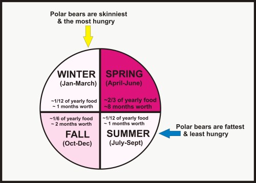
As I’ve pointed out previously, polar bears are leanest – and thus, hungriest and potentially the most dangerous to humans – at the end of winter (i.e. March).

Polar bear feeding by season simple_Nov 29 2015

That is why the unexpected prospect of hundreds of lean and hungry polar bears coming ashore in early March hunting available human prey would be a truly terrifying and daunting experience. Such a speculative scenario stands in marked contrast to an actual incident in July that involved a single well-fed bear that attacked a man asleep in a tent because he and his companions had chosen to dismiss the known risk.

Any predatory attack by a polar bear is terrifying but which is potentially the more deadly? One you can reasonably expect (and thus prepare for) or one that comes out of the blue and catches everyone unprepared?
Continue reading

Amazon reviewer said of my new polar bear attack novel: “I couldn’t put it down”

And another emailed me to say of EATEN:

“Your explanation of the relationship of seals, bears and ice was a treat. Congratulations, “Eaten” is a real page turner.”

EATEN_cover full sm

Update: The review referred to in the title is from the UK store, which has not (a.m. 8 December) been added to the Amazon.com site.

The perfect gift for those fiction readers on your list that love a good scary story. Speculative fiction of the horrifying kind – it could happen, it just hasn’t yet.

Find the paperback at Amazon  and Barnes & Noble

Amazon Kindle ebook

Barnes & Noble NOOK ebook

Kobo bookstore ebooks

Apple device ebook (via iTunes, under “Suspense and Mystery”)

Overdrive ebooks for libraries (see if your library has it: if not, suggest they get it).

Spring sea ice prediction for next year off Newfoundland: extensive ice coverage

EATEN – my new polar bear attack novel – is set in Newfoundland 2025 for a reason. I wondered: what if sea ice coverage 10 years from now is as high or higher than it has been for the last two years, with inevitable positive effects on Davis Strait harp seal and polar bear populations?

The Canadian Ice Service prediction for this region, released earlier this week (1 December 2015, see references for link), is that 2016 is set to meet my “what-if” scenario handily. Nine years to go! See the CIS expected ice coverage for 19 February 2016 below (CIS fig. 3):

2016 Newfoundland Ice outlook for 19 Feb 2016_at Dec 1 2015

How does the above ice map compare to the last two years? At least as high or higher. Have a look below.

Continue reading

Eaten: A novel, now available

My new novel has been published! The paperback is ready to order and will ship immediately; the ebooks are available for pre-order and will download November 30, 2015.

More detail and links here: www.susancrockford.com

Paperback book or Kindle ebook can be ordered on Amazon.com (US and Canada), click here: http://www.amazon.com/Eaten-novel-Susan-Crockford/dp/151930255X [temporary Kindle link here, until Amazon gets it linked to the paperback: http://www.amazon.com/dp/B0182FUIV0 ]

In the UK, find the paperback here and the Kindle version here.

ePub version (via Smashwords, which ships to Apple, Barnes & Noble, and Kobo), see https://www.smashwords.com/books/view/592875

LIMITED TIME OFFER for the ePub version: November 30, 2015 until December 3, 2015 only

     FREE with promotion code GW98Q (not case-sensitive)

This will make a great Christmas/holiday present for friends and family who don’t read science books – give them an alternative with this great story with a bit of science lite.

Heavy ice in Hudson Bay derails ArcticNet global warming research plans: irony bites

Heavy ice in Hudson Bay derails CCGS Amundsen’s research plans” – just in from the CBC (22 July 2015, via Twitchy). Worst ice in 20 years.

ccgs-pierre-radisson-in-sea-ice_to_Iqaluit_july 17_2015

[original caption for the above photo: “The CCGS Pierre Radisson escorts the oil tanker Havelstern to Iqaluit July 17. Tough ice conditions in area have delayed this summer’s annual resupply, and have now derailed the CCGS Amundsen from its carefully planned summer research program.”]

Worst ice conditions in 20 years force change of plans to icebreaker research program

That would be 1992 they’re talking about, the cold year that everyone blamed on the eruption of Mt. Pinatubo. Unfortunately, there are no good detailed ice maps from 1992 (see previous post here). What’s the excuse this year?

CCGS Amundsen is an icebreaker that is usually released from duty to serve as an Arctic research vessel in the summer. And who’s on board? GEOTRACES 2015 Arctic Expedition out of the University of British Columbia with a plan to study (in part) global warming caused “ocean acidification.” Their short blog post shows a map without ice and not a hint they see the irony of the situation.

Here’s the ice they’re talking about (from the Canadian Ice Service), with the communities mentioned in the study marked:

Sea ice at 22 July 2015, with Inukjuak (EHB) and Iqaliuk, Baffin Island marked. Click to enlarge.

Sea ice at 22 July 2015, with Inukjuak, Eastern Hudson Bay, and Iqaliuk, Baffin Island, marked. CIS map. Click to enlarge.

Continue reading

Polar bear habitat update – sea ice for hunting plentiful in all subpopulation regions

Preferred polar bear habitat is said to be 50% concentration or higher over continental shelves, which describes all but the fringes of sea ice extent today, including Hudson Bay, the Southern Beaufort, and the Barents Sea.

Preferred polar bear habitat 50pc concentration_May 8 2015_PolarBearScience

However, polar bears – excellent swimmers that they are – are quite capable of utilizing areas with 15-50% sea ice concentration if necessary (Durner et al. 2004; Rode et al. 2014:79), especially when prey are plentiful.  This would account for the fact that there are still sightings of polar bears in and around northern Newfoundland (see previous post here and photo below1), where ice concentration is in the 30-50% range.

Photo with this news story (7 May 2015): "(Update) Polar bear sighting in Croque"

Photo with this news story (7 May 2015): “(Update) Polar bear sighting in Croque”

Continue reading

Polar bear season for Newfoundland residents still going strong, recent sightings confirm

Two recent sightings of polar bears along the north shore of Newfoundland are a reminder that sea ice is still a prominent feature of the Davis Strait polar bear subpopulation landscape at this time of year.

LaScie_Newfoundland_April 27 2015_ColleenGray label

A polar bear was sighted in the community of La Scie, northern Newfoundland Monday, 27 April (pictured above, swimming in the harbour), while another landed in the town of Fogo, on Fogo Island, last week (see maps below).
Continue reading

Melt season update – Bering Sea ice abundant & Davis Strait ice 2nd highest since 1971

Polar bear habitat in the eastern Bering Sea has expanded since the official spring “maximum extent” was called for late February, and Davis Strait sea ice is tied for 2nd highest since 1971 for this week. Both regions have healthy polar bear populations and spring conditions suggest this will continue into this year.

Rode and Regehr 2010_Chukchi_report2010_Fig1_triplets_labelled

Although the melt season is underway, as of yesterday (22 April, Julian day 112) overall Arctic sea ice extent (Fig. 1) was higher than it was on the same date in 2014, 2007, and 2004 (see also Fig. 2). Despite the record low extent in February (Fig. 3), that pessimists at Polar Bears International suggested was relevant to polar bear heath and survival, I showed that was misleading.

Figure 1. Sea ice extent at 22 April (Julian day 112) for 2015, at 13.976 mkm2, was well within 2 standard deviations and higher than 2007 (shown) as well as 2004 and 2014 (not shown – see it for yourself here).

Figure 1. Sea ice extent at 22 April (Julian day 112) for 2015, at 13.976 mkm2, was well within 2 standard deviations and higher than 2007 (shown), as well as higher than 2004 and 2014 (not shown – see it for yourself here). Click to enlarge.

Sea ice maps and charts tell the story of current polar bear habitat throughout the Arctic.
Continue reading

Spring ice alarm deflated – 2015 ice now as high as 2014 & Davis Strait highest since 1971

Arctic ice extent (at 14.1mkm2) on 15 April, was virtually identical to 2014 on that date, and higher than 2006. But the record goes to Davis Strait, which recorded the highest ice extent since 1971 for the week of April 16, while the waters of Eastern Newfoundland to the south (where most harp seals have their pups) had the third highest ice extent since 1969. Lots of fat baby seals are just what polar bears need at this time of year.

Harp seal pup_DFO Newfoundland

Continue reading

Polar bear habitat update – even more ice this week in the Barents Sea

Polar bear habitat is close to average for this date all over the Arctic this week. Barents Sea pack ice has increased substantially since last week and the ice in Eastern Canada is still well above average (and higher than 1979-early 1980s). Arctic ice has grown since a preemptive call for “the lowest maximum extent on record” was made by NSIDC last week — there is now at least as much ice for this date as there was in 2011 and almost as much as there was last year (2014).

Polar Bear Breaks Ice

Southern Davis Strait polar bears are out feeding on the glut of harp seals in the pack ice off Labrador and Newfoundland (discussed in detail here). One or more bears strayed a bit from the pack and ended up swimming around near the Hibernia oil platform (not far from the ice edge, although the CBC reports didn’t mention that “minor” fact), discussed in this recently updated post (with maps).

Harp seal female with nursing pup, DFO Canada.

Harp seal female with nursing pup, DFO Canada.

Ice maps and graphs below: it’s worth a look.
Continue reading