Tag Archives: breakup

Well-fed polar bears onshore at height of summer easily deterred by noise, CBC reports

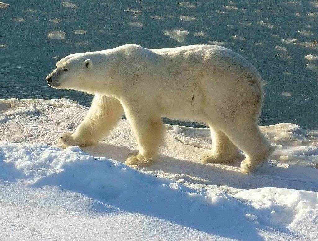
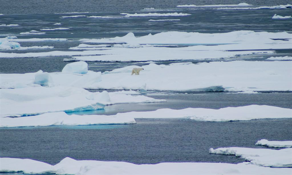
From the CBC this morning, we have the report of a female polar bear and her cub paying a visit to an Nunavut campsite near Chesterfield Inlet in northwestern Hudson Bay, which is technically within the boundary of the Foxe Basin polar bear subpopulation.

Maggie Putulik photo, 29 July 2015 Chesterfield Inlet, Nunavut.

Maggie Putulik photo, 29 July 2015 Chesterfield Inlet, Nunavut.

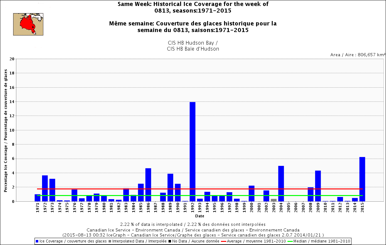
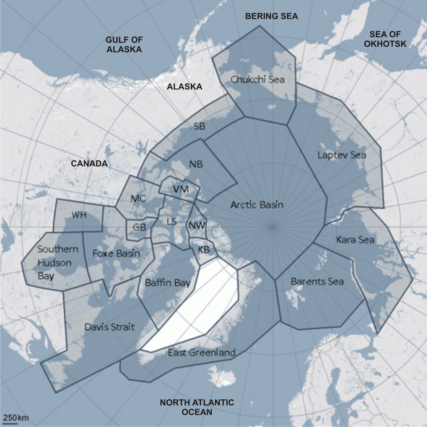
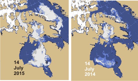
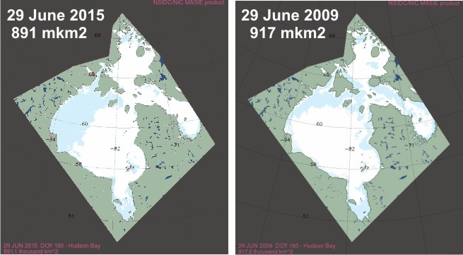
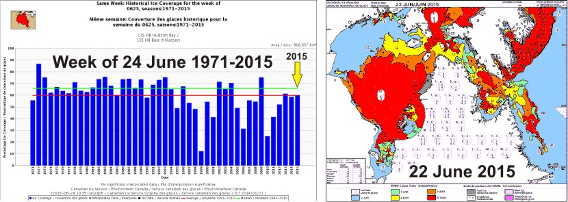
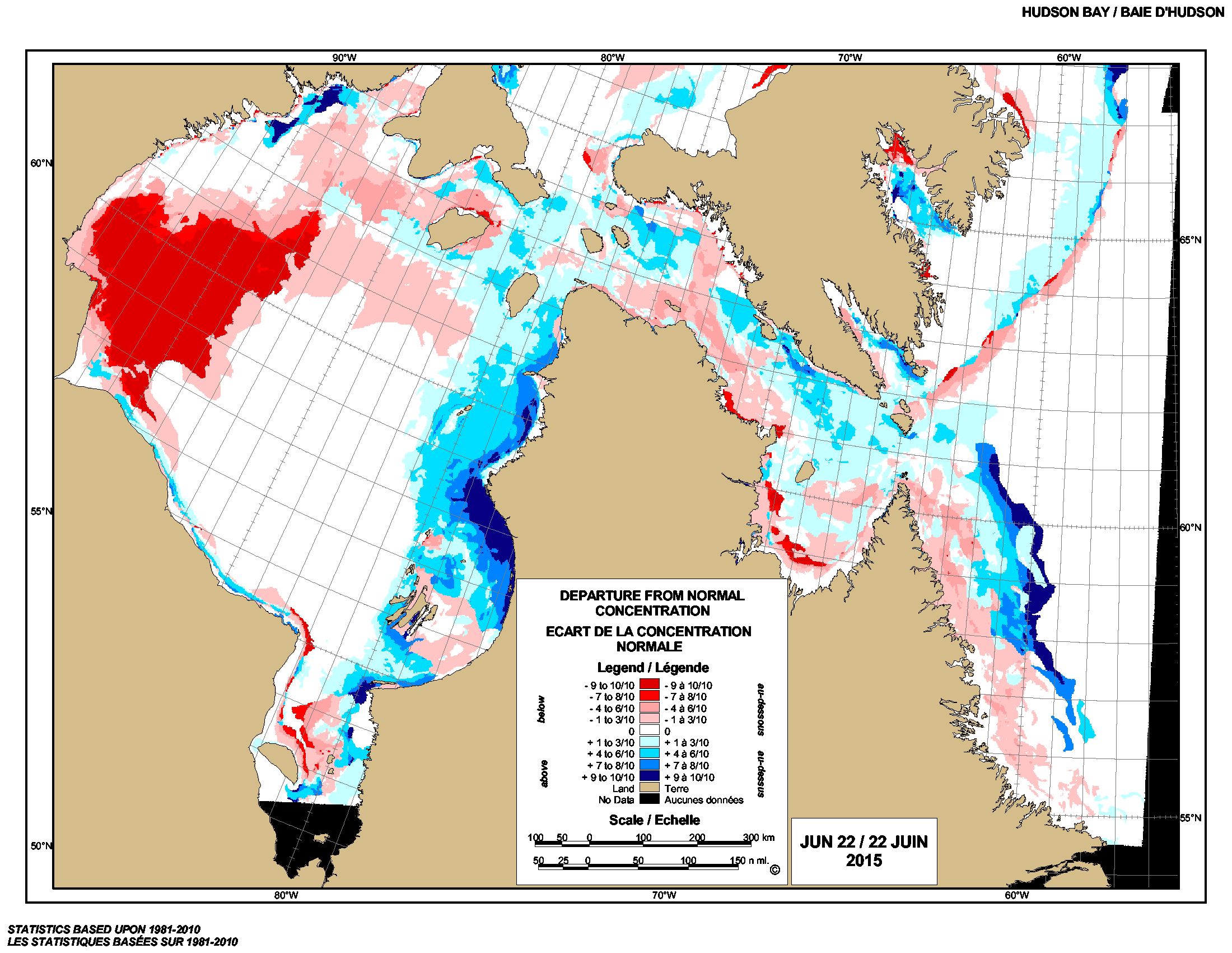
These are not the desperate bear victims of global warming we have been warned about by polar bear specialists but well-fed curious ursids not averse to an easy meal if there’s one to be had. Such bears are easily deterred by a loud noise. Note this was the second visit by polar bears this Nunavut family had experienced at this location within a three-week period – two other bears had stopped by earlier. Note that ice in this region of Hudson Bay broke up earlier than usual this year yet these bears seem to be in fine condition and can expect the first fall ice of the season (freeze-up) to appear in their neighbourhood, see maps below.
Continue reading

2nd highest ice coverage for Hudson Bay since 1971 at mid-August – only 1992 higher

Since 1971, there has been no year when there was as much ice left on Hudson Bay as there is this year at August 13th, except 1992 – the year when Mt. Pinatubo seemingly affected Hudson Bay ice levels but not any other region in Eastern Canada or the Beaufort Sea. Odd, that – see the graphs below.

Hudson Bay same week 13 Aug 1971-2015

Doesn’t mean that much to polar bears, since they will mostly be fasting whether they are onshore for the summer or riding the ice – they primarily live off their fat this time of year. Still, the relative ice levels are interesting because it could impact freeze-up dates later this fall, which will influence the bears’ ability to hunt before the winter fast sets in.

Continue reading

Hudson Bay ice update – researchers awfully quiet about what polar bears are doing

This year 225 thousand km2 of sea ice remained on Hudson Bay at 10 August compared to 96 thousand km2 in 2009, the last late breakup year for which there are detailed ice maps and polar bear data.

Hudson Bay breakup Aug 10 2015_CIS

In 2009, most Western Hudson Bay polar bears were onshore by 22 August, just after the very last remnants of ice disappeared (see map below). This year? The remaining ice is further east, in Southern Hudson Bay territory.  Last report from a few weeks ago showed some Southern Hudson Bay bears came ashore early but past behavior suggests some bears will wait until the bitter end before they come ashore – until the very last remnants of ice disappear (Cherry et al. 2013).
Continue reading

Keeping track of problem bears in Churchill

The City of Churchill has recently taken to posting its problem bear reports on its Facebook page. This is something to keep an eye on, so let’s catch up so that future reports can be put into context.

Figure 1. A bear is transported to Churchill’s polar bear holding facility, from a 2011 Huffington Post article “Polar Bear Prison.”

Photo above:  A bear is transported to Churchill’s polar bear holding facility (from a 2011 Huffington Post article, “Polar Bear Prison”).

Continue reading

Hudson Bay, Davis Strait and Foxe Basin sea ice highest since 1992

We are seeing one of the extremes in Hudson Bay sea ice variability this year, not only in extent but in distribution of ice. Ice coverage on Hudson Bay this year at 28 July was twice what it was in 2009, the last “late” ice breakup year for which detailed ice maps are available (409 vs. 204 thousand km2), according to NSIDC MASIE ice maps. Canadian Ice Service data show 2015 coverage for the week of 30 July was the highest since 1992.

Churchill_Polar_Bear_2004-11-15 Wikipedia

The odd pattern of ice distribution presents a conundrum. Have a look at the maps and graphs below.

Continue reading

Polar bear habitat looking good for early summer – last days before the fast

Some polar bears may already be living mostly off the fat put on over the spring but others may catch a seal or two on the sea ice before the summer fast begins – since the ice hasn’t left the coast in most regions quite yet. Polar bears eat little in summer, whether they spend their time on land or on the sea ice.

PolarBearCV1LG_USGS

Sea ice is still high over Hudson Bay – for this time of year, it hasn’t had this much polar bear habitat since 2009. Davis Strait and Foxe Basin are also above average – Davis Strait hasn’t had this much ice since 1992 (the Mt. Pinatubo cold year). Polar bear subpopulation refresher map below.

PB map-all-populations PBSG original plus Okhotsk
Continue reading

It’s the middle of July – do researchers know where their Hudson Bay polar bears are?

If so, they’re not saying. This year, with higher-than-average sea ice, we’ve heard much less than usual about the location of tagged Hudson Bay polar bears. Odd, isn’t it?

Hudson Bay breakup 2015_2014_14 July

By this time last year, Polar Bears International rep Alysa McCall had published two reports on the location WHB polar bears tagged by the University of Alberta research team led by Andrew Derocher (Fig. 1 below).

Figure 1. Sea ice coverage and locations of female polar bears with tracking collars for 30 June 2014 and 8 July 2014 (black, Western Hudson Bay bears; blue, Southern Hudson Bay bears), courtesy Alysa McCall, Polar Bears International. Click to enlarge.

Figure 1. Sea ice coverage and locations of female polar bears with tracking collars for 30 June 2014 and 8 July 2014 (black, Western Hudson Bay bears; blue, Southern Hudson Bay bears), courtesy Alysa McCall, Polar Bears International. Click to enlarge.

This year, there’s been nothing: not a single PBI mention of WHB breakup. Derocher tweeted a track map on 6 July (2/9 bears ashore), with no updates since, but PBI’s “Bear Tracker” has not been updated since 2 July. Compare this year’s ice cover on Hudson Bay (and elsewhere in Canada) to last year on this date (14 July): quite a difference.
Continue reading

Sea ice breakup update: high ice coverage just about everywhere, even Hudson Bay

There is still a lot of sea ice in Hudson Bay, Foxe Basin, Davis Strait and Baffin Bay this week – more than average for this date – with slightly less than average in the Beaufort Sea. Past behaviour of Western and Southern Hudson Bay polar bears suggests the mean date that bears come ashore for the summer this year will be later than average due to the plentiful ice available, regardless of when polar bear biologists decide that “breakup” has occurred.

Hudson Bay breakup July 8 2015_CIS

Hudson Bay, with almost 50% of the bay still covered in ice, has the third highest coverage this week since 1992 (after 2009 and 2004); Davis Strait has the highest coverage since 1992; and Foxe Basin and Baffin Bay have the highest coverage since 1998. For this week, the Beaufort Sea has the second highest coverage since 2006 (after 2013), and more ice than was present in 1971, 1982, 1987, 1988 and 1998 – among others.

Published data shows that most polar bears of Western Hudson Bay traditionally come ashore in July, but this year it might be late July or even August. Have a look at the charts below.
Continue reading

Hudson Bay breakup later than average, longer hunting season for polar bears

Due to the atypical pattern of sea ice melt on Hudson Bay this year, 2015 will definitely be a later than average breakup year – perhaps not as late as 1992 but maybe almost as late as 2009. Easing into the first days of Arctic summer, there is still a lot of polar bear habitat left on Hudson Bay, especially in the east.

Hudson Bay breakup 2015 vs 2009 at 29 June_MASIE

Although official breakup in 2009 was only a little later than usual (9 July), bears came ashore about the same time (after mid-August) as they did in 1992, when breakup was very late (30 July). With the pattern this year being so unusual (and the melt so slow over the last few weeks), who knows how late it could be before the last bears leave the ice in 2015?

There is definitely more sea ice this year on the bay than there was last year, when breakup was about average for the last 24 years.

UPDATE 2 July 2015: CIS weekly ice coverage graphs added to the end of this post. Hudson Bay ice highest since 2009 and Davis Strait highest since 1994! Have a look.
Continue reading

Polar bear habitat update: many bears on the ice in Hudson Bay, lots of sea ice globally

Polar bear habitat over Hudson Bay was average this week (at 60% coverage), despite the odd pattern of breakup – but the end of spring in the Arctic is only 5 days away and there is still plenty of polar bear habitat in all regions.

Hudson Bay breakup 2015 June 22 and 24_sm

According to the Canadian Ice Service (CIS), there is still more ice in the eastern portion of the bay than usual and much less in the northwest (Fig. 1 below). There is far more ice than average ice in Hudson Strait, the approach to southern Davis Strait.

Figure 1. Hudson Bay sea ice, difference from average at 22 June 2015. Blue is less than average, red is more than average. CIS.

Figure 1. Hudson Bay sea ice, difference from average at 22 June 2015. Blue is less than average, red is more than average. CIS. Click to enlarge.

Continue reading