Category Archives: Life History

Ten out of ten polar bears being tracked this summer in the Beaufort Sea are on the ice

PB_male on ice_Regehr USFWS_March 2010_labeled
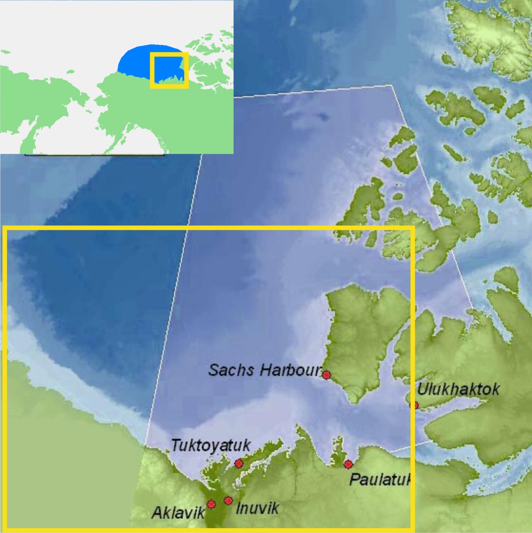
Tracking Beaufort Sea polar bears over the summer — what can it tell us about how important the position of summer sea ice relative to the shoreline in this region is to these bears? Do Beaufort Sea bears get stranded on shore like the polar bears in Davis Strait and Hudson Bay?

Polar bear biologist Eric Regehr (with the US Fish & Wildlife Service, or FWS) has a team working with US Geological Survey researchers (USGS) in the southern Beaufort tracking where adult female polar bears go throughout the year. This is part of on-going research in the Beaufort and Chukchi Sea (see previous post here; see also Fish & Wildlife 2009; Polar Bear News 2010 and 2013; Rode and Regehr 2010, pdfs below; and just out, the “accepted” version of the Rode et al. paper discussed here, and announced in my last post here).

The researchers have been posting a summary map at the end of each month on the USGS website showing the tracks of the females they fitted with radio collars the previous spring — for 2013, and back to 2010. They can’t put collars on male bears because their necks are larger around than their heads, so a collar would just slip off.

I’ve posted the July 2013 track map below, which shows all ten bears out on the ice, and the previous month (June 2013) to compare it to (the August map should be out shortly). I’ve included a few maps from 2012 to allow you to compare this year’s results to the situation last summer.

The August tracks should be available after the Labour Day weekend – check back next week to see where the bears have been this month. I’ll post the map here or you can go to the USGS website directly. [UPDATE Sept 4, 2013: The August map is up, posted here.]

Continue reading

Ian Stirling’s howler update: contradicted by scientific data

Following up on my last post (Ian Stirling’s latest howler: “the polar bear who died of climate change”), I tracked down some details contained in the original Norwegian news report but which were left out of the articles that spread the story around the world. I also found some pertinent research posted online that appears to be the work of the researchers who captured this bear in April.

Figure 1. The Norwegian newpaper, The Local (Aug. 7, 2013), identifies the location that the bear was found as “a small island near Texas Bar” (marked by the square on the above map) in the very north of Spitsbergen and states it was found on July 7 – details other reports did not bother to include. To have been 250km south of that position in April (when he was tagged), he must have left the ice near the southern tip of Spitsbergen when there was still lots of ice further north.

Figure 1. The Norwegian newspaper, The Local (Aug. 7, 2013), says the bear was found on “a small island near Texas Bar” (marked by the square on the above map) in the very north of Spitsbergen, and states it was found on July 7 – details other reports did not bother to include. [“Texas Bar” is a hut built by a Norwegian hunter in 1927]. To have been 250km south of that position in April (when he was tagged), he must have left the ice near the southern tip of Spitsbergen when there was still lots of ice further north.


Continue reading

Biologists spreading misinformation: hybridization with grizzlies not due to polar bears moving inland

A paper published last week in the journal Science, written by a team of biologists and atmospheric scientists, expounds on a possible dire future for a range of Arctic animals. It’s called, “Ecological consequences of sea-ice decline” and surprisingly, polar bears are discussed only briefly.

However, with the inclusion of one short sentence, the paper manages to perpetuate misinformation on grizzly/polar bear hybridization that first appeared in a commentary essay three years ago in Nature  (Kelly et al. 2010)1. The Post et al. 2013 missive contains this astonishing statement (repeated by a Canadian Press news report):

Hybridization between polar bears and grizzly bears may be the result of increasing inland presence of polar bears as a result of a prolonged ice-free season.

Lead author of the paper, Professor of Biology Eric Post, is quoted extensively in the press release issued by his employer (Penn State University, pdf here). In it, Post re-states the above sentence in simpler terms, removing any doubt of its intended interpretation:

“… polar and grizzly bears already have been observed to have hybridized because polar bears now are spending more time on land, where they have contact with grizzlies.

Both statements are patently false. All recent hybridization events documented (2006-2013) occurred because a few male grizzlies traveled over the sea ice into polar bear territory and found themselves a polar bear female to impregnate (see news items here and here, Fig. 1 below). These events did not occur on land during the ice-free season (which is late summer/early fall), but on the sea ice in spring (March-May).

Grizzlies have been documented wandering over the sea ice of the western Arctic since at least 1885 (Doupe et al. 2007; Fig. 2, below) and the presence in this region of hybrid grizzly/polar bear offspring is not an indicator of declining summer sea ice, whether due to global warming or natural causes, or some combination thereof.

Continue reading

Baffin Bay-Davis Strait ice concentration comparison – why use the “summer mean”?

I’ve been in the process of looking at the status of polar bears in the Baffin Bay region, which lies to the north of Davis Strait (Fig. 1), but a related issue caught my attention that I think deserves discussion.

Figure 1. Polar bear subpopulations defined by the Polar Bear Specialist Group (PBSG). Note that Baffin Bay, Davis Strait, Western Hudson Bay and Southern Hudson Bay are all similar in that they become ice-free by early fall (the September minimum) or before.

Figure 1. Polar bear subpopulations defined by the Polar Bear Specialist Group (PBSG). Note that Baffin Bay, Davis Strait, Western Hudson Bay and Southern Hudson Bay are all similar in that they become ice-free by early fall (the September minimum) or even before.

Recall that in a recent post on the Beaufort Sea ice extent comparison offered by the National Snow and Ice Data Center (NSIDC) here, I commented:

What puzzled me was why they featured only the last 7 years when satellite data go back to at least 1979. Is there something in that data they don’t want us to see?”

Something similar struck me about the analysis of sea ice in Baffin Bay and Davis Strait conducted by polar bear researchers Karyn Rode and colleagues (Rode et al. 2012). In their comparison of body condition (relative fatness) of bears in Davis Strait and Baffin Bay (see previous post here), they introduced an entirely new sea ice metric – “mean daily summer sea ice concentration,” defined as the mean of values between May 15 and October 15 each year based on ice charts provided by the Canadian Ice Service.

Why invent a metric that has never been used (as far as I know) for analysis of polar bear health, survival or success?

Why not use breakup dates, as has been done for decades for subpopulations in Hudson Bay (e.g. Cherry et al. 2013), where the ice also disappears in late summer?

Is there something in the ice data for Baffin Bay and Davis Strait that Rode and colleagues don’t want us to see?

Since I had already made a composite of Cryosphere Today ice maps at July 12 for my discussion of the Chukchi/Beaufort NSIDC analysis mentioned above, it was relatively easy to look at what was going on in Baffin Bay and Davis Strait on that date in mid-summer. Keep in mind that ice extent and concentration at July 12 records the state of polar bear habitat prior to the late summer decline in sea ice that occurs every year.

Continue reading

Chukchi/Bering Sea ringed seals doing better despite declines in ice and snow: new study

Ringed seal pup in snow cave

Previously, I highlighted new research results that showed, contrary to expectations, polar bears in the Chukchi Sea subpopulation are doing better – despite declines in extent of September sea ice – since the 1970s. So it might not come as much of a surprise to find that the same is true for the primary prey of polar bears in the Chukchi and Bering Seas, Arctic ringed seals (Phoca hispida hispida).

Surprisingly, less than 6 months after Arctic ringed seals were placed on the American list of “threatened” species (under the ESA, see previous post here), actual research in Alaska has shown that declines in sea ice have proven better for ringed seals, not worse.

At a presentation given at the Lowell Wakefield Fisheries Symposium in March (Anchorage, Alaska) [program and links to pdfs here] Justin Crawford, a biologist with the Alaska Department of Fish and Game (ADF&G) presented the results of ringed seal research conducted by himself and fellow ADF&G biologist Lori Quakenbush in the Chukchi and Bering Seas (posted online by the event organizers, see references below).

As for polar bears, the Crawford and Quakenbush presentation provides some very interesting details on the status of Chukchi and Bering Sea ringed seals over the last 40 years, and contains some mighty “inconvenient” conclusions that should raise some eyebrows.

I’ve summarized these details and conclusions below in point form, with a map.
Continue reading

Good news for polar bears: no early breakup of W. Hudson Bay sea ice this year

The sea ice chart provided by the Canadian Ice Service (Fig. 1 below) shows a lot of ice still present in Hudson Bay today, the last day of June, 2013.

Figure 1. Sea ice extent in Canada, June 30, 2013. From the Canadian Ice Service.

Figure 1. Sea ice extent in Canada, June 30, 2013. From the Canadian Ice Service.

This means we have long passed the point when breakup of the sea ice in Western Hudson Bay (30% ice concentration) could be considered ‘early.’ See Table 1 below for previous breakup dates (1991-2009) and previous post here for more details.

 Table 1. Breakup dates calculated for Western Hudson Bay, 1991-2009, using a new method described by Cherry et al. (in press). More details in previous post here.


Table 1. Breakup dates calculated for Western Hudson Bay, 1991-2009, using the new method described by Cherry et al. (2013, in press). More details in previous post here.

Since most polar bears don’t leave the ice until almost a month after the official breakup date is declared, it means that even if breakup for Western Hudson Bay occurs within the next few days, most polar bears would not start their summer fast until the beginning of August.

Regardless of when polar bear biologists decide that breakup has occurred, one thing is now clear — this will not be an early breakup year for Western Hudson Bay. That’s good news for polar bears.

And what about the rest of the Arctic? You’ll see from Fig. 2 below that as of yesterday (June 29), there was still ice present in each of the 19 polar bear subpopulation regions — more good news for polar bears.

Figure 2. Sea ice extent worldwide vs. polar bear subpopulations at June 29, 2013. On this date, there was still sea ice present in every one of the 19 subpopulation regions. Map on the left from US National Snow and Ice Data Center (NSIDC “MASIE”) here; map on the right from the Polar Bear Specialist Group, with labels added. Click to enlarge

Figure 2. Sea ice extent worldwide vs. polar bear subpopulations at June 29, 2013. On this date, there was still sea ice present in every one of the 19 subpopulation regions. Map on the left from US National Snow and Ice Data Center (NSIDC “MASIE”) here; map on the right from the Polar Bear Specialist Group, with labels added. Click to enlarge

References
Cherry, S.G., Derocher, A.E., Thiemann, G.W., Lunn, N.J. 2013. Migration phenology and seasonal fidelity of an Arctic marine predator in relation to sea ice dynamics. Journal of Animal Ecology 82(4):912-921.
http://onlinelibrary.wiley.com/doi/10.1111/1365-2656.12050/abstract

Why is it that every decade, Eastern Beaufort sea ice gets really thick?

I’ve written before about the incidents of starving polar bears in the eastern portion of the Southern Beaufort Sea (here, here, and here). For two or three years every decade since the 1960s, shorefast ice in the Eastern Beaufort (Fig. 1) has become too thick and compressed in the spring for ringed seals to maintain their breathing holes, so most or all of them presumably go elsewhere — as seals did in Greenland when ice got too thick there (Vibe 1965). With few or no seal pups born during March and April in thick ice years, some bears had a hard time finding enough food: starving bears and dying cubs were the result.

Figure 1. Eastern portion of the southern Beaufort Sea.  The communities of Tuktoyatuk (locally known as ‘Tuk’), and Sachs Harbour on southern Banks Island, have been useful starting points for polar bear research because they are accessible by plane via the larger community of Inuvik The light blue portions, e.g. along western Banks Island and the Eastern Beaufort/Yukon mainland coast, indicate shallow continental shelf areas (20 km wide in places) where extensive shorefast ice develops every winter. Main map from Beaufort Sea Partnership, inset map from Wikipedia.

Figure 1. ‘Eastern Beaufort’ (yellow square) polar bear study region.
The communities of Tuktoyatuk (locally known as ‘Tuk’), and Sachs Harbour on southern Banks Island have been used as base camps for polar bear research because they are accessible by plane via the larger community of Inuvik.
The light blue portions along western Banks Island and the Eastern Beaufort/Yukon mainland coast indicate shallow continental shelf areas (20 km wide in places) where extensive shorefast ice develops every winter.
Main map from Beaufort Sea Partnership, inset map from Wikipedia.

I’ve been trying to get my head around why this would happen in the Eastern Beaufort. Once or twice – maybe – but several times every decade? What on earth drives such a process?

So, I did some reading (actually, quite a lot of reading) and have what appears to be at least a partial answer.

All indications are that the occasional development of exceptionally thick spring ice in the Eastern Beaufort is the result of an entirely natural, cyclical phenomenon. However, some polar bear biologists are attempting to blame the latest episode (but not earlier ones) on increased amounts of open water in the Chukchi Sea during fall of the early 2000s. That doesn’t seem a plausible explanation to me, given the history of the sea ice in this region. Have a look.

Figure 2. Beaufort sea pressure ridges, spring 1949. Courtesy Wikipedia (from NOAA “At the ends of the Earth” image collection #corp1014).

Figure 2. Beaufort sea pressure ridges, spring 1949. Courtesy Wikipedia (from NOAA’s “At the ends of the Earth” image collection #corp1014).

Continue reading

Sea ice, beluga whales, and polar bear densities in the Gulf of Boothia

As I discussed in my last post, the Gulf of Boothia subpopulation in the central Canadian Arctic has the highest density of polar bears anywhere in the world. The question is, why?

For example, is the sea ice in the Gulf of Boothia region so markedly different from its nearest subpopulation-neighbor, M’Clintock Channel (Fig. 1), that it accounts for the wide disparity in polar bear densities between the two? The differences, remember, are dramatic: Gulf of Boothia, 18.3 bears per 1000 km2 vs. M’Clintock Channel, 1.9. And while M’Clintock Channel may be low in part due to recent over-harvests (see footnote 1), even the density before over-harvests occurred in M’Clintock Channel were only 4.7, compared to 10.4 bears per 1000 km2 in Gulf of Boothia (see Table 1 in previous post).

Today, I’ll take a look at sea ice and ringed seal habitat in the Gulf of Boothia and M’Clintock Channel, as well as information from a study on polar bear diets, which together shine some light on why the Gulf of Boothia is such a great place for polar bears.

Figure 1. Map showing the side-by-side relationship of M’Clintock Channel and the Gulf of Boothia. From Barber and Iacozza (2004: Fig. 1).

Figure 1. Map showing the side-by-side relationship of M’Clintock Channel and the Gulf of Boothia. From Barber and Iacozza (2004: Fig. 1).

Continue reading

Buffet time for polar bears – spring/early summer is for eating baby seals

Spring is the busiest and most important season for polar bears: it is the most important feeding period and it is also when mating occurs. The fat that polar bears put on during the spring and early summer is critical for their survival over the rest of the year and for females, determines whether they can successfully produce cubs the following year.

Mothers and new cubs emerge from their winter dens in late March to early April and those who have chosen to den on land soon head towards the sea ice. For a fabulous photo of a polar bear female and her two young cubs, just out of their winter den, feeding on a bearded seal pup, pop over here. All other bears, including females with older cubs, will already be on the ice, feeding on the first newborn ice seals of the season and any other seals they can catch.

It’s buffet time for polar bears but the most dangerous time for cute baby seals. Continue reading

Not much has changed in polar bear country since the sea ice maximum

I’ve been busy with work-related activities lately and will be for several more weeks. Until then…

Sea ice changes since March 15 [Update added May 10, see below]

Lots of ice everywhere – even in Hudson Bay. A bit less ice in the Barents Sea (north of Norway) than there was two months ago at the sea ice maximum March 15 (see Fig. 1 below compared to the extent at May 5 in Fig. 2: both from NSIDC). But there is still quite a bit around Svalbard – that group of islands between NE Greenland and NW Norway (see Fig. 3 below a MASIE image, where this situation is more apparent).

Polar bears are eating and mating at this time of year (early May being the tail-end of the season in most areas) – and right now, they have a huge, circumpolar ice platform for those activities.

Continue reading