Tag Archives: Derocher

Sea ice breakup update: high ice coverage just about everywhere, even Hudson Bay

There is still a lot of sea ice in Hudson Bay, Foxe Basin, Davis Strait and Baffin Bay this week – more than average for this date – with slightly less than average in the Beaufort Sea. Past behaviour of Western and Southern Hudson Bay polar bears suggests the mean date that bears come ashore for the summer this year will be later than average due to the plentiful ice available, regardless of when polar bear biologists decide that “breakup” has occurred.

Hudson Bay breakup July 8 2015_CIS

Hudson Bay, with almost 50% of the bay still covered in ice, has the third highest coverage this week since 1992 (after 2009 and 2004); Davis Strait has the highest coverage since 1992; and Foxe Basin and Baffin Bay have the highest coverage since 1998. For this week, the Beaufort Sea has the second highest coverage since 2006 (after 2013), and more ice than was present in 1971, 1982, 1987, 1988 and 1998 – among others.

Published data shows that most polar bears of Western Hudson Bay traditionally come ashore in July, but this year it might be late July or even August. Have a look at the charts below.
Continue reading

Polar Bear Science envy – polar bear biologist Andrew Derocher steals my blog name

I’ve got an imitator! It appears that a recently created website promoting polar bear biologist Andrew Derocher’s lab at the University of Alberta just happens to have the same title as my blog: Polar Bear Science.

Derocher lab website title page_July 5 2015

Oscar Wilde said:

Imitation is the sincerest form of flattery that mediocrity can pay to greatness.”

Gosh, I’m seriously chuffed.

From the look of it, Derocher and his students would like to ride on the coattails of my online success and garner some Google-search views for themselves – check my blog stats, lower right: I’m coming up on half a million views in just under three years (since 26 July 2012).

Sadly for them, it does not appear to be working.
Continue reading

Hudson Bay breakup later than average, longer hunting season for polar bears

Due to the atypical pattern of sea ice melt on Hudson Bay this year, 2015 will definitely be a later than average breakup year – perhaps not as late as 1992 but maybe almost as late as 2009. Easing into the first days of Arctic summer, there is still a lot of polar bear habitat left on Hudson Bay, especially in the east.

Hudson Bay breakup 2015 vs 2009 at 29 June_MASIE

Although official breakup in 2009 was only a little later than usual (9 July), bears came ashore about the same time (after mid-August) as they did in 1992, when breakup was very late (30 July). With the pattern this year being so unusual (and the melt so slow over the last few weeks), who knows how late it could be before the last bears leave the ice in 2015?

There is definitely more sea ice this year on the bay than there was last year, when breakup was about average for the last 24 years.

UPDATE 2 July 2015: CIS weekly ice coverage graphs added to the end of this post. Hudson Bay ice highest since 2009 and Davis Strait highest since 1994! Have a look.
Continue reading

Same amount of sea ice for Hudson Bay polar bears as 2013, bears still on the ice

Sea ice coverage for Hudson Bay on 14 June converged on levels recorded in 2013, when breakup was slightly later than the average of the last two decades.

r10_Hudson_Bay_ts

There is also more ice over Hudson Bay than there was in 2011, which was an early breakup year (charts for other Arctic regions here, originals here).

Andrew Derocher notes (via twitter) that rather than heading to shore, most of the Hudson Bay bears with satellite tracking collars (7/10) are out on the ice (Fig. 1 below). They appear to be hunting along the ice edge, where they are most likely to find seals.

Update 17 June 2015: Sea ice images for the week 18 June 2015 compared to other years added below, for Hudson Bay and the Beaufort Sea.

Continue reading

Hudson Bay breakup date for 2015 will really depend on which definition you use

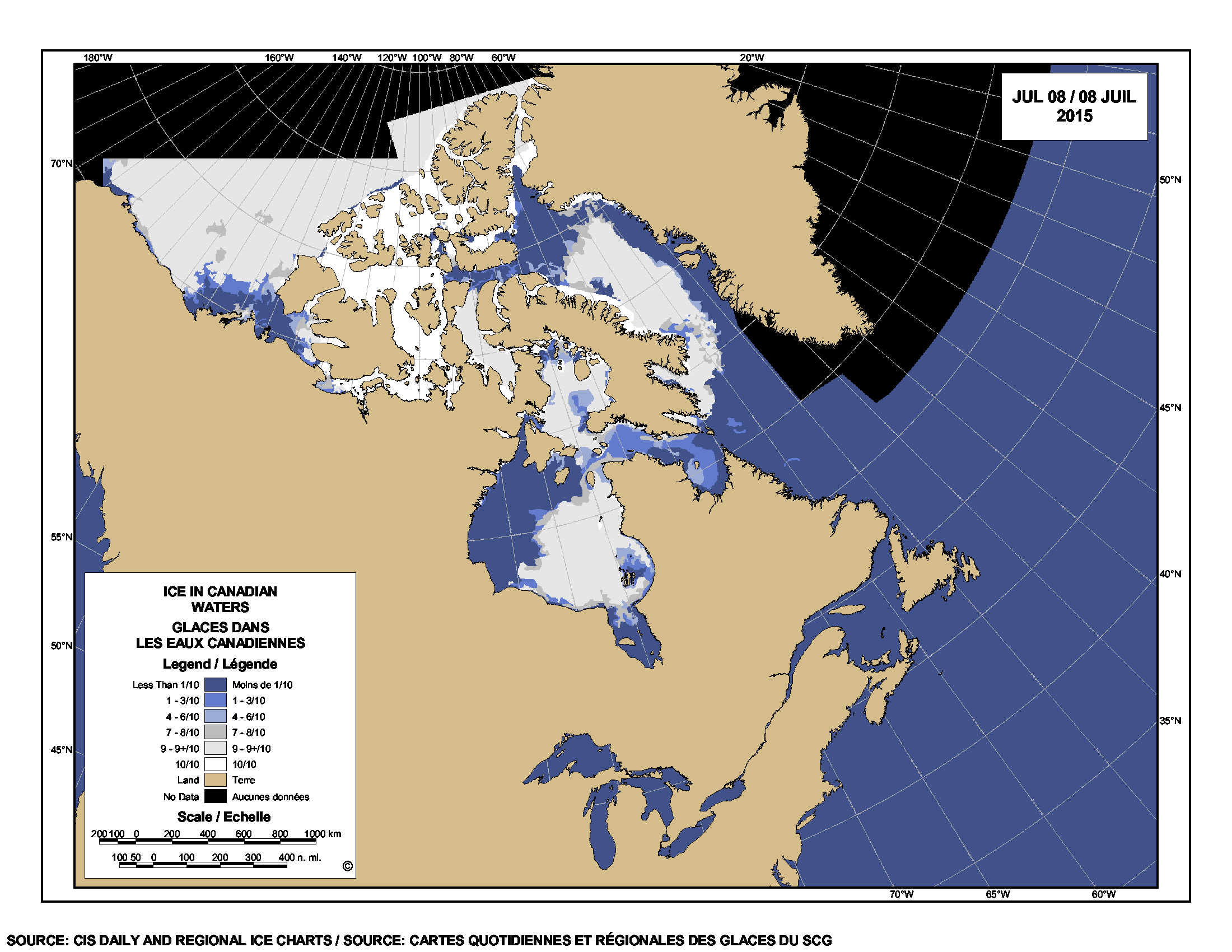
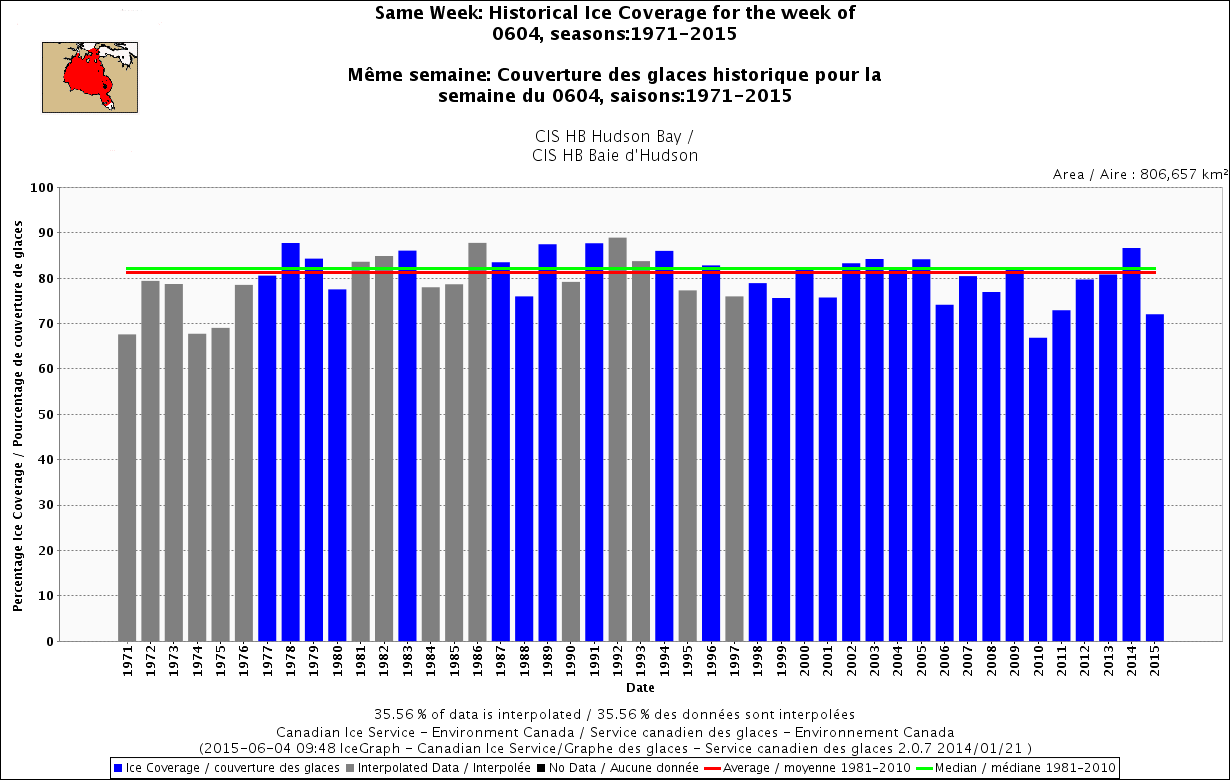
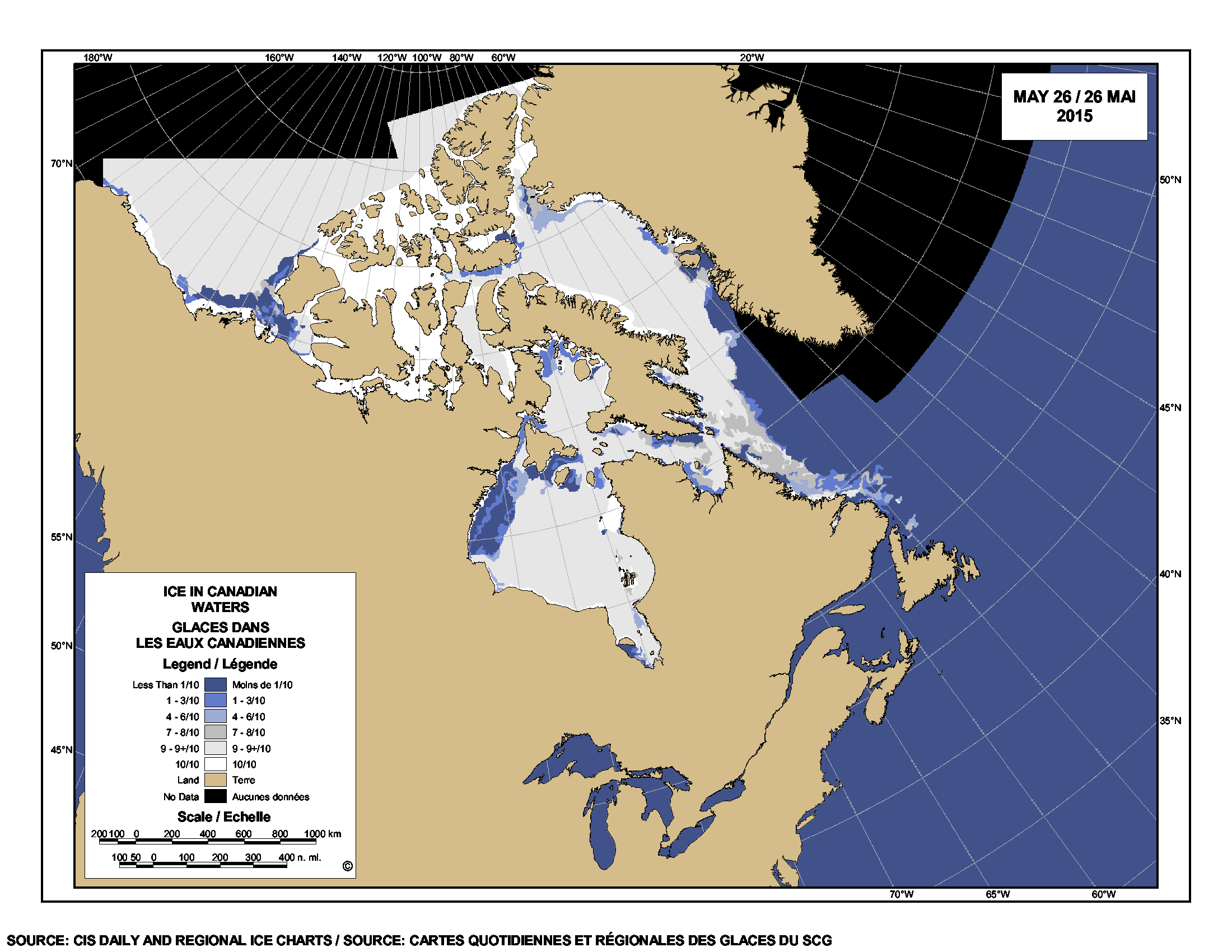
Is breakup imminent for Hudson Bay sea ice? Probably not, but this year more than ever, it will depend on how you define it. Hudson Bay concentratation_2015 June 1_CIS Despite a large patch of open water in western Hudson Bay (CIS chart above, for 1 June), there is still more than 70% sea ice coverage over the entire bay as of this week, when you use the standard breakup definition of 50% ice coverage (Fig. 1).  Ice remaining over the bay is mostly 90% or greater, as the chart above shows – which means there is still a lot of polar bear hunting habitat remaining.

Figure 1.

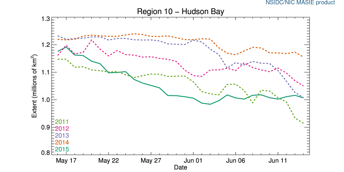
Figure 1. Sea ice coverage over Hudson Bay, as a percentage, for the week of 4 June, 1971-2015. Click to enlarge.

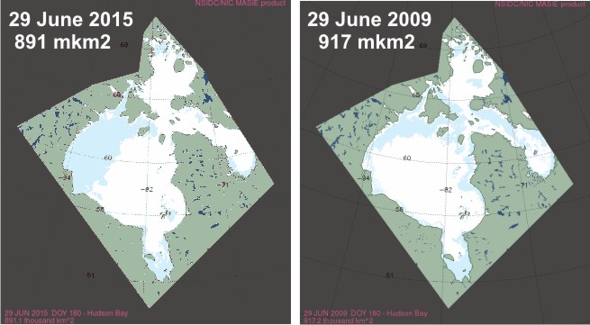
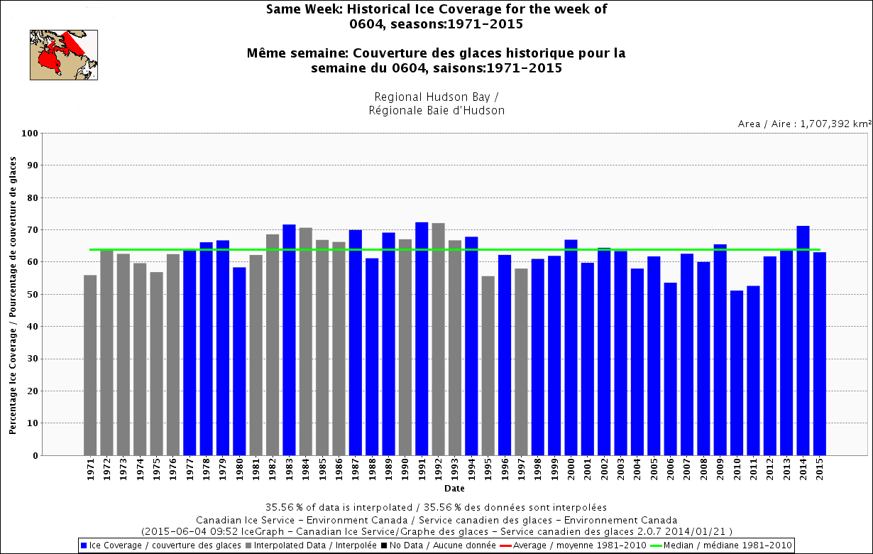
The interconnected region of Hudson Bay, Hudson Strait, and southern Davis Strait (Fig. 2), what the Canadian Ice Service calls “Regional Hudson Bay,” is only slightly below average for the week of 4 June.

Regional Hudson Bay, week of 4 June.

Figure 2. Regional Hudson Bay, week of 4 June. Click to enlarge.

Since ice concentration is factored into breakup date calculation, a record-early breakup is simply not possible, since the previous record date (2 June, for 1990) has already passed. It might be an earlier than average breakup year but not very early, based on the 50% coverage definition (Fig. 3, below). This year, because of the unusual pattern of breakup of Hudson Bay ice, it will be critical for polar bears which definition of breakup is used – the old, 50% method (adopted because it’s what sea ice professionals used) or the newest one, which was determined to be most relevant to WHB polar bears (Cherry et al. 2013).

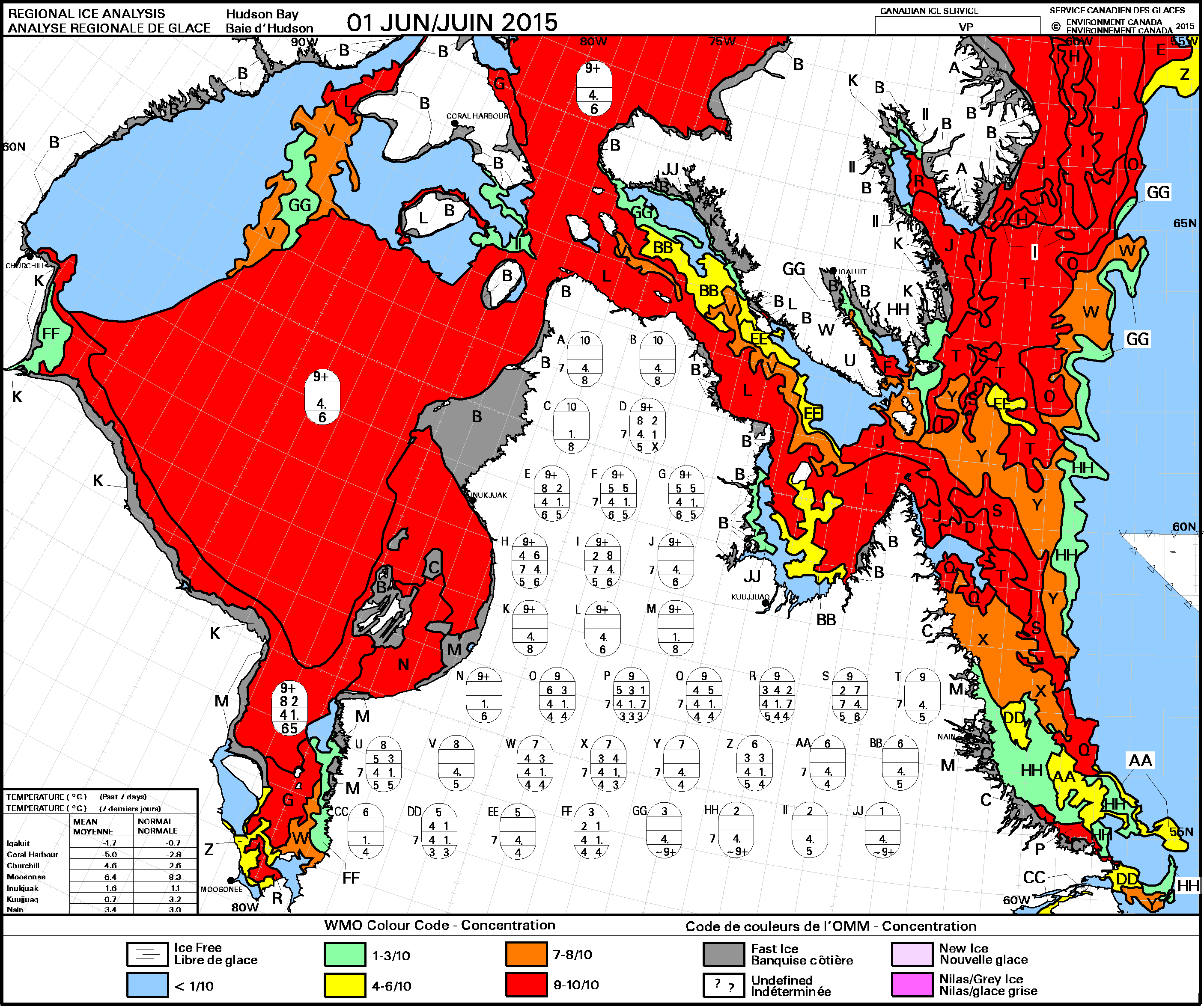
UPDATE 6 June 2015: I’ve added the forecast for ice conditions over the summer for North America (which for these folks includes June because it’s aimed at temperate NA, polar bear folks call June the end of spring), provided by the Canadian Ice Service: “Seasonal outlook for North American Arctic Waters issued by the North American Ice Service on 2 June 2015” [points of potential interest marked] The sea ice forecast (Table 1) for southwestern Hudson Bay (where most western and southern Hudson Bay polar bears come ashore) is for complete ice melt by 1 Aug, eight days later than the earliest date over the period 1968-2013. Time will tell if that’s what happens.
Continue reading

Hudson Bay sea ice coverage is atypical this year but what does that mean for polar bears?

Churchill_Polar_Bear_2004-11-15 Wikipedia

There is a rather large patch of open water in the northwest sector but what’s also unusual about breakup this year is the virtual lack of open water in eastern Hudson Bay – that almost never happens (compare to 2013 here). In addition, there’s still very little open water in Hudson Strait, which connects Hudson Bay to Davis Strait in the east – that’s also unusual.

Figure 1.  Sea ice extent over Hudson Bay and Hudson Strait at 26 May 2015. Canadian Ice Service.

Figure 1. Sea ice extent over Hudson Bay and Hudson Strait at 26 May 2015. Canadian Ice Service. Click to enlarge.

The question is: does the somewhat unusual pattern of ice cover at this date – which developed rapidly over the last few weeks – suggest we can predict whether polar bears will have a shorter-than-average hunting season?

To answer that, you have to look at maps generated by the same source over several years. The result, in my opinion, is inconclusive – while so far, this year looks a bit more like 2009 (which was a very late sea ice breakup year) than it does 2011 (which was an early breakup year), it’s really too early to tell.

I suggest we simply won’t know for another month or so which pattern will prevail. However, that hasn’t stopped IUCN Polar Bear Specialist Group member Andrew Derocher (via Twitter, e.g., here and here, among many others) from suggesting that this year’s pattern is likely a portend of doom for Hudson Bay polar bears. See what you think.
Continue reading

Challenging polar bear fearmongering about Arctic sea ice extent for March 2015

Here are some facts to counter the misinformation and fearmongering being spread via twitter by a polar bear biologist who is getting carried away with his conservation activism.

Arctic Sea ice extent March greater than PB habitat_April 12 2015

Following up on my last post, I note that Arctic regions with sea ice but not polar bears were about 0.32 mkm2 below last year’s March average extent – which means the total ice decline from 2014 (0.4 mkm2) represents only a slight decline in polar bear habitat, most of which is in the Barents Sea (and due primarily to the state of the AMO, not global warming).

Sea ice extent for the Sea of Okhotsk and Baltic Sea combined (both areas without polar bears)1 were about 0.6 mkm2 below average this year for March. Average extent for March (according to NSIDC) is 15.5 mkm2, which means this year’s extent (14.4 mkm2) was 1.1 mkm2 below average, of which less than half (0.5 mkm2) was “lost” polar bear habitat.

IUCN Polar Bear Specialist Group biologist Andrew Derocher has been saying this is a “huge loss for polar bears” (see below): rational analysis of the facts show it is not. Continue reading

Arctic sea ice extent total for March does not equal global polar bear habitat

Only half or less of the estimated 2.6% loss per decade of March sea ice extent since 1979 (Fig. 1, below) represents a decline in polar habitat. That’s because several regions with sea ice that are not home to polar bears, like the Sea of Okhotsk, are included in Arctic sea ice totals.

Figure 1. Average monthly Arctic sea ice extent for March 1979-2015, which includes ice in the Sea of Okhotsk and the Sea of Japan, a decline of 2.6% per decade. NSIDC, March summary 2015.

Figure 1. Average monthly Arctic sea ice extent for March 1979-2015 (which includes ice in the Sea of Okhotsk, the Sea of Japan, and the Baltic, where polar bears do not live), shows a decline of 2.6% per decade. NSIDC, March summary 2015.

Both the Sea of Okhotsk and northern Sea of Japan (Fig. 2) have sea ice in winter (which is included in total Arctic sea ice records) but they are not truly “Arctic” – neither is connected to the Arctic by continuous ice, even when the ice is at its maximum extent (nor is the Baltic Sea — in contrast to Hudson Bay and the east coast of North America, which are connected to the Arctic by continuous ice).

Sea of Okhotsk_1979 March marked_PolarBearScience

Figure 2. Location of the Sea of Okhotsk and Sea of Japan. Insert ice map for March 1979 from NSIDC shows it’s position relative to the Arctic proper.

That lack of connection to Arctic pack ice is probably the main reason that polar bears never colonized the Sea of Okhotsk, even though western Arctic seal species (ringed, bearded, spotted, and ribbon) and Arctic whales  (bowhead and beluga) live there. Polar bears don’t currently live in the Sea of Okhotsk and all evidence suggests they never have.

Sea ice maps show that about half of the total ice extent difference between March 1979 and March 2015 was due to a relatively large decline in sea ice cover for Sea of Okhotsk and northern Sea of Japan — regions without polar bears. Surely no reputable scientist or journalist would suggest that the “record low” maximum ice extent for 2015 has any relevance for polar bear health and survival? [or for Northwest Passage travel, for that matter] Sadly, they would.

Continue reading

Polar bear habitat update – even more ice this week in the Barents Sea

Polar bear habitat is close to average for this date all over the Arctic this week. Barents Sea pack ice has increased substantially since last week and the ice in Eastern Canada is still well above average (and higher than 1979-early 1980s). Arctic ice has grown since a preemptive call for “the lowest maximum extent on record” was made by NSIDC last week — there is now at least as much ice for this date as there was in 2011 and almost as much as there was last year (2014).

Polar Bear Breaks Ice

Southern Davis Strait polar bears are out feeding on the glut of harp seals in the pack ice off Labrador and Newfoundland (discussed in detail here). One or more bears strayed a bit from the pack and ended up swimming around near the Hibernia oil platform (not far from the ice edge, although the CBC reports didn’t mention that “minor” fact), discussed in this recently updated post (with maps).

Harp seal female with nursing pup, DFO Canada.

Harp seal female with nursing pup, DFO Canada.

Ice maps and graphs below: it’s worth a look.
Continue reading

No evidence of actual damage to polar bear brains from environmental contaminants

Earlier this year we had polar bear penis bones supposedly breaking due to environmental toxins; this week we have their brains damaged.

The March 15 ScienceNordic story (“Chemical pollution is causing brain damage in polar bears”) came complete with a photo of a bear (copied below, provided by research co-author Rune Dietz) that is presumably meant to convey what a “brain damaged” polar bear might look like — if not, perhaps another photo would have been a better choice?

Polar bear looking brain damaged Rune Dietz photo Science Nordic

Except, the research only showed there theoretically might be damage but the researchers didn’t bother looking for it before shouting out their findings. All about the scary message, these folks: the very large uncertainties and speculation in their research be damned.
Continue reading