Tag Archives: sea ice

New paper shows no harm from more time on land for S. Beaufort polar bears

polarbears-arcticnatlwildliferefuge-suzannemiller-usfws_labeled_smTake-home quote from a new polar bear paper by Todd Atwood and colleagues (2016):

“…there is no causal link between the patterns in polar bear vital rates and increased use of terrestrial habitat…”

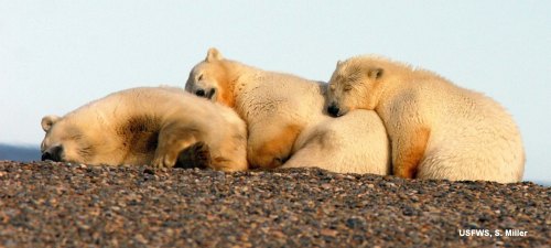
In other words, there was no information to link the increased time polar bears spent onshore with either an increase or a decrease in body condition, survival or cub production. The authors did find that polar bears were strongly attracted to the bone piles that accumulated in the fall from 2010-2013 after Inuit bowhead whale (Balaena mysticetus) hunting at Barrow, Cross Island, and Kaktovik. Isn’t that a surprise?

The results also appear to confirm previous work that showed terrestrial (land-based) foods are not important to polar bears – a conclusion I totally agree with and which I discussed last year here. No wonder there was no press release issued by USGS about this study. It’s only “news” because someone the Anchorage Daily News interviewed lead-author Atwood yesterday as a way of promoting the International Bear Conference (see previous post here, now updated with a link to the Talk of Alaska radio podcast). Atwood implied there could be advantages to bears from feeding on the bone piles but admitted he had no data to support that assumption.
Continue reading

Ice maps vs. observations in the W. Arctic – polar bear habitat reality check

Last Wednesday (8 June 2016), the US Coast Guard rescued walrus hunters from Shishmaref in the Bering Strait who got stuck in sea ice that is barely visible on sea ice maps. It’s a rare glimpse of what sea ice really looks like up close compared to what you see on the ice maps.

Watch the video here: https://www.dvidshub.net/video/embed/467959

[Unfortunately, the screencaps from the video, like the one below, are less impressive than the film. In the video, you can see the hunters walking on the ice around their trapped boat – the ice does not visibly move]

Shishmaref_ice_CoastGuard 02_8 June 2016

Have a look at the sea ice maps below for the day the incident took place. They show what appears to be hardly any ice in the area.

This is a good lesson for assessing what’s been going on in the Beaufort Sea a bit further east, where winds and currents have opened up a rather large patch of open water surrounded by considerable expanses of sea ice – at issue is the possible impact on polar bear spring feeding for April and May.
Continue reading

Some inconvenient polar bear facts supported by scientific literature

The evidence that polar bears have not been harmed by recent declines in sea ice is contained in the scientific literature, no matter what some researchers say when they talk to the media.

USGS w_polarbearscience_caption 2016

Here’s a few of those facts (not all, by any means), with the references to back them up:
Continue reading

Colleague says EATEN possibly a real service to polar bear conservation

My last post, on the up-coming International Bear Conference in Anchorage, presents the perfect backdrop for highlighting a wonderfully unbiased review of my polar bear attack thriller, EATEN, penned by a prominent Canadian polar bear researcher who is utterly convinced that future sea ice loss is the biggest threat to the species (and a former student of the grand-daddy of all polar bear researchers, Ian Stirling).

June summer reading sale image3

Here is what polar bear-human interaction specialist Douglas Clark had to say about my novel in his Amazon review (note I did not send Doug a review copy because he did not request one – he bought it himself – so I had no idea this was coming):

Thought-provoking, and possibly a real service to polar bear conservation

His detailed thoughts on the book below.
Continue reading

Tracking polar bears in the Beaufort Sea and the issue of open water in May

A map posted by USGS shows that the 13 polar bears with tags or collars tracked during April 2016 in the Beaufort Sea were down to 9 in May (7 females with collars, 2 subadult or adult males with tags). As two rather large patches of open water formed last month in the Beaufort – mostly due to winds and currents, rather than melt (see animation below, original post here) – a reasonable question is this: how have polar bears dealt with this somewhat unusual condition?

Polar_Bear_Biologist_USFWS_working_with_a_Bear_Oct 24 2001 Amstrup photo

Beaufort Sea breakup in April due to the effects of the Beaufort Gyre (NASA video):

There is also fairly extensive open water in Hudson Bay, so the same question can be asked for that region as well – but fortunately, we have data on tagged bears from both regions to give us a clue as to how the bears are faring.
Continue reading

Another alleged grizzly-polar bear hybrid shot but it’s not a sign of climate change

CBC News this morning (“Grolar or pizzly? Experts say rare grizzly-polar bear hybrid shot in Nunavut: Expert says interbreeding may be happening more frequently due to climate change“) suggests that a putative grizzly x polar bear hybrid bear shot outside Arviat in Western Hudson Bay is a sign of climate change, based on an interview with a black bear expert from Minnesota.

Hybrid pb shot in Arviat_CBC 18 May 2016

This bogus claim has been busted so many times it’s a wonder it still arises – even polar bear specialist Ian Stirling has said flat out that such hybrids are not due to climate change. On top of that, some of the details regarding this putative hybrid make me want to wait for confirmation from DNA testing before adding it to the roster of known hybrids.
Continue reading

More polar bear habitat in Hudson Bay region at mid-May than in 2006 & 2011

What a difference a bit of historical perspective can make to one’s attitude on the annual Arctic sea ice breakup.

masie_all_r10_v01_2016137_4km

The usual recent pattern (since 1979) has been for breakup to begin on the east side. However, this year and last (below), it has begun in the NW (as it did in 1990 and a few other years).

Not all of the open water is due to melt, of course. As I discussed last week in relation to the Southern Beaufort Sea, winds and prevailing currents at this time of year start to fracture the ice and move it around well before much significant melt has begun.

Compare 2016 (above) to 2006 (below), when there was 0.1 mkm2 less overall – with much less ice in Hudson Strait and in the east of Hudson Bay than this year:
masie_all_r10_v01_2006136_4km

Compare to 2011, when there was also 0.1 mkm2 less overall than this year:
masie_all_r10_v01_2011136_4km

It’s important to keep in mind that the intensive feeding season for polar bears is drawing to a close – within another two weeks, most young-of-the-year seals will be in the water feeding and inaccessible to bears.

The only seals on the ice during June and July are predator-savvy adults and subadults that have hauled out to moult and for these seals the rapidly disintegrating ice creates many escape routes. That means that as long as the ice breakup sequence allows polar bears to get their fill of young seals before the end of May, even during early breakup years most bears should be fat enough to survive the coming summer and winter fasts (see more here). So we should expect to see some bears coming ashore within the next two weeks.

Continue reading

Beaufort Sea fractured ice due to strong Beaufort Gyre action – not early melt

The Canadian Ice Service has a cool NASA animated video showing the Beaufort Gyre in action – you can actually see the solid mass of ice crack and swirl west and north under the pressure of the massive corkscrew current – see original here (tips on getting yourself oriented in the video below the screencap) and view below, for Apri 4- May 3, 2016:

Beaufort Gyre video screencap_21 April 2016_labelled

Note that the video is oriented with Banks Island on the bottom and the shore of Alaska along the left-hand side, as if the locator map provided was rotated as below:

Beaufort Gyre video screencap_locator map_rotated

The big ‘bite” of ice being torn out to the south of Banks Island is the Amundsen Gulf.

The caption for the NASA video says this (my bold):

“MODIS Terra imagery taken between April 4 and May 3, 2016 of the Beaufort Sea. The animation highlights the gradual ice breakup due to the Beaufort gyre.

So, early breakup here is due to Beaufort Gyre action – not early seasonal melt.
Continue reading

Tracking polar bears in the Beaufort Sea in April 2016 and early polynya formation

putting_collar_on_polar_bear_slider_USGS

Here’s the update on the polar bears fitted with satellite collars or ear tags in the Beaufort by USGS biologists over the last two years. Five new bears were added last month, which means there are now thirteen bears being tracked. Ice conditions are somewhat different than they have been in the past but concluding that such a situation means trouble is premature, I think (see here). Continue reading

Longest-swimming polar bear lost less weight than if she had stayed onshore

Recent media hype over swimming polar bears in the Southern Beaufort has been quite spectacular (still going strong today at the Washington Post here) but a close look at relevant data shows the message is bogus. Researchers admit (in their methods section) they couldn’t tell if bears said to have swum “non-stop” actually hauled out for half a day or more to rest on small ice flows invisible to satellites and astonishingly, the bear getting all the media attention – who swam the longest of any bear – lost less weight than a bear would have done simply sitting on shore for the same length of time.

Washington Post_swimming polar bears_snapshot 21 April 2016

Continue reading