Tag Archives: Southern Hudson Bay

Hudson Bay, Davis Strait and Foxe Basin sea ice highest since 1992

We are seeing one of the extremes in Hudson Bay sea ice variability this year, not only in extent but in distribution of ice. Ice coverage on Hudson Bay this year at 28 July was twice what it was in 2009, the last “late” ice breakup year for which detailed ice maps are available (409 vs. 204 thousand km2), according to NSIDC MASIE ice maps. Canadian Ice Service data show 2015 coverage for the week of 30 July was the highest since 1992.

Churchill_Polar_Bear_2004-11-15 Wikipedia

The odd pattern of ice distribution presents a conundrum. Have a look at the maps and graphs below.

Continue reading

Polar bear habitat update: Eastern Canada well above normal, lots of sea ice worldwide

Sea ice in at least three Eastern Canadian polar bear subpopulations is well above normal for this time of year, which means many bears are likely not ashore yet. The same is true in the Beaufort and Barents Seas – ice is melting but there is still a fair amount of sea ice close to popular shores. Cause for cheering, not raising alarms.

Stirling 01 no date_sm

Southern Hudson Bay, Foxe Basin, and Davis Strait, all have above average sea ice coverage, according to the Canadian Ice Service (see charts below).

Sea ice concentration in Canadian waters at 23 July 2015. Canadian Ice Service. Click to enlarge.

Sea ice concentration in Canadian waters at 23 July 2015. Canadian Ice Service. Click to enlarge.

Hudson Bay ice levels are particularly striking: the anomaly map below (“departure from normal”) is almost entirely blue (positive), showing how far it is above average. No wonder supply ships needed icebreaker help yesterday to get into Inukjuak on the eastern shore. Most of the ice is technically in the Southern Hudson Bay polar bear subpopulation region, which has a stable population.

Continue reading

It’s the middle of July – do researchers know where their Hudson Bay polar bears are?

If so, they’re not saying. This year, with higher-than-average sea ice, we’ve heard much less than usual about the location of tagged Hudson Bay polar bears. Odd, isn’t it?

Hudson Bay breakup 2015_2014_14 July

By this time last year, Polar Bears International rep Alysa McCall had published two reports on the location WHB polar bears tagged by the University of Alberta research team led by Andrew Derocher (Fig. 1 below).

Figure 1. Sea ice coverage and locations of female polar bears with tracking collars for 30 June 2014 and 8 July 2014 (black, Western Hudson Bay bears; blue, Southern Hudson Bay bears), courtesy Alysa McCall, Polar Bears International. Click to enlarge.

Figure 1. Sea ice coverage and locations of female polar bears with tracking collars for 30 June 2014 and 8 July 2014 (black, Western Hudson Bay bears; blue, Southern Hudson Bay bears), courtesy Alysa McCall, Polar Bears International. Click to enlarge.

This year, there’s been nothing: not a single PBI mention of WHB breakup. Derocher tweeted a track map on 6 July (2/9 bears ashore), with no updates since, but PBI’s “Bear Tracker” has not been updated since 2 July. Compare this year’s ice cover on Hudson Bay (and elsewhere in Canada) to last year on this date (14 July): quite a difference.
Continue reading

Hudson Bay breakup later than average, longer hunting season for polar bears

Due to the atypical pattern of sea ice melt on Hudson Bay this year, 2015 will definitely be a later than average breakup year – perhaps not as late as 1992 but maybe almost as late as 2009. Easing into the first days of Arctic summer, there is still a lot of polar bear habitat left on Hudson Bay, especially in the east.

Hudson Bay breakup 2015 vs 2009 at 29 June_MASIE

Although official breakup in 2009 was only a little later than usual (9 July), bears came ashore about the same time (after mid-August) as they did in 1992, when breakup was very late (30 July). With the pattern this year being so unusual (and the melt so slow over the last few weeks), who knows how late it could be before the last bears leave the ice in 2015?

There is definitely more sea ice this year on the bay than there was last year, when breakup was about average for the last 24 years.

UPDATE 2 July 2015: CIS weekly ice coverage graphs added to the end of this post. Hudson Bay ice highest since 2009 and Davis Strait highest since 1994! Have a look.
Continue reading

Hudson Bay breakup progressing slowly, still lots of polar bear habitat

Not much change in sea ice coverage since last week – most of Hudson Bay is still covered with concentrated ice, which is good news for Western and Southern Hudson Bay polar bears. They are still free to roam and hunt over most of the ice-covered bay.

Hudson Bay breakup 8 June 2015 vs 1 June_PolarBearScience

There may be slightly less ice than average for this time of year (Fig. 1, below) but coverage is still >70% with concentrated ice and does not appear to be melting quickly (see charts above and Fig. 2, below).

The dates for three previous earliest breakups according to Lunn and colleagues (Fig. 3) have come and gone, as all were in the first week of June (more on that in an upcoming post) – no records broken. More graphs and maps below, see previous posts here and here.
Continue reading

Hudson Bay sea ice above average for this date – more good news for polar bears

It’s only the 4th of December and Hudson Bay ice formation is way up over late 2000s coverage for this date — and higher than 2012, which had the lowest overall September ice extent for the Arctic since 1978.

Hudson Bay freeze-up same week_Dec 4 1971_2014 w average

This means boom times for Western and Southern Hudson Bay polar bears as sea ice formation is several days to a week ahead of last year. And as I mentioned in my last post, average November ice coverage across the Arctic this year was higher than 2003. Don’t forget that 2/3’s of the world’s polar bears live in Canada (see recent status update here; map below).

Figure 4. The Davis Strait (DS) subpopulation region runs from just below the Arctic Circle at the north end to at least 470N in the south. About half of DS lays at the same latitude as Western Hudson Bay (WH). Courtesy Environment Canada.

Polar bear population status in Canada. Courtesy Environment Canada.

More maps and charts below.
Continue reading

Hudson Bay freeze-up 2014 – average again this year, not late

Freeze-up of Hudson Bay sea ice is well underway now, virtually the same time as it was the last three years, and in 2008. Bears in the north will be able to move out, while near Churchill and in Southern Hudson Bay, some bears will be able to successfully hunt for seals on the newly-formed ice close to shore.

Over the next week or so, all the bears onshore will gradually move out onto the ice as freeze-up progresses. By the time there is ~10% ice coverage on the bay, most bears will have moved onto the ice (except pregnant females that have made dens onshore).

The Arctic outbreak underway in over North America may hasten this process along (see 7-day and 14-day weather forecasts for Churchill). Ice maps below courtesy Canadian Ice Service.

Sea ice extent Canada 2014 Nov 13 CIS

It seems pretty clear now that time of freeze-up on Hudson Bay is not correlated with the extent of sea ice at the September minimum. Have a look at the maps and graphs below.  UPDATE: more recent maps added below (ice concentration 15 November; ice development 14 November).
Continue reading

W Hudson Bay mark-recapture studies of polar bears were invalid, says peer-reviewed study

“Our results suggest that mark–recapture estimates may have been negatively biased due to limited spatial sampling. We observed large numbers of bears summering in southeastern WH, an area not regularly sampled by mark–recapture.” Stapleton et al. 2014.

Polar bear at Wapusk National Park (just south of Churchill) in August 2011. Courtesy Parks Canada.

Polar bear at Wapusk National Park in August 2011. Courtesy Parks Canada.

We’ve seen the results of this 2011 study before, in government report format. But now it’s been revamped, peer-reviewed and published in a respected scientific journal – it actually came out in February, without fanfare, but I’ve only just come across it.

Some excerpts below, with conclusions that should raise some eyebrows.

Continue reading

Are Polar Bears Really Endangered?

Christina Wu at the Urban Times (July 3, 2014) recently asked this question. She came up with a surprisingly balanced argument but some predictable responses from IUCN Polar Bear Specialist Group (PBSG) biologists. As a consequence, she overlooked some critical facts that make a big difference to the answer.

Figure 1. Are polar bears really endangered? The US Fish and Wildlife Service thinks so, but only because Steven Amstrup, based on a computer model projecting sea ice out to 2050, said so (Amstrup et al. 2007). This information has been used by the Center for Biological Diversity and other NGOs, like WWF and Polar Bears International (where Amstrup is now employed), to solicit donations.

Figure 1. Predictions of polar bear population declines by 2050 are being used by the Center for Biological Diversity, WWF and Polar Bears International to solicit donations.

UPDATED 18 May 2015 – see below.

Continue reading

The scientific abomination that is the “Circumpolar Monitoring Framework for Polar Bears”

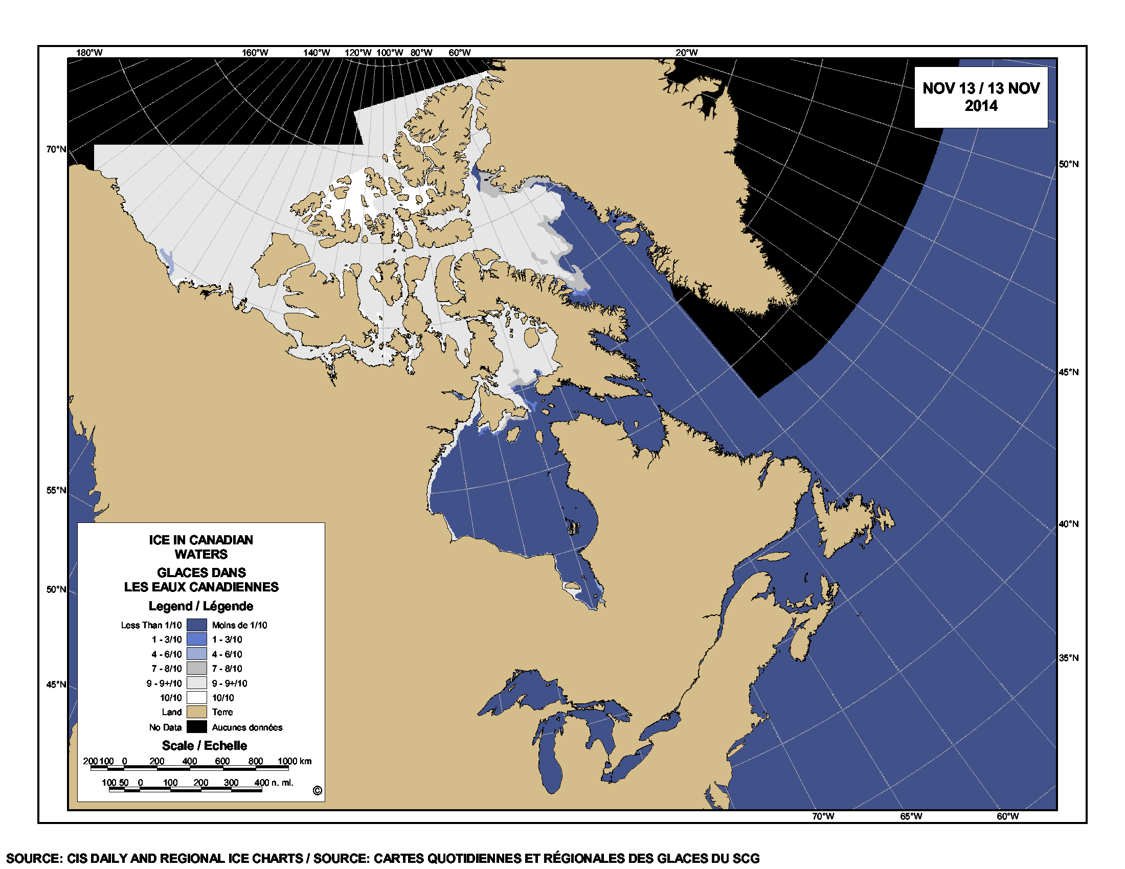
I keep coming across mentions of a grandiose plan for future polar bear research and conservation called the “Circumpolar Monitoring Framework for Polar Bears.”

This “framework” plan was referred to extensively at the recent International Polar Bear Forum (aka the “Meeting of the Parties” that signed the 1973 conservation treaty) held in Moscow, December 3-6, 2013 (see posts about the meeting here, here, and here). In fact, government representatives of all Arctic nations present at that meeting agreed in principle to support the proposed plan.

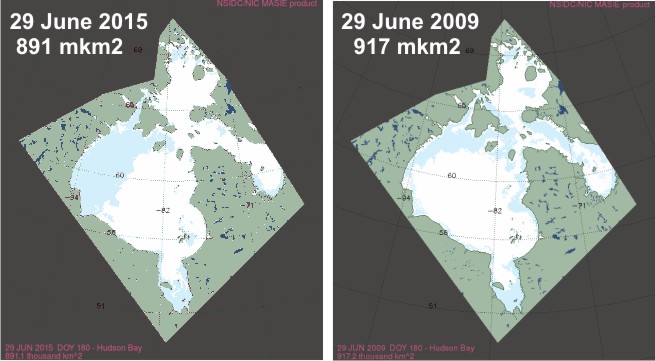
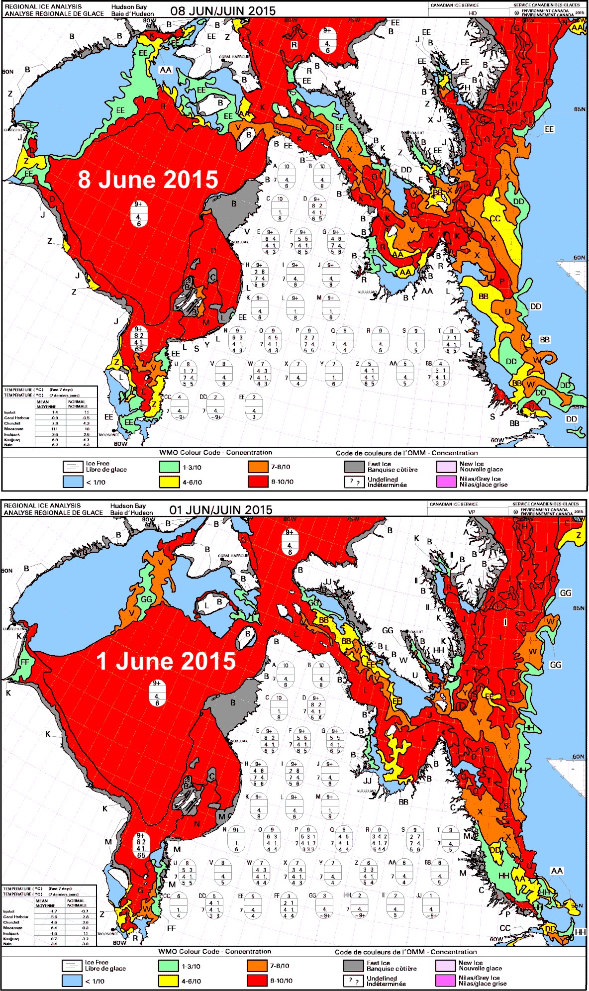
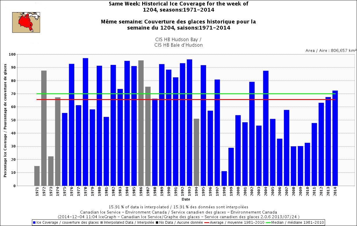
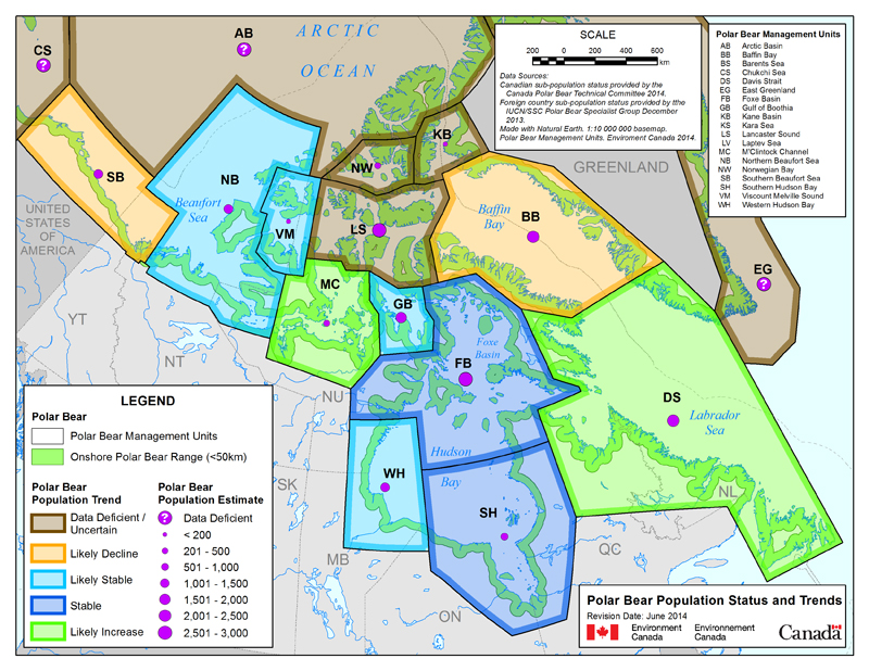
No media reports that I’ve come across after the Moscow polar bear meeting explained what the “monitoring framework” involved, so I’ve composed a brief summary and commentary, aided by some images from Dag Vongraven’s presentation in Moscow (Vongraven 2013; pdf here).

In short, Arctic government representatives at the Moscow forum agreed that all future polar bear research should be constrained by the premise that increases in global temperatures over the next century will occur exactly as predicted by climate models and will negatively affect polar bears precisely as predicted by models devised by polar bear biologists. Under the plan, subpopulations that are already showing predicted effects of global warming will get the bulk of research funds, while regions that are paradoxically not responding as predicted will get much less money for research and survey efforts. 

This strategy proposes a coordinated research plan that is blatantly agenda-driven: implementing it would seriously compromise the usefulness of all research results generated for decades to come. I don’t think it’s anything close to being a scientifically valid plan, but decide for yourself. 

Figure 1. Vongraven 2013, Slide 1.

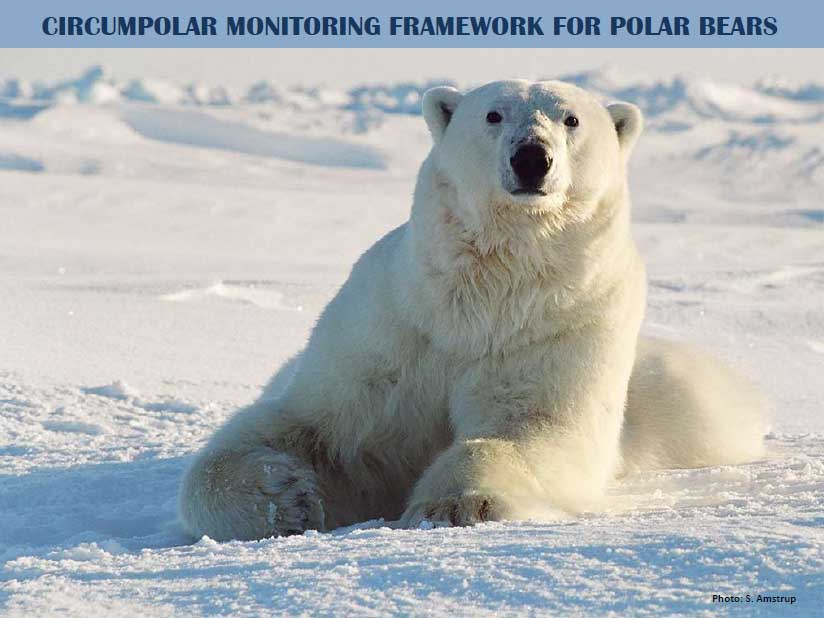
Figure 1. Vongraven 2013, Title slide.

Continue reading