Tag Archives: Beaufort Sea

Arctic polynyas and sea ice extent in Canada at 20 May 2015

The map of sea ice extent in Canada at 20 May 2015 is an almost-perfect example of the placement of recurring patches of open water polynyas that were present in the Canadian Arctic at this time of year in 1975-1979. Notes from field work on shore leads in Hudson Bay ice at May, 1948 offer further insight into the current pattern of sea ice cover on the bay.

Polynyas and shore leads vs sea ice at 20 May 2015_PolarBearScience

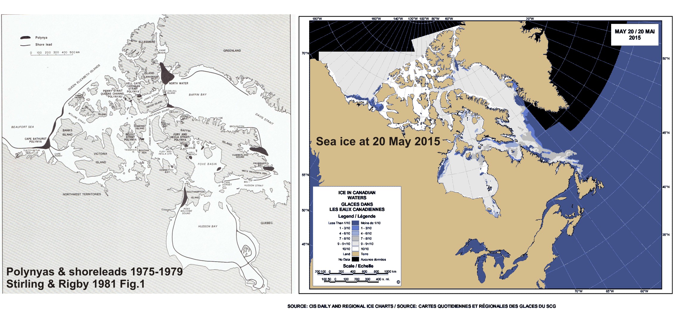
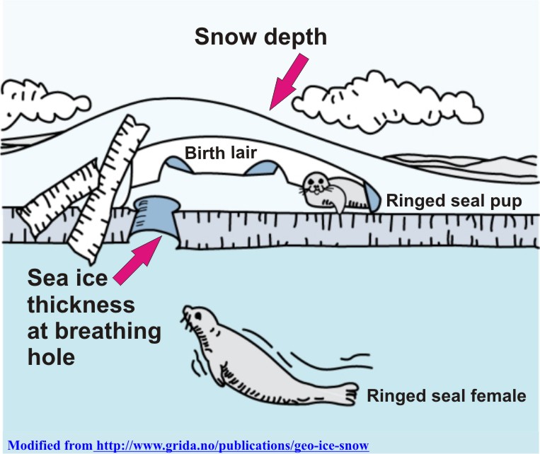
May is traditionally the time when recurring polynyas in the Canadian Arctic become more prominent and persistent shore leads (cracks in the ice near shore, also called “flaw leads”) become wider. Polar bears hunt around these polynyas because ringed and bearded seals congregate around them in the spring (Stirling et al. 1981; Stirling 1997). These polynyas are often not truly “open water” but covered by thin ice that’s easy for seals to break through.

Slight differences in location and size of polynyas and shore leads from year to year (especially in spring) are governed primarily by prevailing winds (Dunbar 1981:29) and to a lesser extent, currents. See my previous discussion on Beaufort Sea polynyas, with references: Beaufort Sea polynyas open two weeks before 1975 – open water is good news for polar bears.

This suggests that while sea ice cover over Hudson Bay and the Beaufort Sea is now a bit below average for this time of year (as the maps for this week show), it does not necessarily portend an earlier breakup or longer open-water period later in the year.

Continue reading

Beaufort Sea polynyas open two weeks before 1975 – open water is good news for polar bears

With masses of very thick, multiyear ice off Alaska this spring, the developing polynyas (open water) at either end of the Beaufort Sea are providing essential polar bear hunting habitat.

SB polynyas on ice thickness map 14 May 2015_PolarBearScience

Patches of open water in the Beaufort Sea are naturally recurring phenomena. This year we have two excellent examples, shown by the yellow arrows in the sea ice thickness map above (from the Naval Research Laboratory).

The eastern-most polynya forms in the Canadian portion of the Beaufort most years in the spring. This open water feature is so common it has a name – the Cape Bathurst polynya. Last year, there wasn’t an obvious polynya there until sometime in June, but in 1975, a patch of open water almost as large (or larger) as this year’s had developed by the end of May (Fig. 1).

Figure 1. Cape Bathurst polynya at 28 May 1975 (Smith and Rigby 1981: Fig. 14h), with the extent probably underestimated, and the polynya this year at 14 May (Canadian Ice Service). Click to enlarge.

Figure 1. Cape Bathurst polynya at 28 May 1975 (Smith and Rigby 1981:Fig. 14h) and the polynya this year at 14 May (Canadian Ice Service). See discussion in the text below about the relative sizes. Click to enlarge.

According to the experts that study them, the timing and extent of the polynya formation depends on wind (Dunbar 1981:29), not temperature. This means that this spring’s polynya formation in the eastern Beaufort isn’t a symptom of global warming, it isn’t missing polar bear habitat,” and it isn’t a sign of early sea ice breakup.

In fact, the Cape Bathurst polynya is a critical place for ringed seals and bearded seals to congregate in spring. Therefore, this is where many Southern Beaufort polar bears go to hunt. The presence of the polynya is especially crucial in years like this one, when very thick sea ice covers most of the Beaufort Sea.  Continue reading

Snow depth over spring sea ice affects polar bear feeding success and ringed seal survival

Snow depth over sea ice in spring affects the hunting success of polar bears on ringed seal (Phoca hispida) pups, but the relationship is more complicated than you might think and there is less data on this phenomenon than you would believe.

Ringed seal lair_snow and ice thickness_PolarBearScience_sm

Regional snow depth in spring (April-May) varies naturally from year to year due to weather patterns driven in part by long-term climate cycles (like the Atlantic Multidecadal Oscillation, Pacific Decadal Oscillation, and the Arctic Oscillation).

This year, it was very cold in Eastern North America, with record-breaking snow fall in some areas. Snow depth was apparently greater than average over Hudson Bay sea ice this spring but was it deep enough to have impaired polar bear hunting success?

Continue reading

Polar bear habitat update – sea ice for hunting plentiful in all subpopulation regions

Preferred polar bear habitat is said to be 50% concentration or higher over continental shelves, which describes all but the fringes of sea ice extent today, including Hudson Bay, the Southern Beaufort, and the Barents Sea.

Preferred polar bear habitat 50pc concentration_May 8 2015_PolarBearScience

However, polar bears – excellent swimmers that they are – are quite capable of utilizing areas with 15-50% sea ice concentration if necessary (Durner et al. 2004; Rode et al. 2014:79), especially when prey are plentiful.  This would account for the fact that there are still sightings of polar bears in and around northern Newfoundland (see previous post here and photo below1), where ice concentration is in the 30-50% range.

Photo with this news story (7 May 2015): "(Update) Polar bear sighting in Croque"

Photo with this news story (7 May 2015): “(Update) Polar bear sighting in Croque”

Continue reading

Tracking polar bears in the Southern Beaufort, with a sea ice surprise – April 2015 map

USGS biologists were clearly busy this spring putting more satellite radio collars and glue-on tags on Southern Beaufort Sea polar bears but there’s some surprising information in their April 2015 tracking map about current sea ice conditions.

From the 2013-2014 issue of  “Polar Bear News” (USFWS).

From the 2013-2014 issue of “Polar Bear News” (USFWS).

What’s interesting is that the sea ice maps they use show less dark spots that might be open water this year than were present last year in late April. Oddly, this phenomenon has one prominent biologist worried about “challenging” polar bear habitat developing this year – without mentioning last year at all.

The USGS track map for April 2015 is copied below.1
Continue reading

Tracking polar bears in the Beaufort Sea – March 2015 map

Here is the March 2015 follow-up to my post on the July 2013 track map for female polar bears being followed by satellite in the Beaufort Sea by the US Geological Survey (USGS) – “Ten out of ten polar bears being tracked this summer in the Beaufort Sea are on the ice.”

putting_collar_on_polar_bear_slider_USGS

See that post for methods and other background on this topic, and some track maps from 2012 (also available at the USGS website here). The USGS track map for March 2015 is copied below.

Three out of eight female bears tagged in the Southern Beaufort Sea were in the Chukchi Sea subpopulation region during March – not surprising, many bears cross this “boundary.”
Continue reading

Tracking polar bears in the Beaufort Sea – February 2015 map

Here is the February 2015 follow-up to my post on the July 2013 track map for female polar bears being followed by satellite in the Beaufort Sea by the US Geological Survey (USGS) – “Ten out of ten polar bears being tracked this summer in the Beaufort Sea are on the ice.”

polar_bear with collar_USGS

See that post for methods and other background on this topic, and some track maps from 2012 (also available at the USGS website here). The USGS track map for February 2015 is copied below.

There were 7 bears in February, up from 6 in January, because one of the bears has re-entered the area from elsewhere. However, many bears from the original sample have either had their collars fail, moved out of the area and stayed out, or they have died. We can’t tell from which of those options, or combinations of them, explain the reduced number still being followed.
Continue reading

Polar bear biologists try – again – to blame S. Beaufort thick spring ice on global warming

The trouble is, sea ice researchers and atmospheric scientists have not drawn that conclusion, despite what a new paper by Pilfold and colleagues imply. It shows just what lengths desperate IUCN Polar Bear Specialist Group  (PBSG) biologists will go to in order to link the recent decline of Southern Beaufort bear numbers to global warming while ignoring similar past declines.

Beaufort Sea pressure ridges_Spring 1949 wikipedia sm

Continue reading

Tracking polar bears in the Beaufort Sea – January 2015 map

Here is the January 2015 follow-up to my post on the July 2013 track map for female polar bears being followed by satellite in the Beaufort Sea by the US Geological Survey (USGS) – “Ten out of ten polar bears being tracked this summer in the Beaufort Sea are on the ice.”

Tranquilized_pb570_S Beaufort March 2014_USGS

See that post for methods and other background on this topic, and some track maps from 2012 (also available at the USGS website here). The USGS track map for January is copied below.

There are only 6 bears being followed now, which means a few more collars have failed, or the bears have moved out of the area or died.
Continue reading

‘Threatened’ status for Arctic ringed seals under ESA makes no sense

Recent research (Crawford and Quakenbush 203; Rode et al. 2014) has shown that sea ice declines in the Chukchi and Beaufort Seas have made life better for ringed seals, not worse (as predicted) – ringed seals are in better condition and reproducing better than they were in the 1970s. Why? Ringed seals do most of their feeding in the open-water period (Young and Ferguson 2013), so a longer open-water season means fatter, healthier seals and more fat pups for polar bears to hunt the following spring.

Ringed_seal_2_NOAA

However, Arctic ringed seals (as well as bearded seals) were designated as ‘threatened’ by the USA in 2012 under the Endangered Species Act, based on predicted ice and snow declines due to prophesied global warming. These listings are all about future threats, with no pretense of on-going harm.

Virtually no other Arctic nation has taken this step for Arctic seals — see previous discussion here. There are lots of ringed seals — an estimated 3-4 million world-wide and about 1.7 million within the critical habitat proposed by NOAA (see below).

As weak as the case for listing polar bears as ‘threatened’ has proven to be, the case for listing ringed and bearded seals is even more feeble (a judge has already sent the bearded seal listing back to the drawing board).
Continue reading