Tag Archives: breakup

Polar bear news: 1st fat bear ashore in WHB, trouble in S. Greenland, and more hybrid hype

Last week, among other events, the first fat polar bear of the season was photographed on shore in Western Hudson Bay, a fat bear was run out of town in South Greenland, and media outlets spread misinformation – apparently preferring global warming hype to rational facts.

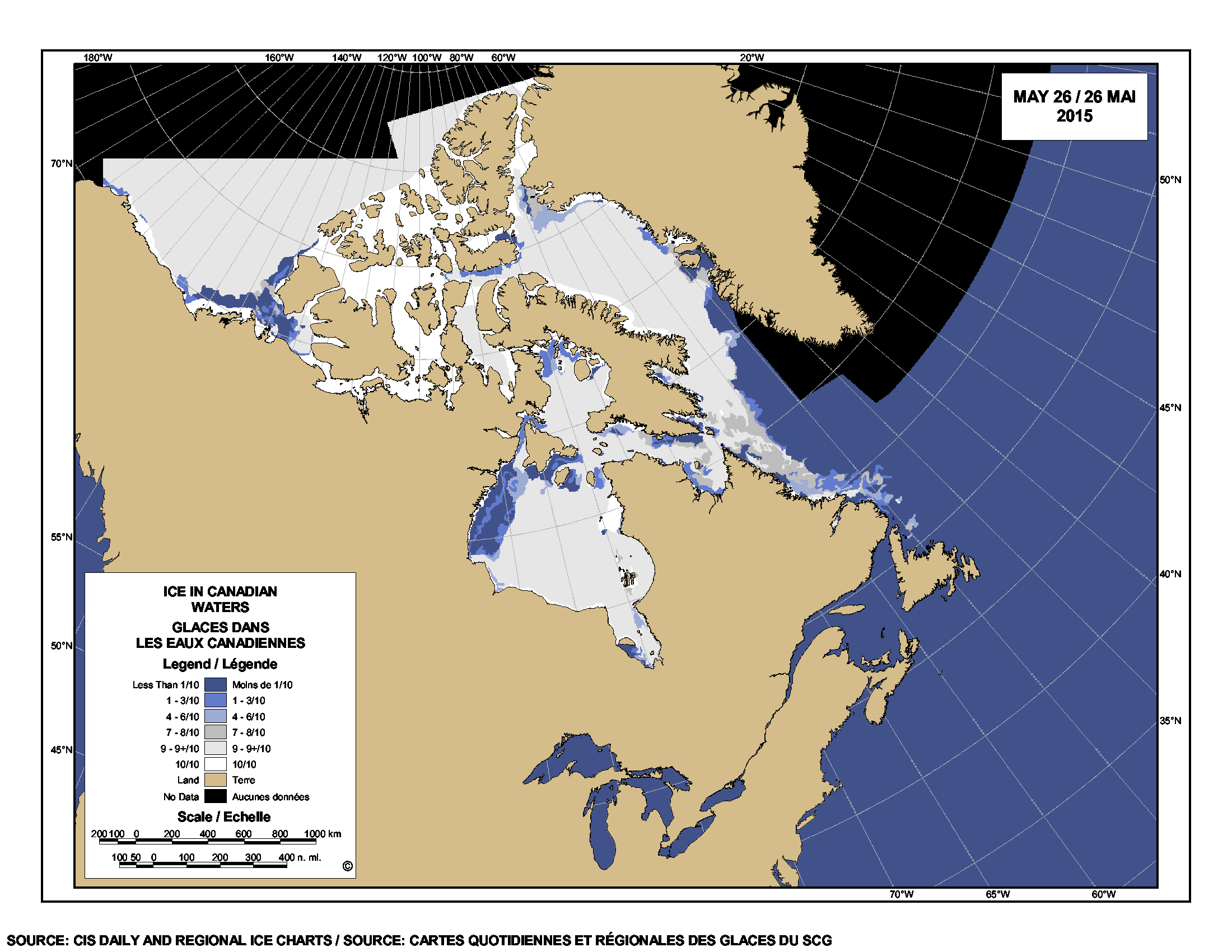
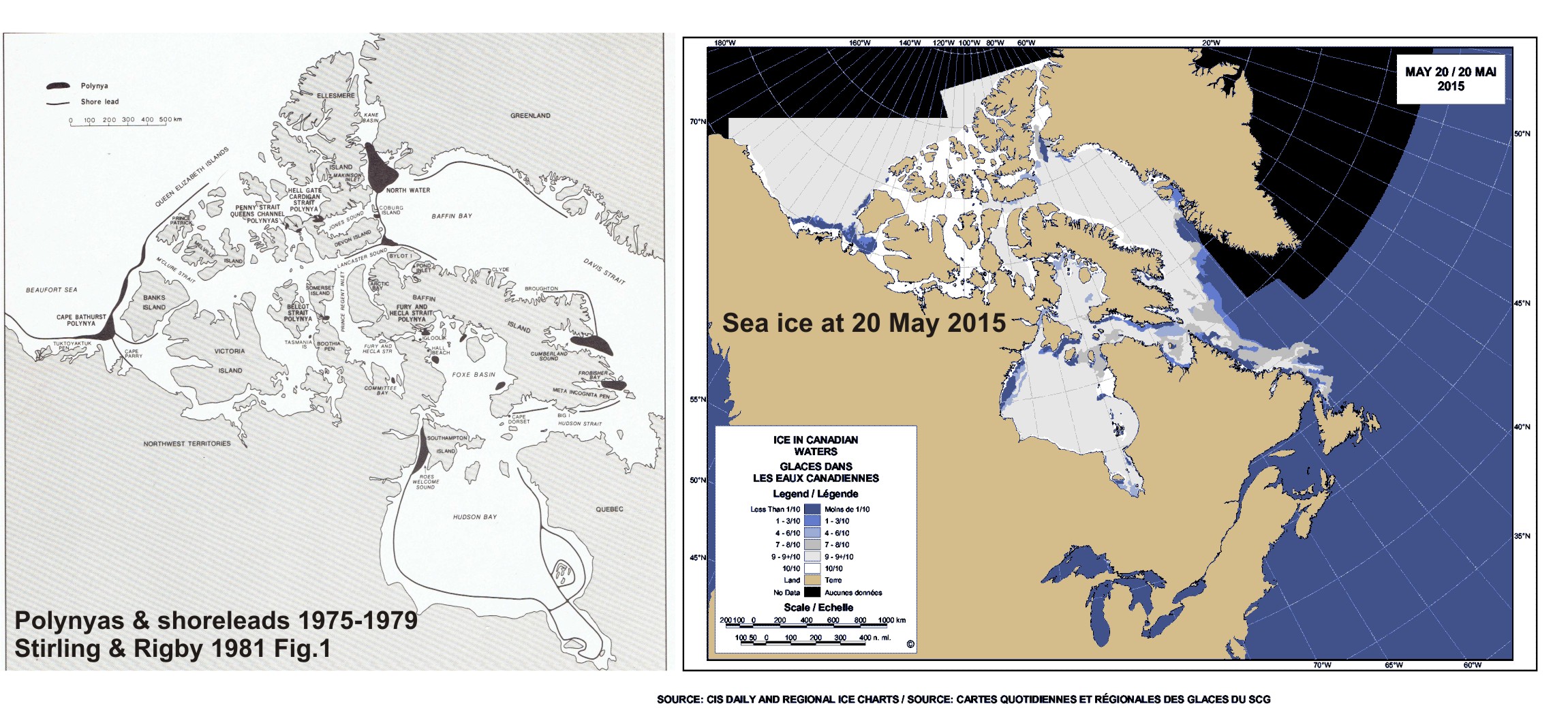
1) First polar bears have been seen onshore in Western Hudson Bay in Wapusk National Park near Cape Churchill (map below) on 18 June this year, apparently fat and well prepared for the summer fast. My informants tell me a few bears usually come ashore in June near Churchill before ice conditions make this necessary; the bulk of the population will probably continue seal hunting for a few more weeks. Those bears will come ashore along the southwest coast (near Polar Bear Provincial Park, in Ontario, see Fig. 2 below). They’ll make their way north to the Churchill area in time for freeze-up in the fall. Watch one fat bear caught on camera on 18 June, below :

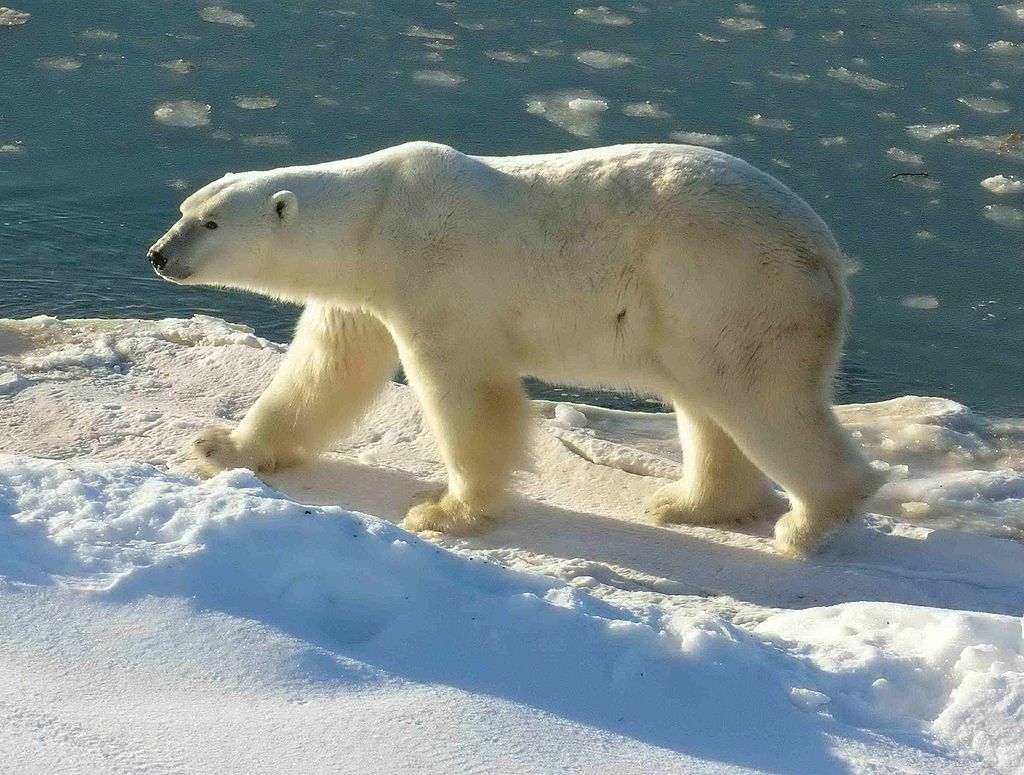
2) Fat polar bear spotted in Nanortalik, Southern Greenland 18 June 2015, a bit further south than usual. People from the community drove it away, but not before taking lots of pictures.

Greenland South_polar-bear-nanortalik-08_henrik-hansen_June_18_2015

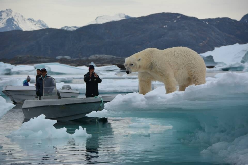
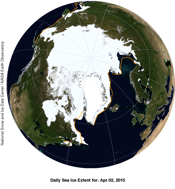
Some very cool photos, including the one above (taken by Henrik Hansen), worth a look. This bear was in excellent condition, well prepared for the summer fast ahead, whether he ends up spending it on shore somewhere (but not near this community!) or on the sea ice further north in SE Greenland (Fig. 1 below). The ice in that areas is probably broken up (~15-30% concentration) but this is enough for the bear to swim from flow to flow to make it’s way up the northeast coast where most East Greenland bears spend the summer.
Continue reading

When was the earliest ice breakup year for Western Hudson Bay polar bears?

Was 1990 really the earliest ice breakup year for Western Hudson Bay polar bears – and why aren’t breakup dates derived from the same data identical? Two serious questions that need answering.

Sea ice extent Canada 2015 June 17 CIS

The suggestion a few weeks ago by Andrew Derocher that the unusual breakup pattern of sea ice breakup in Hudson Bay this year might set a new record reminded me how often I’ve questioned the claim that 1990 had the earliest breakup for WHB since 1971.

I call this date into question for two reasons: 1) sea ice maps and charts like those shown below suggest an early breakup in 1990 was not possible, by any definition of the term; 2) none of the research reports on WHB bears, for periods that included 1990, mention that breakup in 1990 was especially early, even though many commented (often at length) about the especially late breakup in 1992.

How much does this very early breakup in 1990 contribute to the apparent declining trend in breakup dates since 1979?1  Is the early breakup date in 1990 real, perhaps a bizarre consequence of analyzing the data square-by-square over a grid? Or, were there errors in 1990 sea ice data that eventually got corrected by sea ice folks but not by polar bear biologists?

UPDATE 17 June 2015 PDF HERE of this post, with higher resolution images, for those who want to explore the questions I’ve posed or share them.
Continue reading

Same amount of sea ice for Hudson Bay polar bears as 2013, bears still on the ice

Sea ice coverage for Hudson Bay on 14 June converged on levels recorded in 2013, when breakup was slightly later than the average of the last two decades.

r10_Hudson_Bay_ts

There is also more ice over Hudson Bay than there was in 2011, which was an early breakup year (charts for other Arctic regions here, originals here).

Andrew Derocher notes (via twitter) that rather than heading to shore, most of the Hudson Bay bears with satellite tracking collars (7/10) are out on the ice (Fig. 1 below). They appear to be hunting along the ice edge, where they are most likely to find seals.

Update 17 June 2015: Sea ice images for the week 18 June 2015 compared to other years added below, for Hudson Bay and the Beaufort Sea.

Continue reading

Hudson Bay breakup progressing slowly, still lots of polar bear habitat

Not much change in sea ice coverage since last week – most of Hudson Bay is still covered with concentrated ice, which is good news for Western and Southern Hudson Bay polar bears. They are still free to roam and hunt over most of the ice-covered bay.

Hudson Bay breakup 8 June 2015 vs 1 June_PolarBearScience

There may be slightly less ice than average for this time of year (Fig. 1, below) but coverage is still >70% with concentrated ice and does not appear to be melting quickly (see charts above and Fig. 2, below).

The dates for three previous earliest breakups according to Lunn and colleagues (Fig. 3) have come and gone, as all were in the first week of June (more on that in an upcoming post) – no records broken. More graphs and maps below, see previous posts here and here.
Continue reading

Hudson Bay breakup date for 2015 will really depend on which definition you use

Is breakup imminent for Hudson Bay sea ice? Probably not, but this year more than ever, it will depend on how you define it. Hudson Bay concentratation_2015 June 1_CIS Despite a large patch of open water in western Hudson Bay (CIS chart above, for 1 June), there is still more than 70% sea ice coverage over the entire bay as of this week, when you use the standard breakup definition of 50% ice coverage (Fig. 1).  Ice remaining over the bay is mostly 90% or greater, as the chart above shows – which means there is still a lot of polar bear hunting habitat remaining.

Figure 1.

Figure 1. Sea ice coverage over Hudson Bay, as a percentage, for the week of 4 June, 1971-2015. Click to enlarge.

The interconnected region of Hudson Bay, Hudson Strait, and southern Davis Strait (Fig. 2), what the Canadian Ice Service calls “Regional Hudson Bay,” is only slightly below average for the week of 4 June.

Regional Hudson Bay, week of 4 June.

Figure 2. Regional Hudson Bay, week of 4 June. Click to enlarge.

Since ice concentration is factored into breakup date calculation, a record-early breakup is simply not possible, since the previous record date (2 June, for 1990) has already passed. It might be an earlier than average breakup year but not very early, based on the 50% coverage definition (Fig. 3, below). This year, because of the unusual pattern of breakup of Hudson Bay ice, it will be critical for polar bears which definition of breakup is used – the old, 50% method (adopted because it’s what sea ice professionals used) or the newest one, which was determined to be most relevant to WHB polar bears (Cherry et al. 2013).

UPDATE 6 June 2015: I’ve added the forecast for ice conditions over the summer for North America (which for these folks includes June because it’s aimed at temperate NA, polar bear folks call June the end of spring), provided by the Canadian Ice Service: “Seasonal outlook for North American Arctic Waters issued by the North American Ice Service on 2 June 2015” [points of potential interest marked] The sea ice forecast (Table 1) for southwestern Hudson Bay (where most western and southern Hudson Bay polar bears come ashore) is for complete ice melt by 1 Aug, eight days later than the earliest date over the period 1968-2013. Time will tell if that’s what happens.
Continue reading

Hudson Bay sea ice coverage is atypical this year but what does that mean for polar bears?

Churchill_Polar_Bear_2004-11-15 Wikipedia

There is a rather large patch of open water in the northwest sector but what’s also unusual about breakup this year is the virtual lack of open water in eastern Hudson Bay – that almost never happens (compare to 2013 here). In addition, there’s still very little open water in Hudson Strait, which connects Hudson Bay to Davis Strait in the east – that’s also unusual.

Figure 1.  Sea ice extent over Hudson Bay and Hudson Strait at 26 May 2015. Canadian Ice Service.

Figure 1. Sea ice extent over Hudson Bay and Hudson Strait at 26 May 2015. Canadian Ice Service. Click to enlarge.

The question is: does the somewhat unusual pattern of ice cover at this date – which developed rapidly over the last few weeks – suggest we can predict whether polar bears will have a shorter-than-average hunting season?

To answer that, you have to look at maps generated by the same source over several years. The result, in my opinion, is inconclusive – while so far, this year looks a bit more like 2009 (which was a very late sea ice breakup year) than it does 2011 (which was an early breakup year), it’s really too early to tell.

I suggest we simply won’t know for another month or so which pattern will prevail. However, that hasn’t stopped IUCN Polar Bear Specialist Group member Andrew Derocher (via Twitter, e.g., here and here, among many others) from suggesting that this year’s pattern is likely a portend of doom for Hudson Bay polar bears. See what you think.
Continue reading

Arctic polynyas and sea ice extent in Canada at 20 May 2015

The map of sea ice extent in Canada at 20 May 2015 is an almost-perfect example of the placement of recurring patches of open water polynyas that were present in the Canadian Arctic at this time of year in 1975-1979. Notes from field work on shore leads in Hudson Bay ice at May, 1948 offer further insight into the current pattern of sea ice cover on the bay.

Polynyas and shore leads vs sea ice at 20 May 2015_PolarBearScience

May is traditionally the time when recurring polynyas in the Canadian Arctic become more prominent and persistent shore leads (cracks in the ice near shore, also called “flaw leads”) become wider. Polar bears hunt around these polynyas because ringed and bearded seals congregate around them in the spring (Stirling et al. 1981; Stirling 1997). These polynyas are often not truly “open water” but covered by thin ice that’s easy for seals to break through.

Slight differences in location and size of polynyas and shore leads from year to year (especially in spring) are governed primarily by prevailing winds (Dunbar 1981:29) and to a lesser extent, currents. See my previous discussion on Beaufort Sea polynyas, with references: Beaufort Sea polynyas open two weeks before 1975 – open water is good news for polar bears.

This suggests that while sea ice cover over Hudson Bay and the Beaufort Sea is now a bit below average for this time of year (as the maps for this week show), it does not necessarily portend an earlier breakup or longer open-water period later in the year.

Continue reading

Polar bear habitat update: Hudson Bay sea ice breakup on track

Hudson Bay sea ice coverage is only slightly below average for this time of year (week of 14 May, below) but well above levels for 2006, when Western Hudson Bay breakup was relatively early).

Sea ice Canada 2015 May 14_CIS

Figure 1. Sea ice coverage over Hudson Bay for the week of 14 May, 1971-2015. Canadian Ice Service. Click to enlarge.

Figure 1. Sea ice coverage over Hudson Bay for the week of 14 May, 1971-2015. Canadian Ice Service. Click to enlarge.

Even at its highest extent in April, Hudson Bay is only 97-98% ice covered (due to persistent shoreleads and polynyas), which means ice levels are currently only 10% or so below maximum. In other words, there is still lots of polar bear hunting habitat over the bay.

That’s a bit lower than ice coverage was for the last two years at this date (2013-2014), which had average or above average ice cover. However, there is currently a bit more ice on Hudson Bay than there was in 2011 and 2012 – and much more than there was in 2010 and 2006.
Continue reading

Polar bear habitat update: highly concentrated ice in eastern Hudson Bay this spring

Sea ice in eastern Hudson Bay (bright white in the map below) is more concentrated than at this time last year and similar to the ice found in the Central Canadian Arctic.

Sea ice extent Canada 2015 April 11 CIS

There is more concentrated ice (10/10 concentration) in the east side of the Bay than there was in 1992, a heavy ice year blamed in part on the eruption of Mt. Pinatubo (Chambellant et al. 2012) that resulted in the latest breakup date for Western Hudson Bay since 1991.

Continue reading

Superb sea ice conditions for polar bears worldwide during their critical feeding period

Prognosis, excellent. The sea ice hunting platform that polar bears require is everywhere and Davis Strait ice extent is the fourth-highest it’s ever been at this time of year.

Sea ice extent global 2015 April 2 NSIDC with anomaly WUWT

The spring feeding period is a messy, brutal business – many cute baby seals will die as polar bears consume 2/3rds of their yearly food supply over the next few months (April – June/early July), while sea ice is abundant.

Arctic marine mammals_Dec 31 2014_Polarbearscience

That leaves the remaining 1/3 of their energetic needs to be met over the following 9 months (most of it in late fall (late November/December) and hardly any during the summer months, regardless of whether the bears are on land or out on the sea ice) or over the winter. Continue reading