Tag Archives: Davis Strait

Hudson Bay sea ice above average for this date – more good news for polar bears

It’s only the 4th of December and Hudson Bay ice formation is way up over late 2000s coverage for this date — and higher than 2012, which had the lowest overall September ice extent for the Arctic since 1978.

Hudson Bay freeze-up same week_Dec 4 1971_2014 w average

This means boom times for Western and Southern Hudson Bay polar bears as sea ice formation is several days to a week ahead of last year. And as I mentioned in my last post, average November ice coverage across the Arctic this year was higher than 2003. Don’t forget that 2/3’s of the world’s polar bears live in Canada (see recent status update here; map below).

Figure 4. The Davis Strait (DS) subpopulation region runs from just below the Arctic Circle at the north end to at least 470N in the south. About half of DS lays at the same latitude as Western Hudson Bay (WH). Courtesy Environment Canada.

Polar bear population status in Canada. Courtesy Environment Canada.

More maps and charts below.
Continue reading

Polar bear habitat update – November 2014 average sea ice levels higher than 2003

Average polar bear habitat for November 2014 was well within two standard deviations1 and higher than 2003, according to the November report from the National Snow and Ice Data Center (line and labels added, below).

Arctic ice Nov aver_NSIDC_sm_PolarBearScience

Notice that the lowest average November level occurred in 2006not 2007 (after the second lowest September extent since 1978) and not 2012 (after the lowest September extent since 1978). Take note that the scale on the graph above does not go to zero but to a whopping ~9.5 million square km!

Quotes from the NSIDC monthy report and sea ice maps for November 2014 and 2 December 2014 below.

UPDATE 3 December 2014: CIS has issued a new ice map corrected for ice level on Hudson Bay – new map below.
Continue reading

Davis Strait polar bear habitat – the sea ice is forming, but it’s late!

Since 1971, there have been only two years with as little sea ice in Davis Strait as there was this year at this time – 2003 and 2010. But the ice is forming rapidly and history shows it will likely catch up enough by next week to allow most Davis Strait polar bears to start hunting seals except along the Labrador coast.

Courtesy IUCN PBSG

Courtesy IUCN PBSG

Have a look at the ice maps and charts below from the Canadian Ice Service for the status of freeze-up in Davis Strait.

UPDATE 30 November 2014: Sea ice extent map from NSIDC added.

Continue reading

Labrador polar bears face a longer ice-free season than Hudson Bay bears, but do well

Pretty typical ice levels in both regions for this time of year – Davis Strait polar bears (especially those in Labrador) are still onshore while Hudson Bay bears (even those in the south) have their sea ice hunting platform back.

Davis Strait Hudson Bay freeze-up at Nov 25 2014_PolarBearScience

Funny thing is, the Davis Strait subpopulation may still be increasing despite a longer ice-free season than Western Hudson Bay. And bears in the south of that region – who spend the summer onshore in Labrador – have the longest ice-free season of all1 yet according to the latest survey they were even doing better than bears in northern Davis Strait.

That apparent paradox has an easy explanation – sea ice extent in late summer/early fall (length of the ice-free season) has much less of an impact on polar bear health and abundance than the state of the food supply in the spring. More seals in spring, polar bears do well; few seals in spring, polar bears starve.

Continue reading

“Meltdown: Terror at the Top of the World” — new book exploits polar bear attack to sell fear of sea ice decline

The polar bear attack that was all over the news last summer is now an ebook about global warming. The Maine lawyer who was mauled by a bear while on a hiking trip to Labrador (and lived to tell the tale) has allowed his story to be co-opted by an activist journalist to promote fears of sea ice decline, polar bear extinction, and man-made global warming.

Melt-down_Terror at the Top of the World_Nov 12 2014 press release book cover

The press release issued yesterday by the news group that published the book and employs author Sabrina Shankman (InsideClimateNews), described it this way:

“A riveting new e-book about the battle between man, beast and Nature in a warming world. Called Meltdown: Terror at the Top of the World, the e-book tells the story of the hikers’ harrowing encounter with a polar bear; of the plight of the polar bear in general, facing starvation and extinction as the sea ice melts and its habitat disappears; and of the Arctic meltdown, the leading edge of man-made climate change.”

I have little doubt the man mauled by the bear was indeed terrified and that his companions were as well. However, that horror is exploited shamelessly in this book as a means to promote anxiety over the future survival of polar bears and instill panic over a prophesied Arctic “meltdown.”
Continue reading

Status of Canadian polar bear populations has been changed – more good news

According to maps dated June 2014, Environment Canada (EC) has changed the trend status of several Canadian subpopulations — without any announcement or publicly-available documents explaining the basis of the changes.

Figure 3. "Series of Circumpolar Polar Bear Subpopulation and Status Trend Maps 2010, 2013 & 2014" Note the asterisk below the 2014 map, which is dated "June 2014" and is different in its status assessment from the one released in February 2013 by the PBSG. Original here.

Figure 1. Environment Canada’s “Map 4: Series of Circumpolar Polar Bear Subpopulation and Status Trend Maps 2010, 2013 & 2014.” Original here.

And would it surprise you to learn that virtually all of these status changes reveal more good news about polar bears?
Continue reading

Polar bear habitat: Spring 2014 in Eastern Canada was much better than 1969

It was a good year for polar bear habitat in the southern portions of Eastern Canada this spring – surprisingly, much better than it was in 1968 through 1970. And since spring conditions are what really matter to polar bears, this is good news indeed.

Environment Canada’s Canadian Ice Service recently published a nice little summary that has some rather eye-opening graphs. These describe the conditions for polar bears in the southern Davis Strait subpopulation – the one whose population size increased so dramatically between 1974 and 2007 despite lower-than-average ice extent in some years, even while their body condition declined (see here and here).

Environment Canada - Ice maps regions at July 26 2014

[Fitting post for the second anniversary of this blog, I think – more below1]

Note that I’ve added a “Blog Archive” page that lists all of my posts, easier to browse now that there are more than 200 of them.
Continue reading

Polar bear habitat update – ice coverage at the beginning of this year’s critical feeding period

Polar bears are all out on the sea ice at this time of year, feeding on new-born seal pups. Here’s a look at what the ice conditions are like at this critical time.

Polar_Bear_male on sea ice_Alaska Katovik Regehr photo_April 29, 2005_sm labeled

end April extent NSIDC May 4

The ice extent is still well within two standard deviations from the 1981-2010 average, which indicates no deviation from natural variation, as the graph (below) for May 1, 2014 from the US National Snow and Ice Data Center (NSIDC) shows.

Sea ice extent 2014 May 1_NSIDC_graph

Between the official spring maximum (according to the NSIDC ) on March 21, with a total extent of 14.8 million km2, the ice slowly retreated in some regions and increased in others, while most regions remained pretty much the same. This is an important reminder that the Arctic as a whole is not a homogeneous region but one with marked regional variation.

As has been noted elsewhere (Sunshine Hours), ice in the Greenland Sea (habitat of ‘East Greenland’ bears) and the Barents Sea both increased in extent over this period. Bering Sea ice (habitat of southern ‘Chukchi Sea’ bears) declined markedly but Baffin Bay/Gulf of St. Lawrence ice (habitat of ‘Davis Strait’ bears) declined much less, as NOAA’s MASIE maps copied below show very well.

Continue reading

Davis Strait polar bear habitat higher now than in 1979 and early 1980s

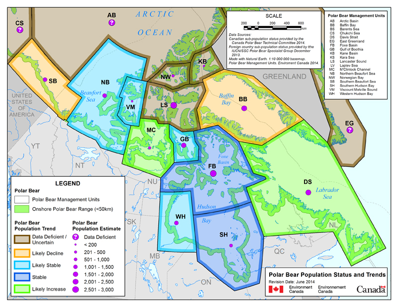
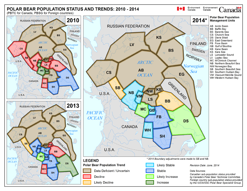
The Davis Strait polar bear subpopulation is said to be ‘vulnerable’ to the supposed effects of global warming because, like Hudson Bay, Davis Strait sea ice retreats every summer, leaving polar bears on land for several months.

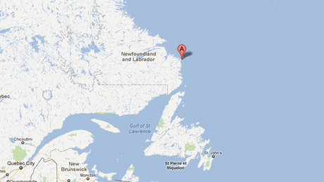
However, Davis Strait bears have been upgraded to ‘stable’ status, according to the latest table (2013) issued by the IUCN Polar Bear Specialist Group (see their boundary map for Davis Strait bears below). Recent development of sea ice in the region can only improve that rating.

[More background here and heremap-DavisStrait

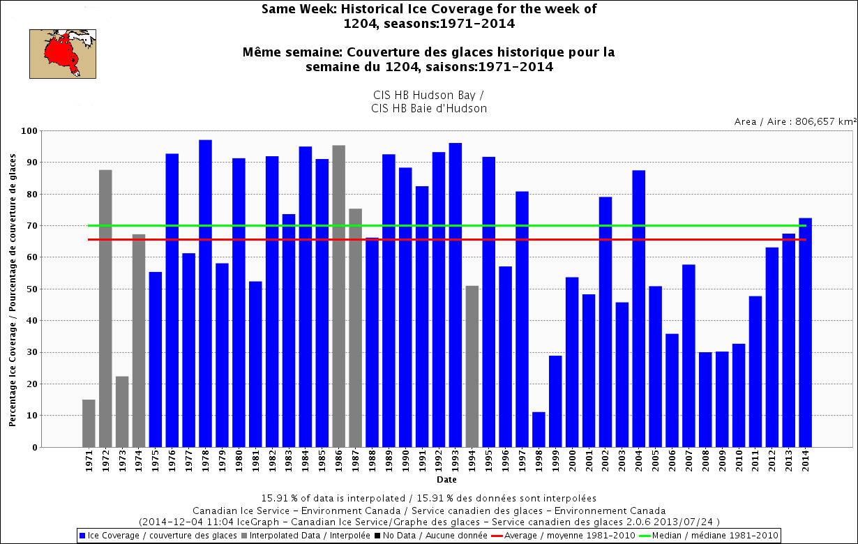
It seems that sea ice in Davis Strait is well above normal for this time of year – a recent announcement by the Canadian Ice Service (CIS) says it’s 10% above average, higher than it’s been in 25 years (h/t S. Goddard).

The Canadian Ice Service, an arm of Environment Canada, said there is 10 per cent more ice this year compared to the 30-year average.

We probably haven’t seen a winter this bad as far as ice for the past 25 years,” said Voight, referring to both the amount and thickness of the ice.

He said the Gulf of St. Lawrence is covered and some areas are “quite severe.” [my bold]

Full story here.

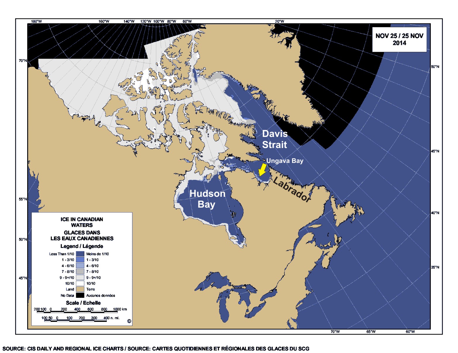
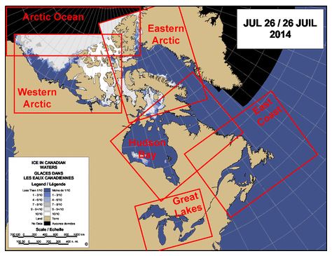
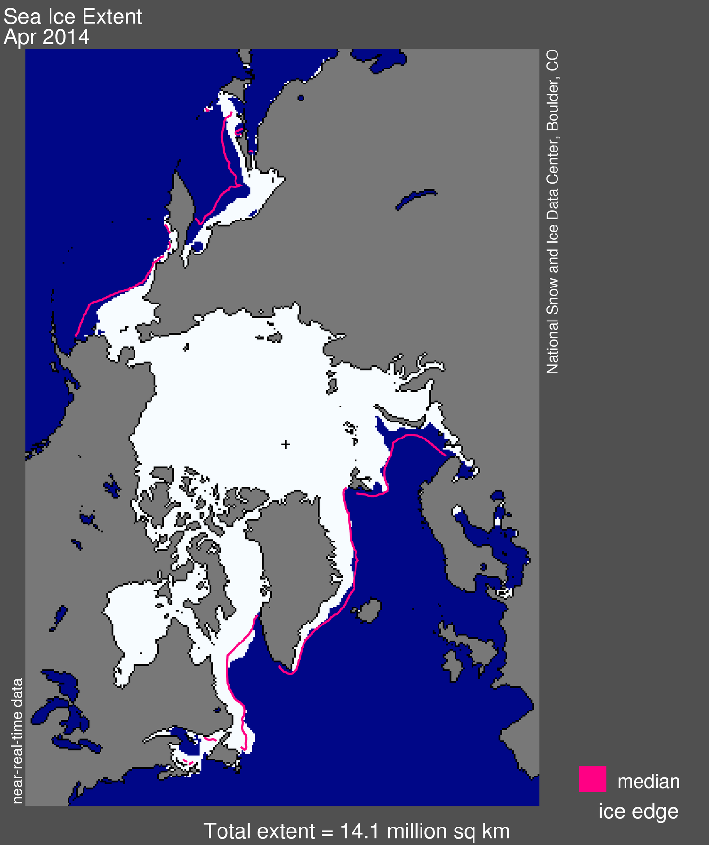
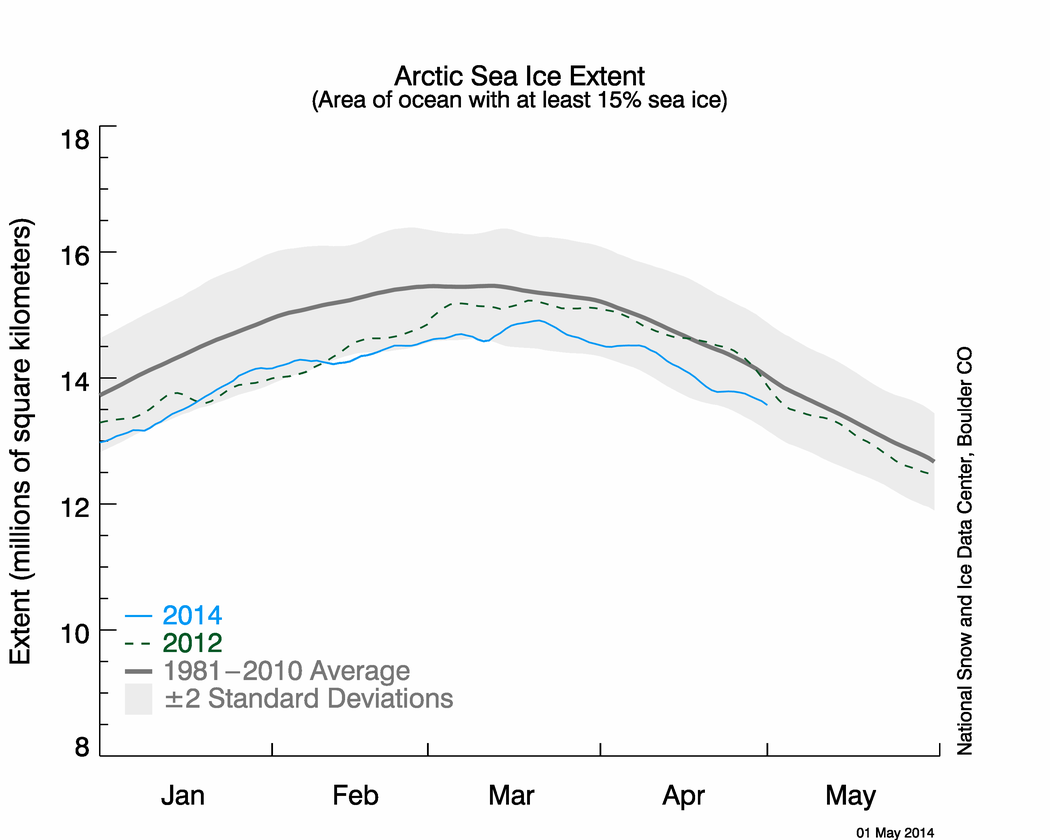
Latest ice map (March 12) below from the US National Snow and Ice Data Service (NSIDC).

As I pointed out recently here, Barents Sea ice is below average this year, largely due to natural variation in the Atlantic Multidecal Oscillation (AMO), but is higher over the western Atlantic (Sea of Okhotsk ice is below average too but there are no polar bears there).

There is lots of ice around Labrador and Newfoundland, however.

Sea ice extent 2014 March 12 NSIDC

I thought I let you see exactly what CIS are talking about: what did the ice look like 25 years ago, in 1989? What about 35 years ago, in 1979, the start of the satellite record for sea ice? It might surprise you. Continue reading

Of Labrador polar bears and sea ice way above normal off Newfoundland

A report yesterday of polar bears making a nuisance of themselves in Black Tickle, southern Labrador is the inspiration for this post. Those bears are part of the Davis Strait subpopulation (discussed previously here and here). Black Tickle is marked on the map below.

Black-tickle-map-Labrador

Arctic sea ice is tracking just at the edge of two standard deviations for this time of year but while extent is low in the Barents Sea, it is way up around the east coast of Canada.
Continue reading