Tag Archives: USGS

Pacific walruses hauled out at Point Lay Alaska again this year

A photo of a mass walrus haulout at Point Lay, Alaska taken a few days ago from a distance show thousands of animals. But no one’s counting because apparently, no one’s interested.

Walrus Pt Lay ADN story Aug 27 screencap
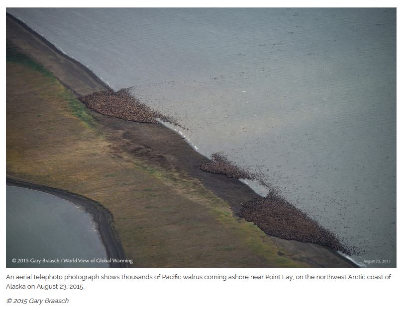
The picture on the left (above, courtesy Alaska Dispatch News) was taken 23 August by global warming activist photographer Gary Braasch, the day after a news report appeared about the US Fish & Wildlife Service and aviation authorities asking the media to approach USFWS about walrus photos and information that gave no hint that a large haulout of walruses was already in place (22 August 2015, “Federal agencies, Point Lay seek to minimize walrus disturbances” ):

“Federal agencies are stepping in to shield a North Slope village from the possibility of a deluge of international attention should a large walrus haulout develop nearby, as it has in years past — agreeing to act as an information clearinghouse on behalf of the Native Village of Point Lay.” [my bold]

Here is what the global warming activist site that published the pictures says about the haulout:

“Thousands of Pacific walrus are coming ashore near Point Lay, NW Arctic coast of Alaska. The huge sea mammals and young began coming up on this barrier island along Kasegaluk Lagoon about August 20, according to local natives. This is one of the earliest known summer haul outs of the walrus along the Alaska coast of the Chukchi Sea, according to wildlife biologists.” [my bold]

They say “thousands.” But the photos taken, reproduced in the Alaska Dispatch News story I read, were taken from a greater distance than the famous photo of ~35,000 animals released by government officials last year and looks like the total could be as large, or larger, than the 2014 haulout.

Said a Washington Post story (27 August 2015):

The U.S. Fish and Wildlife Service confirmed to the Post Wednesday evening that a mass of walruses had “hauled out,” or gathered on shore, near the remote community of Point Lay. The service did not estimate the number or provide images. But photojournalist Gary Braasch has posted dramatic photographs, taken during an Aug. 23 flyover, of what appear to be at least several thousand walruses crowding onto a barrier island.” [my bold]

Continue reading

July 2015: all 13 collared polar bears in the Southern Beaufort are out on the sea ice

Most of these bears are close enough to shore to hit the beach if that’s where they wanted to be but they’re on the sea ice.

Polar bear S Beaufort_PolarBearNews2010

I’ve been posting these USGS tracking maps for two years.1  The map archive at USGS goes back to December 2009.  Seeing all animals on the ice in July is usual for Southern Beaufort polar bears.

During August, a few of these females usually come ashore (see here and here), probably because they plan to den there later. But most polar bear females stay out on the ice, no matter how far it contracts into the Arctic Basin. Only about 5% of SB bears spend time on land during the summer.

See the July track map below and some sea ice maps and graphs for the region.
Continue reading

Polar bear doom and gloom from USGS vs. biologist Mitch Taylor’s reasoned thoughts

A few days ago polar bear biologist Mitch Taylor and Nunavut’s Gabriel Niryungaluk talked to Toronto radio host Roy Green about the recent USGS dire model predictions for the future of polar bears.

Taylor interview_5 July 2015 Polar bear numbers_radio

There’s an audio podcast and, courtesy of the valuable efforts of fellow blogger Alex Cull, a transcript. Links below, plus some excerpts of Mitch Taylor’s commentary.
Continue reading

Polar bears fine now but give us more money: US Fish & Wildlife Management Plan subtext

Between-the-lines message of the recently released (and hyped to death) Conservation Management Plan for polar bears by the US Fish & Wildlife Service is that the bears really have nothing to worry about except human-caused global warming but it will cost tens of millions of dollars over the next five years to study and manage them.

polar_bear_usfws_no date_sm

So filled with double-speak, misinformation, and obfuscation [including the newly-invented term, “quasi-extinction floor”] that it’s no wonder some news outlets got it wrong (nowhere in this document does it say that polar bears might go extinct within ten years“). The document does, however, lay out the FWS budget for polar bears over the next five years – and it’s a real eye-opener.

Continue reading

Tracking polar bears in the Southern Beaufort June 2015 – all 17 bears out on the sea ice

Sixteen females with satellite collars plus one with a glue-on transmitter – down from 17 with collars and 6 with tags last month – all out on the ice during the month of June 2015.

Tranquilized_pb570_S Beaufort March 2014_USGS

Polar bears were captured by USGS biologists in 2014 and 2015 on the spring-time sea ice of the southern Beaufort Sea. The glue-on tags don’t seem to be holding up very well, with only one remaining out of the original eight deployed this spring.
Continue reading

USGS promotes another flawed polar bear model: GHG emissions still “primary threat”

It’s still based on the same flawed ecological premise as all previous models – it assumes that sea ice was a naturally stable habitat until human-caused global warming came along. It also uses slight-of-hand maneuvers to correlate declining summer sea ice and declining polar bear population numbers.

PolarBearCV1_USGS_2009

Just because they keep repeating the same hype doesn’t make it true.
Continue reading

Tracking polar bears in the Southern Beaufort May 2015 – thick ice and polynyas

Polar bear habitat in the Southern Beaufort for May 2015 was a contrast between the development of recurring polynyas (patches of open water) and tremendously thick sea ice. So it’s interesting to see where the polar bears tagged by USGS biologists chose to hang out.

Polar_Bear_Biologist_USFWS_working_with_a_Bear_Oct 24 2001 Amstrup photo

The total number of bears being tracked in May – 23 – is down markedly from the 30 bears USGS biologists started with in April.

Most of the collared bears were concentrated in May along the shore lead (crack of open water) that normally develops between the shorefast ice and the pack ice offshore. That’s especially understandable this year, since most of that pack ice is 3-5 m thick (10-16 ft) – see the maps below.
Continue reading

Tracking polar bears in the Southern Beaufort, with a sea ice surprise – April 2015 map

USGS biologists were clearly busy this spring putting more satellite radio collars and glue-on tags on Southern Beaufort Sea polar bears but there’s some surprising information in their April 2015 tracking map about current sea ice conditions.

From the 2013-2014 issue of  “Polar Bear News” (USFWS).

From the 2013-2014 issue of “Polar Bear News” (USFWS).

What’s interesting is that the sea ice maps they use show less dark spots that might be open water this year than were present last year in late April. Oddly, this phenomenon has one prominent biologist worried about “challenging” polar bear habitat developing this year – without mentioning last year at all.

The USGS track map for April 2015 is copied below.1
Continue reading

Tracking polar bears in the Beaufort Sea – March 2015 map

Here is the March 2015 follow-up to my post on the July 2013 track map for female polar bears being followed by satellite in the Beaufort Sea by the US Geological Survey (USGS) – “Ten out of ten polar bears being tracked this summer in the Beaufort Sea are on the ice.”

putting_collar_on_polar_bear_slider_USGS

See that post for methods and other background on this topic, and some track maps from 2012 (also available at the USGS website here). The USGS track map for March 2015 is copied below.

Three out of eight female bears tagged in the Southern Beaufort Sea were in the Chukchi Sea subpopulation region during March – not surprising, many bears cross this “boundary.”
Continue reading

Polar bear consumption of terrestrial foods – new paper misses the point

A new paper by polar bear biologists (Rode et al. 2015) argues that terrestrial (land-based) foods are not important to polar bears now and will not be in the future – a conclusion I totally agree with – but they miss the point entirely regarding the importance of this issue.

Fat bears on land in the Southern Beaufort, Sue Miller photo, well-prepared for a brief summer fast.

Whatever food polar bears consume in the summer – whether they are on land or on the ice – doesn’t really matter. What matters is how many fat-rich seals they can consume between March and June each year. The fat put on in late winter/spring from gorging on baby seals carries polar bears over the summer, no matter where they spend it.

USGS polar bear biologist Karyn Rode and colleagues (press release here) have tried to frame this issue as one about future survival of polar bears in the face of declining sea ice. However, the fact that polar bears in the Chukchi Sea and Southern Davis Strait are thriving despite dramatic declines in summer sea ice (aka an extended open-water season), proves my point and disproves their premise. Bears in these regions are doing extremely well – contrary to all predictions – because they have had abundant baby seals to eat during the spring (see here and here).

Continue reading